Your Arizona Residential Lot Awaits
County Rd 5076 : Concho, AZ 85924
Apache County, Arizona
Land Description
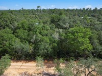
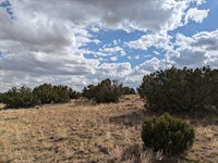
1 Acre Property in Apache County, Arizona.
Discover your perfect Arizona mountain escape.
This excellent 1-acre property in Apache County offers the ideal combination of affordability, natural beauty, and location in Arizona's stunning White Mountains region.
With cool summer temperatures, four distinct seasons, and access to world-class outdoor recreation, this property is perfect for anyone seeking a weekend getaway, retirement retreat, investment opportunity, or year-round mountain living.
At an incredibly affordable price with flexible financing, land ownership in the beautiful White Mountains is now within your reach.
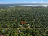
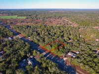
Property Address: Apache County, Arizona
Apn: 201-28-065
Property Size: 1 acre (43,560 square feet)
Zoning: Residential/Rural
GPS Coordinates (Center): 34.435100, -109.606300
Elevation: Approximately 6,350 feet
Exceptional Pricing & Flexible Payment Options
We believe everyone deserves the opportunity to own land, which is why we offer two convenient purchasing options:
Cash Purchase Option
Price: $8,499
Own your 1-acre Arizona mountain property outright for just $8,499. This represents outstanding value for property in the desirable White Mountains region with its cool summers and four-season climate. For less than the cost of a used car, you can own a full acre in one of Arizona's most beautiful and recreation-rich areas.
Owner Financing Option - No Credit Check Required.
Make your Arizona dream a reality with our simple, no-hassle financing:
Down Payment: $129
Document Fee: $250 (one-time)
Monthly Payment: $129
Term: 72 months (6 years)
Total Investment: $9,637 over 6 years
That's only $4.30 per day to own 1 acre in the beautiful White Mountains.
No banks, no credit checks, no complicated approval process. If you can afford $129 down and $129 per month, this beautiful Arizona mountain property can be yours. We make land ownership simple and achievable for everyone, regardless of credit history.
Incredibly Low Annual Property Taxes
Annual Property Taxes: $16.52
That's less than $2 per month in property taxes. At only $1.38 per month, this property has one of the lowest tax burdens anywhere in the United States. For less than the cost of a single cup of coffee per month, you can own 1 acre in Arizona's beautiful White Mountains region.
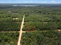
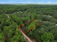
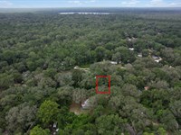
Property Location & GPS Coordinates
This beautiful property is located in Apache County in east-central Arizona, positioned in the scenic White Mountains region near the community of Concho. The area offers a genuine four-season mountain climate, abundant wildlife, excellent outdoor recreation, and escape from the desert heat. Use these precise GPS coordinates to locate and explore your property:
Decimal Degree Format:
Center Point: 34.435100, -109.606300
Northwest Corner: 34.434900, -109.606800
Northeast Corner: 34.435300, -109.606800
Southwest Corner: 34.434900, -109.605800
Southeast Corner: 34.435300, -109.605800
These coordinates enable you to precisely identify your property boundaries using GPS devices, smartphone mapping applications like Google Maps, or professional surveying equipment.
Recommendation:
For those comfortable with remote driving and beautiful scenery, the Us-60 route is superior - shorter, more direct, and incredibly scenic through mountains. For those preferring more services, take I-40.
About the White Mountains Region
The White Mountains of Arizona represent one of the Southwest's premier outdoor recreation destinations, offering a dramatic contrast to the desert landscapes most people associate with Arizona.
Location & Geography
Regional Setting:
East-central Arizona
Apache County
Part of White Mountain Apache Reservation and Apache-Sitgreaves National Forests
Colorado Plateau transition zone
Elevation range: 5,000-11,000+ feet
Landscape Features:
Mountain meadows and grasslands
Ponderosa pine forests
Aspen groves (fall colors.)
Alpine lakes and streams
Rolling hills and valleys
Volcanic peaks and formations
Wide-open vistas
Climate - Four True Seasons
Summer (June-August):
Daytime: 75-85°F (vs. Phoenix's 110-115°F.)
Nighttime: 50-60°F
Afternoon monsoon thunderstorms (dramatic.)
Perfect escape from desert heat
Comfortable outdoor activities
Cool nights for sleeping
Fall (September-November):
Daytime: 60-75°F
Nighttime: 35-50°F
Spectacular autumn colors (aspen groves turn gold)
Clear, crisp air
Ideal hiking weather
Comfortable and beautiful
Winter (December-February):
Daytime: 40-55°F
Nighttime: 15-30°F
Snow possible (creates winter wonderland)
Winter sports available
Cozy fireplace weather
True winter experience
Spring (March-May):
Daytime: 55-70°F
Nighttime: 30-45°F
Wildflowers bloom
Fresh, clean air
Snow melts, streams flow
Perfect for outdoor projects
Annual Precipitation:
15-20 inches (more than Phoenix's 8 inches)
Summer monsoon rains
Winter snow and rain
More moisture supports forests
Why People Love the White Mountains
Summer Escape from Heat:
Phoenix residents flock here in summer
30-35°F cooler than desert
Comfortable outdoor living
No air conditioning needed.
Outdoor Recreation Paradise:
World-class fishing
Excellent hunting
Hiking and camping
Mountain biking
Horseback riding
Winter sports
Wildlife viewing
Quality of Life:
Clean, fresh mountain air
Low humidity
Dark skies for stargazing
Peaceful, quiet environment
Friendly small-town communities
Lower cost of living than Phoenix
Investment Appeal:
Limited land availability
Growing popularity
Phoenix population seeks mountain retreats
Vacation rental potential
Long-term appreciation
What Makes This 1-Acre Property Special?
Perfect Size for Multiple Uses
One acre (43,560 square feet) provides:
Adequate space for comfortable home
Room for outbuildings - garage, workshop, storage
Privacy from neighbors
Garden area for growing food
RV parking and vehicle storage
Outdoor living spaces - fire pit, patio
Future expansion possibilities
Not too big - manageable and affordable
Not too small - room to breathe
Exceptional Value
Cash Price Analysis:
$8,499 for 1 acre $8,499 per acre
Extremely affordable for White Mountains region
Less than cost of a used car
Minimal financial barrier
Perfect for first-time land buyers
Financing Analysis:
$129 down payment (incredibly low.)
$129 per month (less than many phone bills.)
Total: $9,637 over 6 years
Still exceptional value
Build equity from day one
Carrying Costs:
Annual taxes: $11.40 (virtually free.)
No HOA fees
No covenants or restrictions
Total annual cost: ~$11.40 plus financing if applicable
One of lowest carrying costs anywhere
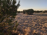
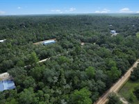
Natural Setting & Features
Environment:
High mountain elevation (~6,350 feet)
Natural high desert/mountain vegetation
Juniper and pinyon pine trees nearby
Open meadow characteristics
Big sky country
Clean, fresh air
Dark skies for stargazing
Wildlife:
Elk - large herds migrate through area
Mule deer - commonly seen
Wild turkeys - often spotted
Pronghorn antelope - in open areas
Coyotes and foxes - hear them at night
Hawks and eagles - soaring overhead
Ravens and other birds - diverse species
Jackrabbits and cottontails - abundant
Scenic Beauty:
Mountain views in distance
Wide-open spaces
Stunning sunrises and sunsets
Four-season beauty
Dramatic cloud formations
Star-filled night skies
Peaceful, serene setting
Location Advantages
Proximity to Communities:
St. Johns (12-15 miles): Apache County seat
Grocery stores
Gas stations
Medical clinic
Banks and services
Schools
Springerville-Eagar (30-35 miles): Larger mountain town
Safeway grocery
Medical center
Restaurants
Hardware stores
Building supplies
Access to Recreation:
Apache-Sitgreaves National Forests: Nearby
2+ million acres of public land
Hiking, camping, fishing, hunting
Off-road trails
Big Lake Recreation Area: ~45 miles
Sunrise Ski Park: ~50 miles
Concho Lake: Local fishing
Lyman Lake State Park: ~30 miles
Major Cities:
Phoenix: 220 miles (3.5 hours)
Flagstaff: 168 miles (2.75 hours)
Albuquerque: 210 miles (3.25 hours via Us-60)
Las Vegas: 395 miles (6 hours)
Possible Uses for Your Property
Primary or Retirement Residence
Year-Round Living:
Build your dream mountain home
Escape desert heat permanently
Four-season lifestyle
Peaceful rural environment
Near services but away from crowds
Affordable mountain living
Retirement Paradise:
Cool summers (no AC needed.)
Comfortable year-round climate
Outdoor recreation at your doorstep
Lower cost of living than Phoenix
Medical services in Springerville
Friendly community
Dark skies, clean air, peace and quiet
Weekend Getaway & Recreation
Summer Escape:
Weekend retreat from Phoenix heat
Base camp for outdoor adventures
Family gathering place
Camping and outdoor living
Build cabin over time
RV camping while developing
Outdoor Recreation Base:
Fishing: Lakes and streams nearby
Hunting: Excellent elk, deer, turkey hunting
Hiking: National Forest trails
Wildlife viewing: Year-round opportunities
Photography: Four-season beauty
Stargazing: Dark sky location
Investment & Development
Build and Hold:
Construct cabin or home
Vacation rental potential (Airbnb/VRBO)
Phoenix visitors seek mountain escapes
Long-term appreciation
Minimal carrying costs ($11.40/Year.)
Land Banking:
Hold for future use
Build equity if financing
White Mountains in high demand
Limited land availability
Pass to future generations
Retirement planning
Off-Grid or Homesteading
Self-Sufficient Living:
Solar power (excellent sun exposure)
Well water (check local depths)
Septic system
Propane for heating/cooking
Garden and small livestock (verify regulations)
True independence and freedom
Building & Development
Utilities & Services
Electricity:
Check with Navopache Electric Cooperative
Grid power may be available
Off-grid solar highly viable:
300+ sunny days per year
System costs: $15,000-$35,000 for whole house
Battery backup systems
Generator backup option
Many rural residents successfully off-grid
Water:
Well drilling standard in area
Typical depths: 200-500 feet (varies by location)
Cost: $25-$50 per foot plus equipment
Total well cost: $8,000-$20,000 typically
Water quality generally good
Water testing recommended
Hauled water option during development
Waste Management:
Septic system required for permanent residence
Standard septic: $8,000-$15,000
Apache County Health Department permits
Professional installation recommended
Soil testing for septic suitability
Internet & Communications:
Satellite internet available everywhere
Starlink - high-speed rural service
HughesNet and Viasat also available
Cell service varies by carrier and location
AT&T and Verizon generally best in rural Arizona
Signal boosters can improve reception
Landline may be available (check local providers)
Building Regulations
Apache County Requirements:
Contact Apache County Planning & Zoning:
Building permits required for most structures
Setback requirements apply
Manufactured/mobile homes allowed with permits
RV placement regulations (temporary vs. permanent)
Research specific requirements for your plans
Climate Considerations:
Design for four seasons
Good insulation for winter cold
Ventilation for summer
Snow load requirements for roof
Foundation frost depth requirements
Wood stove or fireplace popular
Propane heating common
Solar orientation for passive heating/cooling
Structure Options:
Site-Built Home:
Custom design for mountain climate
Local contractors available
$150-$250+ per square foot
Permanent, high-quality construction
Manufactured/Mobile Home:
Cost-effective option
Modern quality construction
Proper foundation and anchoring required
$60,000-$150,000 installed
Check county regulations
Cabin:
Weekend retreat or starter
Can build in phases
DIY-friendly options
$40,000-$100,000 depending on size
RV or Park Model:
Immediate occupancy
Check county regulations
Can live while building
Temporary or permanent (verify rules)
Recreation & Outdoor Activities
On Your 1-Acre Property
Camping - sleep under the stars
Stargazing - Milky Way clearly visible
Wildlife watching - elk, deer, turkeys
Photography - four-season beauty
Gardening - high-altitude growing
Outdoor cooking - fire pit, barbecue
Target practice - safe distances (follow all safety protocols)
Nature study - mountain ecosystem
Relaxation - peace and quiet
Family gatherings - create memories
Regional Recreation
Apache-Sitgreaves National Forests:
2+ million acres of public land
Hiking trails - hundreds of miles
Camping - developed and primitive sites
Fishing - lakes and streams with trout
Hunting - elk, deer, turkey, bear
Off-road trails - ATVs and motorcycles
Horseback riding - scenic trails
Wildlife viewing - diverse species
Photography - stunning landscapes
Fishing Opportunities:
Excellent fishing within driving distance:
Big Lake - rainbow and brook trout, boat ramp
Crescent Lake - rainbow trout
Mexican Hat Lake - high-elevation fishing
Little Colorado River - stream fishing
Concho Lake - local fishing spot
Numerous small lakes throughout National Forest
Ice fishing in winter months
Hunting Excellence:
The White Mountains are legendary for hunting:
Elk - Units 1 and 27 are world-renowned
Trophy bull opportunities
Archery, rifle, and muzzleloader seasons
Mule deer - good populations
Wild turkey - spring and fall seasons
Black bear - limited tags available
Mountain lion - by tag
Small game - rabbits, squirrels
Arizona Game & Fish licenses required
Draw system for elk and some deer tags
Winter Recreation:
Sunrise Ski Park - downhill skiing and snowboarding
Cross-country skiing - National Forest trails
Snowshoeing - explore winter wonderland
Snowmobiling - designated trail systems
Ice fishing - frozen lakes
Winter camping - for the adventurous
Scenic Attractions:
Coronado Trail (Us-191) - one of America's most scenic drives
Mogollon Rim - 200-Mile escarpment
Alpine - Arizona's highest incorporated town
Petrified Forest National Park - ~70 miles north
Historic sites - Native American ruins, old settlements
Nearby Communities
St. Johns (12-15 miles):
Apache County seat
Population: ~3,500
Services:
Grocery stores
Gas stations
Restaurants
Medical clinic
Post office
Banks
Library
Schools
Historic downtown
Community events
Springerville-Eagar (30-35 miles):
Combined population: ~5,000
Gateway to White Mountains
Full Services:
Safeway grocery store
White Mountain Regional Medical Center
Restaurants and cafes
Hardware stores (True Value)
Building supply stores
Hotels and lodging
Casa Malpais archaeological site
Round Valley area
Getting Started with Purchase
Simple Purchase Process
Cash Purchase ($8,499):
Review Property
Visit
Review all photos, maps, and information
Explore using GPS coordinates on Google Earth
Contact Us
Call or email with questions
Discuss property details
Schedule property visit if desired
Visit Property (Highly Recommended)
Use detailed directions and GPS coordinates
Walk property boundaries
Take photos and videos
Experience the area
Envision your plans
Purchase Agreement
Simple, straightforward paperwork
Review all terms carefully
Sign and return
Quick Closing
Efficient closing process
Minimal hassle
Title transferred to you
Receive Deed
Warranty deed recorded in Apache County
You're a White Mountains landowner.
Owner Financing ($129 down, $129/Month for 72 months):
Initial Contact
Discuss property and financing terms
Ask any questions
No credit check required.
Simple Application
Basic information only
Quick approval
No complicated process
Down Payment
$129 down payment
$250 document fee (one-time)
Total initial: $379
Sign Agreement
Clear, straightforward terms
No hidden fees
Monthly payment: $129
Begin Payments
72 easy monthly payments
Build equity with each payment
Own property from day one
Immediate usage rights
Receive Full Deed
Upon completion of 72 payments
Free and clear ownership
Warranty deed in your name
Due Diligence
Visit the Property:
See it in person if possible
Walk boundaries using GPS coordinates
Experience area and climate
Take photos and videos
Check access routes
Talk to neighbors if available
Research:
Contact Apache County Planning & Zoning
Verify building requirements
Check utility availability and costs
Confirm current tax information
Review flood maps (typically low risk at elevation)
Research well depths in specific area
Verify road access and maintenance
Professional Services (Optional):
Survey for exact boundaries: $1,500-$2,500
Title insurance for protection: $800-$1,200
Soil testing if planning septic: $500-$1,500
Well feasibility study: $300-$1,000
Online Research:
Google Earth for aerial views
USGS topographic maps
Arizona Game & Fish (hunting info)
Apache-Sitgreaves National Forests maps
Weather data for area
Apache County website
What to Bring When Visiting
Essential Items:
GPS device or smartphone with offline maps
Property GPS coordinates
Camera and video recorder
Water (1+ gallon per person minimum)
Snacks and food
Full tank of gas
Appropriate clothing for season
Layers (temperature swings common)
Sun protection (hat, sunscreen, sunglasses)
First aid kit
Spare tire and basic tools
Flashlight or headlamp
Binoculars for wildlife viewing
Compass
Paper maps as backup
Notebook for observations
Seasonal Considerations:
Summer: Light layers, rain gear for monsoons, sun protection
Winter: Warm clothing, possible snow gear, check road conditions
Spring: Layers for variable temps, possible mud
Fall: Warm layers, ideal weather usually
Safety Tips:
Tell someone your plans and expected return
Check weather forecast
Carry extra supplies
Watch for wildlife (elk can be large.)
Be aware of afternoon thunderstorms (summer)
Cell service may be limited
Download offline maps
Respect private property
Stay on designated roads
Winter: Carry chains, check conditions
Frequently Asked Questions
Q: What can I build on 1 acre?
A: One acre can accommodate a single-family home, manufactured home, cabin, garage, workshop, and outbuildings. Contact Apache County Planning for specific zoning regulations.
Q: Is water available?
A: You'll need to drill a well. Typical depths are 200-500 feet in the area. Contact local well drillers for specific estimates.
Q: How much snow does it get?
A: The area receives moderate snowfall (20-40 inches annually on average). Snow usually melts within days, but true winter conditions do occur.
Q: Can I live there year-round?
A: Yes, with a properly permitted structure. You'll need well water, septic system, and heating for winter months.
Q: What about electricity?
A: Contact Navopache Electric Cooperative for grid availability. Off-grid solar is also very viable with 300+ sunny days annually.
Q: Is this good hunting land?
A: The property is in excellent hunting territory. The White Mountains are famous for elk hunting. You can hunt on your property with proper licenses, and vast public lands are nearby.
Q: How far to stores?
A: St. Johns (12-15 miles) has grocery stores. Springerville (30-35 miles) has a Safeway and more options.
Q: What's the nearest hospital?
A: White Mountain Regional Medical Center in Springerville-Eagar (approximately 30-35 miles).
Q: Can I pay off financing early?
A: Yes. Early payoff allowed with no prepayment penalties. Contact us for current payoff balance.
Q: Why are taxes so low?
A: Arizona taxes vacant land at very low rates. Once you build, taxes increase based on improvements but remain reasonable.
Q: Is this a good investment?
A: The White Mountains are highly desirable for summer recreation and retirement. Low carrying costs ($11.40/Year taxes) make long-term holding very affordable.
Q: What wildlife will I see?
A: Elk (common in large herds), mule deer, wild turkeys, coyotes, foxes, hawks, eagles, and various other species.
Q: Can I camp on the property?
A: Check Apache County regulations for temporary camping. Many owners camp while developing their property.
Q: Is owner financing really no credit check?
A: Yes. We don't check credit. If you can make the payments, the property is yours.
Q: Are there HOA fees?
A: No Hoa, no covenants, no restrictions beyond county regulations. Freedom to use your property as you wish.
Q: How's cell phone service?
A: Varies by carrier and exact location. At&T and Verizon generally have best rural coverage. Signal boosters help.
Q: Can I see the Milky Way?
A: Absolutely. With minimal light pollution, night skies are spectacular. Perfect for stargazing and astrophotography.
Why Choose H5 Land Ventures?
Our Commitment:
Transparent Pricing - No hidden fees or surprises
Accurate Information - GPS coordinates and honest descriptions
Accessible Financing - No credit check, ultra-affordable terms
Quality Properties - Carefully selected parcels in desirable areas
Responsive Service - We're here to help and answer questions
Simple Process - Quick, efficient closings
Fair Terms - No prepayment penalties
Customer Success - We want you to love your land
Your White Mountains Dream Starts Here
This exceptional 1-acre property in Apache County represents outstanding value in one of Arizona's most desirable mountain regions. Whether you're seeking escape from Phoenix heat, a retirement property, hunting base, investment opportunity, or year-round mountain living, this property delivers at an incredibly affordable price.
Property Summary:
Location: Apache County, Arizona (White Mountains region)
Apn: 201-28-065
Size: 1 acre (43,560 square feet)
Cash Price: $8,499
Owner Financing: $129 down + $250 fee, then $129/Month for 72 months
Annual Taxes: Only $11.40.
Elevation: ~6,350 feet
GPS Center: 34.435100, -109.606300
Why This Property Stands Out:
Perfect 1-acre size
Ultra-affordable pricing
Flexible financing ($129 down.)
Four-season mountain climate
Cool summers (30°F cooler than Phoenix.)
World-class elk hunting area
Excellent fishing nearby
Apache-Sitgreaves National Forests access
Wildlife viewing (elk, deer, turkeys)
Dark skies for stargazing
Virtually free taxes ($11.40/Year)
Investment potential
Peaceful mountain living
Visit our website:
Don't miss this opportunity to own 1 acre in Arizona's beautiful White Mountains. Contact us today.
Your White Mountains retreat awaits. Make it yours today.
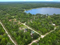
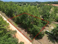
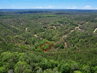
Land Maps
Directions to Land
Detailed Directions to the Property
From Phoenix, Arizona (Approximately 215 miles, 3 hours 30 minutes)
Phoenix provides excellent access to your White Mountains property via major highways.
Route via US-60 E (Primary and Most Scenic Route):
Start in Phoenix
Downtown Phoenix or East Valley areas
Access US-60 E (Superstition Freeway)
Take US-60 E from Phoenix
Head east through Mesa, Gilbert, and Apache Junction
Begin climbing out of the Sonoran Desert
Pass through Gold Canyon area
Continue on US-60 E through mountain country (~180 miles total on US-60)
Major landmarks and stops:
Early Section (Phoenix to Superior, 60 miles):
Apache Junction (mile 20): Last major Phoenix suburb
Gas, food, shopping
Gateway to Superstition Mountains
Lost Dutchman State Park: Superstition Mountains access
Queen Creek Tunnel: Elevation gain begins
Superior (mile 60): Historic mining town
Gas and basic services
Boyce Thompson Arboretum nearby
Dramatic cliff scenery
Middle Section (Superior to Show Low, 120 miles):
Globe-Miami (mile 75): Historic copper mining towns
Gas, food, services available
Restaurants and convenience stores
Salt River Canyon (mile 105): Spectacular canyon crossing
One of most scenic sections
2,000-foot descent then climb
Rest area with views
Bridge over Salt River
Watch for sharp curves
Carrizo (mile 120): Small community
Hon-Dah (mile 140): Apache reservation
Hon-Dah Resort Casino
Gas and services
Show Low (mile 150): Major mountain town
Recommended stop for fuel and supplies
Full services available:
Gas stations (multiple)
Grocery stores (Safeway, Walmart)
Restaurants (chains and local)
Hotels and lodging
Medical facilities
Cool mountain climate (7,000 feet)
Final Section (Show Low to Property Area, 65 miles):
Continue east on US-60 from Show Low
Pass through Pinetop-Lakeside
Beautiful pine forests
Resort communities
More services available
Springerville-Eagar area (mile 185): Near property
Services available
White Mountain Apache Reservation boundary
Navigate to Concho area
From US-60, head toward Concho
Concho is south of US-60
Use GPS coordinates (34.423917, -109.582528) for exact navigation
Access via local roads to property
What Makes This Drive Special:
Elevation Change:
Start: Phoenix at 1,100 feet
End: Property area at 6,400 feet
Total climb: Over 5,000 feet.
Experience multiple climate zones
Scenic Highlights:
Superstition Mountains - rugged desert peaks
Salt River Canyon - "Mini Grand Canyon"
Mogollon Rim - dramatic escarpment
Ponderosa pine forests
White Mountains scenery
Wildlife viewing opportunities
Climate Transition:
Desert (Phoenix) ? High Desert ? Chaparral ? Pine Forest ? Mountain Meadows
Temperature drops 20-30°F from Phoenix to property
Dramatic vegetation changes
Services Along Route:
Phoenix: All metropolitan services
Apache Junction (20 miles): Full services
Superior (60 miles): Gas, food, basic services
Globe (75 miles): Full small-town services
Show Low (150 miles): Major stop - full services
Pinetop-Lakeside (165 miles): Full resort town services
Springerville-Eagar (185 miles): Services near property
Travel Tips:
Fuel: Fill up in Show Low or Pinetop-Lakeside
Timing: Allow 3.5-4 hours with stops
Summer: Much cooler at property than Phoenix (perfect escape.)
Winter: Snow possible on US-60 east of Payson, check conditions
Salt River Canyon: Watch for curves, enjoy views
Best seasons: Year-round access, spring and fall ideal
From Flagstaff, Arizona (Approximately 165 miles, 2 hours 45 minutes)
Flagstaff provides northern access to the property through beautiful high country.
Route via I-40 E and US-180/191 S (Recommended Route):
Start in Flagstaff
Downtown or I-40 corridor
Elevation 6,910 feet
Take I-40 E from Flagstaff
Head east toward Winslow
High plateau scenery
Continue on I-40 E (approximately 55 miles)
Pass through Winona
Reach Winslow
"Standin' on the Corner" park
Services available if needed
Continue to Holbrook (mile 90 from Flagstaff)
Gas and food available
Petrified Forest National Park nearby
Take US-180 S from Holbrook (or alternate via St. Johns)
Head south toward St. Johns and Alpine
Beautiful high desert and mountain scenery
Via St. Johns Route:
From I-40, can take SR-61 S to St. Johns
St. Johns has services
Continue to Concho area from St. Johns (about 15 miles)
Navigate to Concho area
From St. Johns, head to Concho
Use GPS coordinates (34.423917, -109.582528)
Access via local roads
Alternative Route via Show Low:
From Flagstaff, take SR-87 S to Payson
Then SR-260 E to Show Low
Then US-60 E toward Springerville
Head to Concho from US-60
Longer but very scenic through pine forests
Flagstaff Area:
Full services and amenities
Mountain town atmosphere
Cool climate year-round
Excellent base for visiting property
Timing:
Driving time: 2 hours 45 minutes to 3 hours 15 minutes
Distance: Approximately 165 miles
Year-round access: Generally good, winter snow possible
From Las Vegas, Nevada (Approximately 395 miles, 6 hours)
Las Vegas provides western access via scenic routes through Arizona.
Route via I-40 E and US-180 S (Primary Route):
Start in Las Vegas
Downtown or Strip area
Take US-93 S or I-11 S toward Arizona
Head toward Arizona via US-93 S
Pass through Boulder City
Optional: Hoover Dam detour
Cross into Arizona
Continue to Kingman area
Connect to I-40 E at Kingman (approximately 105 miles from Vegas)
Kingman has full services
Historic Route 66 town
Good stop for fuel
Take I-40 E across northern Arizona (approximately 235 miles)
Major stops:
Seligman (mile 155 from Vegas): Route 66 character
Williams (mile 185): Grand Canyon gateway, services
Flagstaff (mile 220): Major city, full services
Winslow (mile 275): Services available
Holbrook (mile 310): Services, near Petrified Forest
From Holbrook area, head south
Take US-180 S or route via St. Johns
Head toward Concho area
Continue as described in Flagstaff directions
Navigate to property
Use GPS coordinates (34.423917, -109.582528)
Access via local roads
Services:
Las Vegas: All metropolitan services
Kingman (105 miles): Full services
Flagstaff (220 miles): Major services
Holbrook (310 miles): Services available
Timing:
Total time: 6 to 6.5 hours with stops
Distance: Approximately 395 miles
Interstate driving: Most of route on I-40
From Albuquerque, New Mexico (Approximately 220 miles, 3 hours 30 minutes)
Albuquerque provides the easiest access from the east through beautiful New Mexico high country.
Route via I-40 W and US-60 W (Primary Route):
Start in Albuquerque
Downtown or I-25/I-40 interchange
Elevation 5,312 feet
Head west on I-40 W
Leave Albuquerque metro area
Cross Rio Grande
Begin journey across New Mexico
Continue west on I-40 W (approximately 140 miles in New Mexico)
Major stops in New Mexico:
Laguna Pueblo (mile 45): Casino, limited services
Grants (mile 80): Full services
Gas, food, hotels
Good mid-route stop
Continental Divide (mile 105): Elevation 7,275 feet
Rest area
Watershed divide
Gallup (mile 140): Last major New Mexico city
Recommended stop
Full services
Native American arts and crafts
Route 66 heritage
Cross into Arizona (just west of Gallup)
Enter Apache County, Arizona
Continue west on I-40
Continue on I-40 W in Arizona
Pass through Chambers, Sanders
High desert plateau scenery
Alternative Direct Route via US-60:
From Socorro, NM (south of Albuquerque)
Take US-60 W directly to Arizona
This is actually more direct to Concho area
Passes through:
Magdalena, NM
Datil, NM
Quemado, NM
Springerville, AZ
Very scenic but more remote
Limited services along route
Recommended for experienced travelers
Via US-60 from Socorro:
From Albuquerque, take I-25 S to Socorro (75 miles)
Take US-60 W from Socorro
Continue through New Mexico mountains
Cross into Arizona near Springerville
Concho is just west of Springerville area
Much more direct route.
Distance: ~220 miles
Time: 3.5-4 hours
Very scenic but remote
Services:
I-40 Route:
Albuquerque: All services
Grants (80 miles): Full services
Gallup (140 miles): Full services
US-60 Route:
Socorro: Full services (fuel up here.)
Magdalena: Limited services
Datil: Very limited
Quemado: Limited services
Springerville: Full services
Timing:
I-40 route: 4 to 4.5 hours
US-60 route: 3.5 to 4 hours (more direct)
US-60 is more scenic but remote
Recommendation:
For first-time visitors, I-40 route is safer with more services. For those comfortable with remote driving, US-60 is more direct and incredibly scenic through mountains and high desert.
More Land Details
More Land from David Healy
 0.2 AC : $15K
- 0.4 AC : $15K
- 3 AC : $19K
- 0.2 AC : $7.5K
- 0.6 AC : $38K
- 0.5 AC : $30K
- 0.2 AC : $16K
- 0.4 AC : $20K
- 1.3 AC : $8K
- 0.2 AC : $10K
- 0.2 AC : $9K
- 0.2 AC : $16K