Affordable High Desert Paradise
Cayuse Lane : Concho, AZ 85924
Apache County, Arizona
Land Description
Your Affordable High Desert Paradise - 1.32 Acres Near Concho in Apache County, Arizona
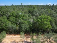
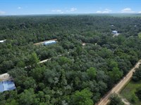
Discover the authentic beauty and unlimited potential of northeastern Arizona with this exceptional 1.10-Acre parcel, ideally situated near the charming community of Concho in Apache County's pristine high desert landscape. This property represents an outstanding opportunity to own over an acre of genuine Western terrain at an incredibly affordable price, where endless skies meet sweeping grasslands and the pioneering spirit of the frontier remains vibrantly alive.
Property Identification:
APN Number: 201-40-123C
Total Acreage: 1.32 acres
County: Apache County, Arizona
State: Arizona
Location: Near Concho, Apache County high desert region
Pricing & Payment Options
We've designed flexible purchasing options to make land ownership accessible and affordable for everyone:
Cash Purchase Option:
Total Price: $8,000
Pay in full and own your land outright immediately
No monthly obligations or ongoing payments
Instant complete ownership and equity
Best overall value with no financing costs
Less than the cost of most used vehicles
Owner Financing Option:
Down Payment: $150
Document Fee: $250 (one-time processing fee)
Monthly Payment: $150
Term: 60 months (5 years)
Total Financed Amount: $9,000 + $400 initial $9,400
No credit checks or bank qualification required
Simple, straightforward application process
Fast approval and quick closing
No prepayment penalties - pay off early and save
Annual Property Taxes:
Total Annual Tax: $10.40
Among the absolute lowest property tax rates in the United States
Less than $0.87 per month in total taxes
Minimal carrying costs for long-term holding
Lower than most monthly streaming service subscriptions
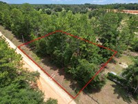
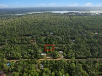
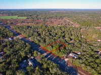
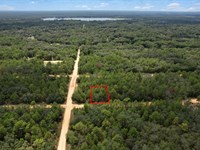
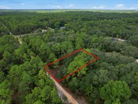
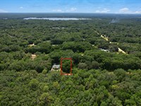
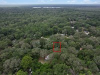
Precise Property Coordinates
Navigate directly to your future property using these exact GPS coordinates:
Center Point: 34.426000, -109.584700
Northwest Corner: 34.426200, -109.585300
Northeast Corner: 34.426200, -109.584300
Southwest Corner: 34.425500, -109.584300
Southeast Corner: 34.425900, -109.585300
These precise coordinates enable you to explore the property virtually using Google Earth, Google Maps, or any Gps-Enabled device before visiting in person. Simply enter the coordinates into your preferred mapping application to view satellite imagery, terrain features, topography, and the surrounding area in exceptional detail.
Location & Area Description
Apache County & Concho Area
Apache County represents one of Arizona's most authentic and unspoiled regions, preserving the genuine character of the Old West. As the state's third-largest county by area, encompassing over 11,218 square miles (larger than the entire state of Massachusetts or the country of Belgium), it offers incredibly diverse terrain ranging from high desert plains to forested mountains reaching over 11,000 feet elevation at Mount Baldy.
About Concho:
Concho is a small, peaceful unincorporated community in Apache County with a population of approximately 50-100 residents who value privacy, independence, and the wide-open spaces of rural Arizona. The community sits at approximately 6,000 feet elevation in the transition zone between the White Mountains to the south and the high desert plains to the north.
Originally established as a Mormon farming settlement in the late 1800S, Concho maintains its rural agricultural character with ranches, small farms, and homesteads scattered across the landscape. The community offers a genuine small-town atmosphere where neighbors know each other, help each other, and value traditional Western values of self-reliance and independence.
Your property near Concho provides the perfect balance of privacy and accessibility - remote enough for peace, quiet, and dark skies, yet close enough to services in nearby Springerville and St. Johns for convenience.
Elevation & Climate:
The property sits at approximately 6,000 feet above sea level, placing it in Arizona's high desert climatic zone. This elevation provides a dramatically different and significantly more comfortable climate than Arizona's famous low desert regions:
Summer Temperatures: Daytime highs typically range from 75-85°F with refreshingly cool nights dropping to 45-55°F. Unlike Phoenix's brutal triple-digit summers regularly exceeding 110°F, this elevation offers genuinely pleasant conditions perfect for outdoor activities, camping, building, and comfortable living without expensive air conditioning.
Winter Temperatures: Daytime highs average 35-45°F with nighttime lows of 10-25°F. Cold but manageable with proper preparation, appropriate clothing, and adequate heating. Winter days are often sunny and pleasant.
Spring/Fall Temperatures: Perfect shoulder seasons with daytime temperatures ranging comfortably from 50-70°F and ideal conditions for hiking, camping, building projects, and outdoor exploration.
Annual Precipitation: Approximately 10-12 inches per year, with most moisture arriving from dramatic summer monsoon thunderstorms (July-August) bringing afternoon and evening storms, and winter snow events providing beautiful winter landscapes.
Snowfall: Light to moderate snow possible from December through March, typically accumulating 10-20 inches annually but usually melting within several days to a week, rarely causing extended access issues.
Humidity: Very low year-round, typically 15-30%, making both hot and cold temperatures more comfortable and bearable than humid climates. The dry air means 80°F feels pleasant rather than oppressive.
Wind: Moderate winds common throughout the year, especially noticeable during spring months (March-May) when sustained breezes can reach 15-25 mph, providing natural cooling and excellent wind energy potential.
Seasonal Highlights: Four distinct seasons with spectacular monsoon thunderstorms featuring dramatic lightning displays, torrential downpours, and magnificent double rainbows in summer; crystal-clear, star-filled winter nights perfect for stargazing when the Milky Way appears in stunning detail; and brilliant fall colors in nearby mountains.
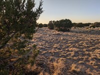
Natural Environment & Wildlife
The property is situated in a pristine high desert ecosystem characterized by remarkable biodiversity, stunning natural beauty, and relatively undisturbed habitat:
Vegetation:
Sagebrush (Artemisia tridentata): The dominant shrub species covering vast areas with aromatic silvery-green foliage that releases its distinctive, pleasant scent after rain showers
Native Grasses: Blue grama, Indian ricegrass, galleta grass, buffalo grass, and other species providing year-round ground cover and important forage for wildlife and livestock
Juniper Trees: One-seed juniper and Utah juniper scattered across the landscape providing vertical interest, shade, nesting sites for birds, and critical wildlife habitat
Chamisa (Rabbitbrush): Adding brilliant golden-yellow blooms in late summer and fall, creating stunning landscapes that contrast beautifully with bright blue skies and attract numerous pollinators
Four-wing Saltbush: Hardy native shrub offering year-round browse for wildlife and livestock, with distinctive four-winged seed pods
Wildflowers: Native species blooming spectacularly after spring rains and summer monsoons, including Indian paintbrush in vivid reds and oranges, lupine in purple and blue, penstemon, globe mallow, evening primrose, desert marigold, and numerous others creating carpets of color
Cacti: Prickly pear with edible fruit (tunas) and pads (nopales), and occasional cholla cactus in select microhabitats and rocky areas
Wildlife:
The Concho area supports diverse and abundant wildlife populations that make every visit an adventure in natural observation and provide excellent opportunities for wildlife photography and viewing:
Large Mammals: Mule deer with impressive antlers (bucks can exceed 200 pounds with antlers spanning 30+ inches), pronghorn antelope capable of sustained speeds exceeding 50 mph making them North America's second-fastest land animal, occasional elk migrating from nearby White Mountains forests during different seasons (bulls can weigh 700+ pounds)
Predators: Coyotes with distinctive howling calls at dawn and dusk creating the classic soundtrack of the Western wilderness, kit foxes and gray foxes, bobcats with tufted ears and spotted coats, badgers digging for ground squirrels and creating burrows, and very occasional mountain lion sightings in remote areas (these elusive cats generally avoid human contact)
Birds of Prey: Golden eagles with 7-foot wingspans soaring majestically on thermal currents, red-tailed hawks, Swainson's hawks migrating through in fall, northern harriers hunting low over grasslands with distinctive white rump patches, American kestrels (our smallest falcon), prairie falcons, and great horned owls with distinctive ear tufts hunting at night
Songbirds: Western meadowlarks with their distinctive melodious song considered one of the most beautiful bird songs in North America, horned larks, mountain bluebirds with brilliant blue plumage, sage thrashers, and numerous sparrow species including white-crowned, vesper, sage, and Brewer's sparrows
Ravens & Corvids: Common ravens performing aerial acrobatics and demonstrating remarkable intelligence (they can solve complex problems and use tools), pinyon jays traveling in noisy flocks, and black-billed magpies with striking black and white plumage and long tails
Small Mammals: Black-tailed jackrabbits with oversized ears for heat dissipation, desert cottontails, rock squirrels, Colorado chipmunks, deer mice, kangaroo rats with specialized kidneys allowing them to survive without drinking water, pocket gophers creating mounds, and various vole species
Reptiles: Various lizard species including collared lizards with vibrant blue and green colors, whiptails racing across open ground, side-blotched lizards, and horned lizards (often called "horny toads"); snakes including bull snakes (excellent rodent controllers), gopher snakes, striped whipsnakes, and occasional prairie rattlesnakes (please be aware and exercise appropriate caution, especially during warmer months from April through October)
Seasonal Visitors: Sandhill cranes during spring and fall migrations creating spectacular flyovers with their distinctive trumpeting calls, various waterfowl species using seasonal wetlands and stock ponds, numerous neotropical migrant songbirds during spring and fall including warblers and flycatchers
Dark Skies & Astronomical Excellence
One of the property's most extraordinary and valuable features is its remarkably dark night sky. With minimal light pollution from nearby communities (Concho has very few lights, and larger towns are miles away) and the crystal-clear air at 6,000 feet elevation, the property offers truly world-class stargazing opportunities that rival professional observatory sites:
Milky Way Visibility: Clearly visible stretching magnificently from horizon to horizon on moonless nights, appearing as a luminous band across the sky with incredible structural detail including dark dust lanes like the Great Rift, bright star clouds, and the brilliant galactic core visible during summer months rising in the southeast
Deep Sky Objects: Andromeda Galaxy (M31, our nearest large galactic neighbor 2.5 million light-years away) visible to the naked eye as a fuzzy patch, Orion Nebula (M42, a stellar nursery where new stars are forming) visible in winter, and countless star clusters like the Pleiades (M45, the Seven Sisters), Beehive Cluster (M44), and numerous others visible without optical aid
Planetary Viewing: Venus shining brilliantly as the "evening star" or "morning star," Mars showing its distinctive reddish color, Jupiter (with its four Galilean moons Io, Europa, Ganymede, and Callisto visible through binoculars and cloud bands visible through telescopes), and Saturn (with rings clearly visible through small telescopes and largest moon Titan visible) observable in stunning detail
Meteor Showers: Annual events visible in full glory including Perseids (August 11-13, often producing 60-100 meteors per hour at peak), Geminids (December 13-14, the year's most reliable shower), Quadrantids (January 3-4), Lyrids (April 21-22), Leonids (November 17-18), and numerous others
Aurora Borealis: Occasionally visible on the northern horizon during intense solar storms and strong geomagnetic events (Kp index 7+), something extraordinarily rare and special this far south (approximately 34° north latitude) - a once-in-a-lifetime viewing opportunity
Zodiacal Light: Faint pyramidal glow visible after sunset and before sunrise during optimal viewing times (spring evenings, fall mornings), a phenomenon created by sunlight reflecting off interplanetary dust and only visible from very dark locations far from light pollution
International Space Station: Regular highly visible passes overhead several times per week, appearing as a bright steadily moving "star" crossing the sky from horizon to horizon in just a few minutes
Satellite Observations: Excellent location for viewing Starlink satellite trains (especially dramatic shortly after launch), Iridium flares, and other orbital objects
Astrophotography: Exceptional conditions for deep sky imaging with long exposures, Milky Way photography capturing the galactic core, time-lapse cinematography, meteor shower documentation, planetary imaging, and even solar photography during the day
Nearby Communities & Essential Services
Springerville-Eagar (approximately 25 miles south):
Population: Combined approximately 6,500 residents providing genuine small-town atmosphere with essential services
Amenities: Full-service community with multiple grocery stores (Safeway, Basha's, local markets), numerous gas stations, diverse restaurants including American, Mexican, Chinese, and fast-food options, medical facilities including Round Valley Medical Center with 24-hour emergency services and urgent care
Services: Hardware stores (True Value, Ace Hardware), building supply centers, lumber yards, feed and ranch supply stores, several banks and ATMs, post office and government services, automotive repair shops and parts stores, veterinary clinics, laundromats
Education: Public schools K-12, Eastern Arizona College extension center offering associate degrees and vocational training, public library with free internet access and extensive community programs
Recreation: Gateway to White Mountains recreation including world-class trout fishing in over 30 lakes and streams, extensive hiking trails, mountain biking, Sunrise Ski Resort for winter skiing and snowboarding, camping facilities
Character: Friendly small-town atmosphere with deep ranching and farming heritage, Western values, welcoming community spirit, and annual events including rodeos and county fair
St. Johns (approximately 45 miles northwest):
Population: Approximately 3,500 residents
Role: County seat of Apache County with all major government offices and comprehensive services
Amenities: Additional shopping options including Safeway grocery, medical services, restaurants, essential services, local businesses, gas stations
Government: Apache County courthouse, planning and zoning offices, assessor, treasurer, recorder, sheriff's office, public works, and other county departments providing all government services
Healthcare: Little Colorado Medical Center providing emergency services and general medical care
Historic Interest: Founded in 1879 by Mormon pioneers, features beautifully preserved historic downtown district with 19th-century buildings constructed of local stone, Apache County Historical Society Museum showcasing territorial history, and significant architectural heritage
Concho (immediate area):
Small unincorporated community
Post office for mail service
Very limited commercial services
Strong sense of community among residents
Peaceful rural atmosphere
Agricultural heritage
Regional Attractions & Recreational Opportunities
Your property near Concho provides convenient access to numerous spectacular natural attractions and diverse recreational opportunities:
White Mountains Recreation Area (approximately 40-60 miles south):
Sunrise Ski Resort offering winter skiing/snowboarding on 65 runs and summer mountain biking on extensive trail networks
Over 30 lakes and reservoirs providing world-class trout fishing for Apache, Rainbow, Brook, and Brown trout
Hundreds of miles of hiking and mountain biking trails through alpine forests and mountain meadows
Big Lake at 9,000 feet elevation with camping, fishing, and boating
Luna Lake with excellent fishing and accessible facilities
Mount Baldy Wilderness Area featuring Arizona's second-highest peak at 11,409 feet
Elk viewing opportunities (Arizona's largest elk herd numbers over 35,000 animals)
Extensive camping facilities including developed campgrounds with amenities and dispersed primitive camping
Petrified Forest National Park (approximately 90 miles west):
346-million-year-old petrified wood forests creating landscapes unlike anywhere else on Earth
Painted Desert viewpoints offering stunning vistas of colorfully banded badlands spanning the horizon
Native American petroglyphs and archaeological sites dating back over 2,000 years
Blue Mesa and Jasper Forest trails showcasing incredible Triassic geology and paleontology
Route 66 history including the historic Painted Desert Inn, a National Historic Landmark
Wilderness area with backcountry hiking and camping opportunities
Casa Malpais Archaeological Park (St. Johns):
Ancient Mogollon pueblo ruins dating to 1250-1400 Ce
Extensive masonry structures built atop volcanic basalt
Great Kiva and ceremonial chambers
Guided tours available showcasing prehistoric architecture and culture
Museum with artifacts and interpretive displays
Lyman Lake State Park (approximately 50 miles north):
1,500-acre lake for boating, fishing, and water recreation
Camping facilities with modern amenities
Swimming beach area
Petroglyphs and archaeological sites
Wildlife viewing including waterfowl and shore birds
Year-round recreation opportunities
Land Use & Development Potential
Permitted Uses
Apache County offers relatively flexible and accommodating land use regulations for rural properties, allowing for various residential, recreational, and agricultural uses:
Residential Development:
Site-built single-family homes (traditional stick-built construction)
Manufactured homes and mobile homes (single-wide, double-wide, or triple-wide)
Recreational vehicles for temporary or permanent occupancy
Tiny homes and alternative housing structures
Cabins, cottages, and weekend retreat structures
Guest houses and accessory dwelling units
Home-based businesses that don't create nuisances
Recreational Uses:
Camping and outdoor recreation
RV parking and extended use
Hunting with proper Arizona Game & Fish licenses
Off-road vehicle recreation
Horseback riding
Photography and nature study
Stargazing and astronomy
Hiking and exploration
Agricultural Uses:
Livestock grazing with proper permits
Small-scale farming
Vegetable gardens
Beekeeping
Chicken coops and poultry
Other agricultural pursuits
Utilities & Infrastructure
Important Infrastructure Information:
This property is located in a rural area. Prospective buyers should plan accordingly:
Electricity:
Electric service may be available in the Concho area - verify with local utility provider
If not available, solar power systems are practical and cost-effective
Modern solar technology provides reliable off-grid power
Solar systems: basic $5,000-$10,000; comprehensive $15,000-$35,000+
Water:
No municipal water service
Well drilling possible with typical depths 300-500 feet in Concho area
Water hauling available for temporary use
Rainwater harvesting potential
Consult local well drillers about availability and costs before purchasing
Well drilling costs typically $15,000-$35,000+
Septic/Sewer:
No municipal sewer
Septic systems required for permanent dwellings
County permits and soil testing required
Installation costs typically $5,000-$15,000
Composting toilets alternative for cabins
Internet/Communications:
Satellite internet available (Starlink recommended)
Cell service varies by carrier
Landline may be available - verify with provider
Roads:
Property accessed via county and local roads
Road conditions vary
High-clearance vehicle recommended
Roads generally maintained
Building Considerations
Permits & Regulations:
Contact Apache County Planning & Zoning:
Building permits required for structures
Verify current requirements for your plans
Setback requirements apply
Construction Recommendations:
Design for high desert climate
Passive solar design
Excellent insulation
Wind resistance
Fire-resistant materials
Proper drainage
Investment Potential
Apache County & Concho Area Advantages
Exceptional Affordability:
Only $8,000 cash for 1.32 acres
Or $150/Month for just 5 years
Annual taxes only $10.40
No HOA fees
Extremely low carrying costs
Strategic Location:
Near small community of Concho
25 miles to Springerville services
Access to White Mountains recreation
Four-season climate
Dark skies for stargazing
Future Growth Potential:
Arizona's continued population growth
Increasing demand for rural properties
Limited affordable land supply
Growing interest in off-grid living
Retirement destination appeal
Why Choose This Property?
Unique Advantages
Over One Acre:
1.10 acres provides ample space
Room for home, RV, outbuildings
Privacy and breathing room
Garden and livestock potential
Multiple use possibilities
Incredible Affordability:
Only $8,000 cash - less than many used cars
Or $150/Month - less than typical car payments
$10.40 annual taxes - less than $1 per month
No hidden fees or costs
Immediate equity building
Near Concho Community:
Small peaceful community nearby
Sense of rural neighborhood
Still private and quiet
Balance of solitude and community
Agricultural heritage area
Owner Financing Benefits:
No credit check
Simple approval
Low down payment ($150)
Affordable monthly payment
No prepayment penalty
Clear path to ownership in 5 years
Perfect For Multiple Uses
Weekend Recreation:
Camp under dark skies
Base for White Mountains exploration
Hunting and outdoor activities
Photography opportunities
Peaceful getaway
Future Retirement:
Secure affordable land now
Build equity over time
Plan dream retirement
Low taxes and costs
Comfortable climate
Off-Grid Living:
Sustainable living potential
Solar power options
Water self-sufficiency
Grow food
Live your values
Investment:
Affordable entry point
Appreciation potential
Low holding costs
Tangible asset
Portfolio diversification
Small Homestead:
Chickens and small livestock
Vegetable garden
Self-sufficiency
Rural lifestyle
Agricultural pursuits
Due Diligence Recommendations
We strongly encourage comprehensive due diligence:
Visit the Property:
Use GPS coordinates (34.426000, -109.584700)
Walk the property
Check access
Observe surroundings
Visit Concho area
Research & Verification:
Contact Apache County Planning & Zoning
Verify zoning and uses
Check building requirements
Review tax records
Research utilities availability in Concho area
Contact local well drillers
Financial Planning:
Calculate total costs
Budget for development
Plan for utilities
Consider construction costs
Establish reserves
How to Purchase
Simple Purchase Process
Step 1: Choose Payment Method
Cash: $8,000 total
Financing: $150 down + $250 doc fee, then $150/Month for 60 months
Step 2: Contact Us
Visit:
Step 3: Complete Documentation
Review purchase agreement
Provide identification
Arrange payment
Step 4: Take Ownership
Deed recorded (cash) or held in trust (financing)
Receive documents
Take possession
Start your adventure
Owner Financing Details
No Credit Check:
Past credit issues not a barrier
Focus on current ability
Simple Qualifying:
Proof of identity
Contact information
Down payment and doc fee
Flexible Terms:
$150 down
$250 document fee
$150/month for 60 months
No prepayment penalty
5 years to ownership
Frequently Asked Questions
Q: How big is 1.32 acres?
A: Approximately 57499.2 square feet - plenty of room for home, RV, garden, outbuildings, and privacy.
Q: What's Concho like?
A: Small, peaceful unincorporated community with approximately 50-100 residents, rural agricultural character, and friendly atmosphere.
Q: How far to services?
A: Springerville-Eagar is approximately 25 miles (full services including grocery stores, gas, restaurants, medical facilities).
Q: Are utilities available?
A: Electricity may be available in Concho area - verify with provider. Well water typical. Septic required. Satellite internet available.
Q: Can I build a house?
A: Yes, various housing types allowed including site-built homes, manufactured homes, RVs. Obtain proper permits from Apache County.
Q: What's the climate?
A: Four-season high desert at 6,000 feet. Pleasant summers (75-85°F), cold winters (35-45°F days), low humidity, light snow possible.
Q: Is water available?
A: No municipal water. Well drilling typical in Concho area feet). Consult local well drillers before purchasing.
Q: What are taxes?
A: Only $10.40 per year - less than $1 per month.
Q: Can I visit?
A: Absolutely. Use GPS coordinates to locate and explore the property.
Q: What wildlife is present?
A: Mule deer, pronghorn, coyotes, numerous birds including golden eagles, and various other high desert species.
This 1.32-Acre property near Concho in Apache County represents an exceptional opportunity to own over an acre of authentic Arizona high desert land at an incredibly affordable price. Whether you're seeking peaceful weekend recreation, planning future retirement, pursuing off-grid dreams, establishing a small homestead, or making a smart land investment, this property delivers outstanding value.
At only $8,000 cash or just $150 per month for 5 years, you can own 1.10 acres near the quiet community of Concho with annual taxes of only $10.40. The comfortable four-season climate, dark skies, abundant wildlife, proximity to White Mountains recreation, and nearby small community make this an ideal property for anyone seeking freedom, privacy, and connection with nature while still having access to essential services.
The Concho area offers the perfect balance - remote enough for genuine peace and quiet, yet close enough to Springerville for shopping, dining, medical care, and other services. This is authentic rural Arizona living at its most affordable.
Visit today and start your Arizona high desert adventure.
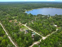
Land Maps & Attachments
Directions to Land
Detailed Directions to Property:
From Phoenix, Arizona (approximately 230 miles, 3.5-4 hours)
Begin your journey from Arizona's vibrant capital city into the serene high desert of Apache County:
Start: From downtown Phoenix, head east on I-10 East
Take I-10 East for approximately 35 miles
Merge onto US-60 East via Exit 154 toward Globe/Show Low
Continue on US-60 East for approximately 125 miles, passing through the historic copper mining towns of Globe and Miami
Continue through Show Low on US-60 East for approximately 45 miles
Pass through Pinetop-Lakeside continuing on US-60 East
Continue on US-60 East to Springerville/Eagar (approximately 70 miles from Show Low)
In Springerville, continue east on US-60 East/US-180 East for approximately 5 miles
Turn left (north) onto US-180 North toward St. Johns
Follow US-180 North for approximately 20 miles
Turn right toward Concho
Use your GPS device to navigate to coordinates 34.426000, -109.584700
The property is located in the Concho area accessible from local roads
Route Highlights: This spectacular scenic drive takes you from the low Sonoran Desert basin at approximately 1,000 feet elevation through the dramatic Mogollon Rim transition zone, climbing steadily to over 6,000 feet elevation in the high country. You'll pass through Globe and Miami, historic copper mining communities with fascinating territorial-era architecture and museums, traverse the world's largest continuous stand of ponderosa pine forests in the White Mountains region where elk, deer, and black bears roam freely, and eventually arrive in the sweeping grasslands and high desert country of Apache County where the landscape opens dramatically under impossibly blue skies. The journey itself showcases Arizona's remarkable geographic diversity, from saguaro cacti to pine forests to high desert plains.
From Flagstaff, Arizona (approximately 180 miles, 3 hours)
Journey from the mountain town of Flagstaff across the Painted Desert to your property:
Start: From downtown Flagstaff, head east on I-40 East
Take I-40 East for approximately 55 miles to Holbrook
Take Exit 286 for US-180 East toward St. Johns
Turn left onto US-180 East (Navajo Boulevard)
Follow US-180 East for approximately 95 miles through St. Johns
Continue on US-180 East past St. Johns for approximately 20 miles
Turn right toward Concho
Use your GPS device to navigate to coordinates 34.426000, -109.584700
The property is located in the Concho area
Route Highlights: This incredibly scenic drive takes you through the breathtaking Painted Desert region, where ancient geological formations display stunning bands of vibrant color ranging from deep reds to brilliant oranges, purples, and creamy whites created by mineral deposits in ancient lake beds. You'll pass through or near the Petrified Forest area with its 225-million-year-old fossilized trees scattered across badlands that look like something from another planet, cross expansive high plains where pronghorn antelope graze in herds of dozens, and traverse the dramatic transition from volcanic terrain near Flagstaff to ancient seabeds to rolling grasslands. St. Johns, the Apache County seat founded in 1879, offers a glimpse into Arizona's Mormon pioneer heritage with beautiful historic buildings. The landscape offers constantly changing vistas showcasing Arizona's remarkable geological history spanning hundreds of millions of years.
From Las Vegas, Nevada (approximately 450 miles, 6.5-7 hours)
Travel from the entertainment capital through the Arizona Strip to the high desert:
Start: From Las Vegas, take I-15 South
Follow I-15 South for approximately 125 miles to Exit 16 (UT-9 East/Hurricane/Zion National Park)
Take Exit 16 and turn left onto UT-9 East
Follow UT-9 East for approximately 25 miles through Hurricane, Utah
Continue on UT-9 East as it becomes AZ-389 East (entering Arizona)
Follow AZ-389 East for approximately 40 miles to Fredonia
Continue on AZ-389 East through Fredonia for approximately 30 miles
Turn right (south) onto US-89A South near Marble Canyon
Follow US-89A South for approximately 120 miles, crossing the spectacular Navajo Bridge over the Colorado River at Marble Canyon
Continue on US-89A South through House Rock Valley, climbing to the Kaibab Plateau
Continue on US-89A South through Jacob Lake and descending into the valley
Arrive in Bitter Springs and continue on US-89A South
Turn left (east) onto US-160 East near Tuba City
Follow US-160 East for approximately 80 miles through Navajo Nation lands
Turn right (south) onto US-191 South
Follow US-191 South for approximately 25 miles
Turn left (east) onto US-180 East toward St. Johns/Springerville
Follow US-180 East for approximately 15 miles
Turn right toward Concho
Use your GPS device to navigate to coordinates 34.426000, -109.584700
Route Highlights: This is arguably the most scenic route available, taking you through some of North America's most breathtaking and iconic landscapes. You'll enjoy spectacular views of the magnificent Vermilion Cliffs National Monument with 3,000-foot tall red sandstone cliffs, cross the mighty Colorado River at historic Marble Canyon where the river has carved through solid rock for millions of years creating a gorge over 800 feet deep with distant views toward the Grand Canyon, traverse the heavily forested Kaibab Plateau at over 8,000 feet elevation where mule deer and wild turkeys are commonly seen, and pass through sacred Navajo Nation lands with distant views of iconic monuments, mesas, and buttes that have stood for millions of years. This route showcases the incredible diversity and grandeur of the Colorado Plateau region, taking you through landscapes that have inspired artists, photographers, and filmmakers for generations.
More Land Details
More Land from David Healy
 0.2 AC : $15K
- 0.4 AC : $15K
- 3 AC : $19K
- 0.2 AC : $7.5K
- 0.6 AC : $38K
- 0.5 AC : $30K
- 0.2 AC : $16K
- New0.4 AC : $20K
- 0.2 AC : $10K
- 0.2 AC : $9K
- 0.2 AC : $10K
- 0.2 AC : $16K