Beautiful Dream Lakefront Property
Cedarcreek, MO 65627
Taney County, Missouri
Land Description
Owner Finance. No Credit check. I just now reduced the price of this property to sell it fast. It will not last long. Please also be advised this property is first come first serve. Thank you.
Size: 3.446 acres
Price: is with a minimum down payment. Owner Finance, no credit check. Please keep in mind the thumbnail says down, but currently this property is available for a minimum down, I'm trying to request that thumbnail be changed. Thank you.
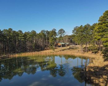
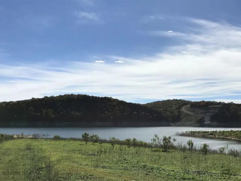
Stunning property with nice timber (both hardwoods and cedars) and about 172 feet of Direct frontage on the Corp Of Engineers “Take Line” at Bull Shoals Lake. A large 3.446 acre tract at the very popular Bull Shoals Lake about 30 miles from Branson, Missouri.
With about 172 feet of frontage on the “Take Line” at Bull Shoals Lake, you can walk directly from your property through the Corp Of Engineers land right to the water. Fish from the shore and fry up your catch on your own campfire. We have been told that you can also hunt in the Corp Of Engineers land which gives you hundreds of acres of additional hunting land adjacent to your property (in addition to the miles of accessible shoreline).
This 3.446 acre tract is located within an exclusive area called “Timber Shoals Ranch” on Bull Shoals Lake. This tract is a sportsman's dream sitting on a private peninsula on Bull Shoals Lake.
This special tract happens to be located at the southeast side of the private peninsula at Timber Shoals Ranch, in a private section called “Walleye Shores at Timber Shoals Ranch”. The tracts at “Walleye Shores” offer very easy access to the shoreline because the property slopes so gently to the water through the Corp Land.
The map above shows “Walleye Shores at Timber Shoals Ranch” which is a secluded area of only 14 tracts at the southeast side of Timber Shoals Ranch. The tracts at Walleye Shores offer maximum privacy as well as gentle access to the shoreline of Bull Shoals Lake.
We have found at least two natural access points to the water at Timber Shoals Ranch where we have put a boat into the water (there may be more access points that have not yet been discovered). State Line Cove (about a mile north of the property) is one access point where we have launched a pontoon boat and there is another access point at the very south end of the peninsula at the “Sandy Beach Area”, where we have also launched a pontoon boat and jet-skis.
This stunning property provides outstanding whitetail deer hunting, turkey hunting and world class fishing. This tract may be suited to an upscale homesite, a private and secluded cabin or just a place to come to camp and hunt for a few weeks out of the year.
This tract (all of the tracts at Timber Shoals Ranch) has Property Covenants in place to protect your investment. You can see them in detail farther down in this listing. Properties with access to a major lake have for years been one of the best choices for investment as well as enjoyment. This property has lots of mature timber and usable level areas. Great potential with this tract.
The full sales price for this 3.446 acre tract at Bull Shoals Lake is With your minimum down payment of you will automatically get the reduced interest rate of 5 3/4% and the monthly payments will be These payments are all based on about a 10 to 15 year payment schedule. Property taxes & maintenance fees will only be about a year and this is already included in the monthly payment amounts. There are NO prepayment penalties and NO hidden fees.
ALSO, if you decide to pay off your property (your loan) at any time within the next 5 years you will get a 5% Discount off of the remaining balance of the property.
Also, please be advised that I am personally in NO WAY affiliated with. I purchased this property from and am now trying to sell it because I have purchased another property from them and need to sell this one. The only way to relieve the payments is either to sell it or give it up, I cannot trade the property and I've put too much money into it to give it up, so I am trying to sell it. For convenience I use the link through so you can see all the details of the property including property covenants, and so you are very aware this is an property that I am simply trying to resell as another property they sold to me came available and I am currently remodeling and working on that property. Again, although I use the link for convenience and so you know what the property is all about, I am however IN NO WAY affiliated with nor do I represent. The link on may say the property is sold, but please be advised, so long as the property is still listed here on Landflip, it is Still For Sale...It was sold to ME, and that is why it says that, and I am now trying to resell the property.
I am also adding a provision in the contract to make this for all practical purposes a “rent-to-own” property so if you decide you do want to walk away from the property you are welcome to do so. I do this solely and only because I don't really like the “loan process” although I do loans myself, I feel like it is something to avoid when possible. There is also a very generous provision I put in there that if you have invested a lot of money into this but decide you want to walk away or run into financial difficulties, you do not lose the equity you put in the land. You can retain all the equity you have in the house minus and in addition any cleanup, advertising to resell the property, or any other extra fees that may be associated with the resell or cleanup of the property. In other words, if for some reason I incur unforeseen cost in the resell of the property whether caused from your leaving or resell of property etc, that will also be deducted from the equity. But for example, if you build a driveway and put in a nice cabin, but then for whatever reason you need to back out of the deal, you can keep the equity in your cabin, etc, minus the above fees listed. I'm doing that because all I care about is getting the money out of it I've put into it. It is a great investment that goes up in value.
The map above shows the entire peninsula of Timber Shoals Ranch. “Walleye Shores” would be the southeast side of the peninsula, where you will find this property. The 3.446 acres is outlined in red in the photo. The “brownish” shaded area is the Corp Of Engineers land around Bull Shoals Lake. The yellow lines are the easement roads/trails within Timber Shoals Ranch. The private peninsula has over 5 miles of shoreline, of which we have explored very little. The south side of the peninsula is where we found the “Sandy Beach Area”. The land slopes gently into the water by this sandy beach and it is an awesome place to spend the day. The pink line on the map above is a trail to State Line Cove on Bull Shoals Lake which is another place we have launched boats/jet skis.
On this private tract you will find large level areas as well as mature timber.
We have several videos of this breath-taking property; drone videos, ground videos, etc.
Power and phone are at the north end of Timber Shoals Ranch so they are within about a mile of the property. Utility easements are in place for the power/phone to be run to the property if/when you need them. Water would be by drilled well and sewer would be by septic tank or holding tank. We generally have fairly good cell service at Timber Shoals Ranch and the wifi in our truck generally works as well.
The property Directly borders the “Take Line” at Bull Shoals Lake along its north and east side. This area is renowned for its bass fishing, so much so that the B.A.S.S. Elite Series tournament was held right here in 2016. Huge walleye, catfish and many other types of fish can also be found in Bull Shoals Lake. You can fish this lake year around giving you unlimited fishing opportunities.
The photo above shows one area at the south end of the peninsula where you can potentially put your boat right into the water. When the water level is low you can enjoy a huge amount of very rare, sandy shoreline. Even when the water level is high you can fish right from the bank and possibly launch your boat or a jet ski. Both the sandy beach area and the trail to State Line Cove are very primitive boat launches (basically the ground just slopes gently into the water). There are probably concrete boat launches in the general area as well, but we have not tried to locate any of them.
Although the property is private and secluded you can get to Branson, Missouri in about 45 minutes. Springfield, Missouri (where our office is located) is a little over an hour to the north.
The aerial photo above shows how the property is situated. Bull Shoals Lake is a “Corp of Engineers” lake which means it was created and is maintained by the Army Corp of Engineers. On all “Corp of Engineers” lakes, the water itself as well as a buffer area around the water is actually owned/controlled by the Corp of Engineers. As a property owner with frontage on the Corp Of Engineers Line, you are able to use this additional land for hunting and recreation as well as to cross over in order to access the water. As no private individuals own the actual water on Bull Shoals Lake, a property that has frontage on the Corp Of Engineer's “Take Line” in generally considered lakefront. On the map above, the red area (outlined) is the property and the shaded area (brown) is the Corp of Engineers land which is what gives you the access to the water. From the east side of this property you can walk a very short distance to get right to the lake and enjoy a huge amount of shoreline.
Because the Corp Of Engineers Land is also generally open for hunting, you actually have direct access to several hundred acres of additional hunting land which directly adjoin your property.
In the photo above we are at a small cove near the property. You can see a large fish in the water - this area of Bull Shoals is renowned for its amazing fishing.
Timber Shoals Ranch has a proven “track record” for numerous deer and turkey. Almost every time we visit the area we see multiple deer and often we see turkey as well.
Please refer to our interactive map above for additional property views and information. The yellow lines on the map are part of the gravel easement road system running throughout Timber Shoals Ranch. These are minimum maintenance roads that are designed with a truck or an suv in mind (four wheel drive is also recommended). They will never be “highways”, which adds to the character of this secluded area. The property itself is outlined in red. Please note that the boundary lines and measurements on the interactive map are approximate. The property borders the easement road along its entire west side and it has about 172 feet of direct frontage on the “Take Line” along its east side.
To truly appreciate this property you may want to plan a visit to the area to check the property out and spend some time exploring. We can email you the direct link for the interactive map above so that you can view the map While you are looking at the property. All you need to do is download the MapRight app to your smartphone or tablet (free app) and then we can email the link to your phone. The interactive map is a Must when viewing the property as the easement road system is extensive and can be very confusing.
As these properties are high-quality investment grade tracts, they have similar Deed Assurances to some other upscale developments. As Timber Shoals Ranch is designed as an upscale lakeside community, these simple Deed Assurances have been designed to be minimally restrictive while still keeping your property value high.
Please see the link also to All of the property covenants for the property. The Deed Assurances include but are not limited to:
No mobile homes or modular homes are allowed
No portable buildings are allowed
No commercial activity is allowed
Camping is allowed for a maximum of 45 days in a 12 month period.
Residences must be on a minimum 600 square foot concrete foundation and up to two residences are allowed on each tract.
For building/camping purposes, there is a 100 foot setback from roadways and a 10 foot setback from side boundaries.
Please click on the land website link below to see all of the property covenants.
Also, please note that trees with a stump diameter of more than 8 inches may not be cut, sold or disturbed until the property has been paid for in full. You can however pretty easily get permission to take down trees to make improvements on the land such as to build a driveway or build a cabin in a particular spot.
We have been told that you can build you own home or cabin without permits or inspections from the county (must be 600 square foot minimum foundation size). Spend a few weeks this summer and build a vacation home/cabin with your friends or family.
The aerial photo above was taken over the south end of the peninsula at what we call the “Sandy Beach Area”. The truck is parked in the sand right by the water. To get to this area you take the main easement road all the way to the south end if the peninsula. There are possibly other areas with sandy shoreline as well, but we have not checked out all of the water frontage on the huge peninsula.
This is an amazing opportunity to own and use a high quality piece of real estate while watching the value rise. Generally, land with direct frontage on the “Take Line” is known to be a much safer and more profitable investment than land without “Take Line” frontage. Build your home or cabin and go fishing for your lunch and dinner.
Although the Corp Of Engineers is not currently issuing any new dock permits in the area, there are docks available for rent in the general area. It could be very convenient to store your boat right on your property and just put it into the water when you want to spend the day on the lake.
Fishing, jet skis, water skiing and tubing are all excellent here. Swimming at the sandy beach would be a fantastic way to create memories with family and friends.
The property is located in northern Arkansas, about a mile south of the Missouri/Arkansas state line. Although you will probably have all the wildlife you need on your private acreage (as well as the Corp Of Engineers Land), you are also just a short distance from about 50,000 acres of National Forest which is available for additional hunting and recreation.
Amazing centralized location. This tract is within half-a-day's drive to numerous large cities including St. Louis, Memphis, Little Rock, Tulsa and Kansas City. Yet it is totally private.
We have included multiple maps, pictures and videos that show this amazing tract of land. There is a lot to see so please take your time and check it all out.
Many of the roads/trails at Timber Shoals Ranch have not been used for years and we are in the process of cleaning them up to make them more usable. Our guys are in the process of cleaning them up but the roads were designed for trucks or SUVs and will always be rustic. We feel that the private easement roads add to the “private and secluded” feeling that you will enjoy while you are on your property. As Timber Shoals Ranch encompasses an entire peninsula it is a very safe and secure environment and access is Only for property owners and their guests. While the Corp Of Engineers land is open to the public, there are NO public roads leading to the Corp Of Engineers land on the peninsula (only the private roads within Timber Shoals Ranch).
Please also be advised the property link might say "property sold", but the property has NOT been sold. It was sold to me and I am reselling the property. So long as the property is still listed on Landflip and other ad platforms, the property is still for sale. Please inquire if you are unsure. Thank you.