Enjoy The Large Arizona Skies
Sanders, AZ 86512
Apache County, Arizona
Land Description
Price drop. Get out of town.....but not too far. Two corner lots with adjacent open space, good access, nearby services and utilities.
Discover Sanders, Az
Sanders, Arizona is a small Navajo Nation community in Apache County, located at the junction of I-40 and Us-191. With a population of about 575, it sits at 5,866 ft elevation near Chambers, Holbrook, and Gallup.
It's known for its Route 66 history, including the 1923 Sanders Bridge and long-running Burnham's Trading Post. The town has deep Navajo cultural roots, shaped by relocation during the Navajo-Hopi land dispute. The landscape features juniper, piñon pine, and views of the Defiance Plateau.
Today, Sanders is a quiet stop offering a mix of cultural heritage, historic roadside Americana, and proximity to northern Arizona's scenic high desert.
Owner Financing Available:
$200 down, $150/Month for 32 months
Cash Price: $5,000/Lot.
$249 documentation fee
Property Details:
Approximate Address: 294 Dine'h Tah Blvd, Sanders, AZ 86512
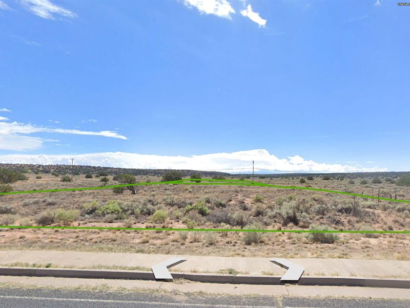
Size: Lot 322 1.05 acres, Lot 323 1.1 acres
APN: 207-26-322 and 207-26-323
Legal Description: Lot 322 and/or Lot 323, Arizona Park Estates Unit One
GPS Coordinates: 35.197, -109.323
Elevation: 5,850 feet
Annual Taxes: $6.06 and $6.36
Terrain: Flat desert with brush
Zoning: Agriculture General (Ag) with residential allowances
Build Options: Single family and mobile homes 400 square feet.
Camping & RV: Allowed for extended periods
Access & Location Benefits:
Only ½ mile from US Highway 191 and the Valley High School. The Sanders Rodeo Arena is even closer.
Road Access: Dine'h Tah Blvd, paved access
Closest Town: Sanders, AZ is less than 2 miles
Major Highway: Us-191 and I-40 intersection nearby
Gas Station: Speedway less than 5 minutes
Petrified Forest National Park is only 28 miles. The Painted Desert Inn, Tiponi Point, and other attractions are all within 40 minutes.
Utilities & Development: Power is adjacent to Lot 323 on the south side. Well and septic required (standard for rural investment property)
Apache County
“Possessing a unique and distinct beauty, ours is a county of contrasts. From the blue spruce and aspen-covered mountains near Alpine and Nutrioso to Greer Valley where the clear, cold waters of the Little Colorado River flow northward to Round Valley and St. Johns, and truly a world apart, the Navajo Nation lands with their piñon-covered mesas, red sandstone cliffs, huge open valleys, and hidden canyons, the splendor of Apache County abounds.”
Directions to Land
US Highway 191 south from Interstate 40 at Sanders, Arizona. Turn east on Dine'h Tah Blvd and drive 1/2 mile. Properties are on the south side of the road.


