Creek Side Mountain Homestead CO
Fort Garland, CO 81133
Costilla County, Colorado
Land Description
Land Description
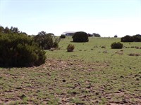
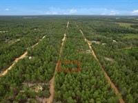
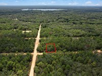
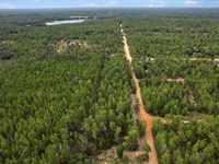
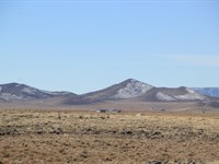
Welcome to 5.139 acres of pristine mountain paradise in the beautiful Sangre de Cristo Ranches near Fort Garland, Colorado. This exceptional creek-side property is perfect for building your dream mountain homestead or creating a peaceful recreational retreat. With seasonal creek frontage, mature tree coverage, stunning 360-Degree mountain views, and varied terrain ideal for off-grid living, you'll have endless opportunities to create the self-sufficient lifestyle you've been dreaming about.
Located just 10 miles from the historic town of Fort Garland, you'll have easy access to essential amenities while enjoying complete privacy and solitude. Mountain Home Reservoir sits just 20 miles away, offering world-class fishing and water recreation. The legendary Great Sand Dunes National Park is only 36 miles north, providing unique adventures year-round.
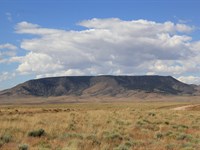
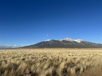
However, the real selling points of this property are the natural creek that flows through the land and the breathtaking panoramic views of the Sangre de Cristo Mountain Range. The property is situated at approximately 7,900 feet elevation in a prime location, giving you stunning vistas of snow-capped peaks, including Mount Blanca, Colorado's fourth-highest fourteener at 14,345 feet.
As a bonus, the property features multiple-level building sites perfect for your mountain home, excellent solar exposure with over 280 days of annual sunshine, and varied terrain offering natural zones for gardens, pasture, and wildlife habitat. The seasonal creek provides precious water for permaculture systems, livestock, and creates a beautiful natural feature rarely found at this price point.
Don't miss out on this incredible opportunity to own creek-side mountain acreage in one of Colorado's most beautiful and affordable regions. Properties with water features don't last long.
We are open to owner financing as well - contact us for details.
See Info below:
- Subdivision: Sangre de Cristo Ranches
- State: Colorado
- County: Costilla
- Zip: 81133
- Size: 5.139 acres
- Parcel: 70240980
- Legal Description: S.D.C.R. Unit J-3 BLK 333 Lot 7406 (Jwd 250-660) Cont 5.139 Ac
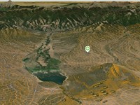
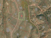
- Approximate Lat/Long Coordinates: 37.4575, -105.3129
- Annual Taxes: Approximately $284.60/Year
- Zoning: Estate Residential (Er)
--- For a site-built home, you need a 600 sq ft minimum footprint
--- Mobile homes are allowed
--- You can camp for 14 days (every 3 months)
--- Temporary RV Occupancy permit available for up to 180 days if a well has been permitted or a cistern installed and a septic or onsite waste management system has been installed ($250 fee - good for 60 days at a time while building, renewable)
--- Zoning office is open Monday through Thursday and can be contacted to answer any questions
- Hoa/Poa: No. Minor protective covenants, but no HOA to enforce them
- Improvements: Seasonal creek, mixed terrain with trees and meadow
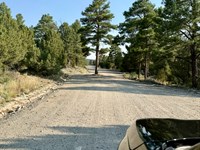
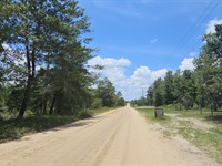
- Access: Year-round county maintained road
- Water: Seasonal creek on property, well or cistern required for potable water
- Sewer: Would be by septic or alternative system
- Utilities: Electric available at or near property line; Alternative Energy (Solar, wind, or generator) highly recommended; Phone would be cellular or Satellite; Tv/Internet would be Satellite (Starlink highly recommended)
Information presented in this listing is deemed accurate but is not guaranteed. Buyers are advised to conduct their own due diligence and verify all details independently.
---
Location And Setting Overview
- Your Mountain Homestead Sanctuary in Colorado's Hidden Gem: This remarkable 5.139-Acre property sits in the heart of Sangre de Cristo Ranches, positioned perfectly on the eastern edge of the legendary San Luis Valley where the valley floor meets the dramatic Sangre de Cristo Mountain Range. At 7,900 feet elevation, your land occupies one of Colorado's most spectacular settings - where the high desert grasslands transition into the foothills of some of the state's most impressive peaks. This is your opportunity to own affordable Colorado mountain land with a rare water feature that sets it apart from typical dry parcels in the region.
- Creek-Side Living - The Homesteader's Dream: The seasonal creek flowing through this property represents its most valuable feature and biggest differentiator. In Colorado's high desert climate where water is precious, having natural water on your land transforms your homesteading potential. The creek creates riparian habitat with lush vegetation, provides water for livestock and gardens, supports permaculture and swale systems, attracts abundant wildlife, and offers the peaceful sound of flowing water during spring runoff and summer monsoons. This creek makes possible sustainable practices that would be challenging on dry land - from intensive vegetable gardens to small-scale livestock operations. Properties with water features at this price point are increasingly rare in Colorado as buyers recognize their unique value.
- Geographic Position and Mountain Access: Your property coordinates place you approximately 10 miles south of Fort Garland along the eastern valley corridor, with direct views toward the towering Sangre de Cristo Range that rises over 6,000 feet above the valley floor. This positioning gives you the best of both worlds - the open vistas and sunshine of the San Luis Valley combined with immediate proximity to mountain wilderness. The Sangre de Cristo Mountains, whose Spanish name means "Blood of Christ" for their crimson alpenglow at sunrise and sunset, form your eastern horizon with peaks like Mount Blanca at 14,345 feet, Culebra Peak at 14,047 feet, and the Trinchera massif creating an ever-changing backdrop of shadows, light, and seasonal snow. Every morning brings a new mountain masterpiece painted across your eastern skyline.
- The Sangre de Cristo Ranches Community: You're not just buying land - you're joining a vibrant community of homesteaders, off-grid enthusiasts, artists, ranchers, and mountain lovers who've chosen this spectacular location for their own retreats. Sangre de Cristo Ranches was originally part of the historic Forbes Trinchera Ranch, one of Colorado's legendary working ranches. The subdivision preserves the ranching character while providing families with individual homesites in this spectacular mountain setting. Unlike typical subdivisions, the original developers set aside over 5,000 acres of common greenbelt land for recreational use by property owners, giving you access to vastly more territory than just your private 5 acres. This shared recreation area provides exclusive hunting, hiking, and exploration opportunities available only to landowners.
- Fort Garland - Your Gateway Town: Just 10 miles north lies the historic community of Fort Garland, your closest hub for essential services and fascinating frontier history. Fort Garland was established in 1858 as a U.S. Army outpost to protect settlers and maintain peace with the Ute Indians. The fort's most famous commander was legendary frontiersman Kit Carson, who served here from 1866 to 1867. Today, the beautifully preserved fort operates as a museum where you can explore original adobe barracks, officers' quarters, and exhibits featuring the Buffalo Soldiers who served here. Beyond history, Fort Garland provides practical amenities including Old Fort Market grocery store, gas stations, post office, and several restaurants serving hearty breakfasts and classic southwestern cuisine. Highway 160 passes through Fort Garland, making it your gateway to larger towns and mountain recreation.
- Alamosa - Your Regional Shopping Hub: For major shopping and services, Alamosa sits approximately 35 miles northwest and serves as the San Luis Valley's commercial center with a population around 9,000. Alamosa offers everything homesteaders need for modern living while maintaining small-town friendliness. The city features major retailers including Walmart Supercenter, Home Depot, Safeway, and City Market for comprehensive shopping. Tractor Supply Company and local farm stores provide livestock feed, fencing materials, and homesteading supplies. San Luis Valley Regional Medical Center provides full hospital services with emergency room, surgical facilities, and specialty clinics. When you need building supplies, well drilling equipment, livestock feed, or specialized tools, Alamosa delivers without the crowds and expense of larger cities. Most homesteaders make monthly supply runs to stock up while enjoying the convenience of staying close to their land the rest of the time.
- Mountain Home Reservoir Recreation: One of your property's greatest advantages is proximity to Mountain Home Reservoir, approximately 20 miles northeast in the Sangre de Cristo foothills. This spectacular mountain reservoir holds 19,500 acre-feet of crystal-clear water at over 9,000 feet elevation and ranks as one of southern Colorado's premier fishing destinations. The reservoir is regularly stocked with rainbow trout and brown trout, with many anglers consistently catching fish in the 14 to 20-inch range. Trophy trout over 24 inches are landed here every season. The reservoir features boat launches allowing you to explore the entire shoreline, and primitive camping sites let you spend weekends fishing from dawn to dusk. Whether you prefer trolling from a boat, casting from shore, or fly fishing the inlet streams, Mountain Home Reservoir delivers world-class mountain angling just minutes from your homestead.
- Climate Perfection for Off-Grid Living: Your elevation delivers ideal mountain climate without the extremes of higher altitudes. At 7,900 feet, you experience four distinct seasons with approximately 280 days of sunshine annually - more sunny days than San Diego, California. This exceptional solar resource makes your property among the best in the nation for off-grid solar power systems. Summer days typically reach comfortable mid-70s to low 80s with cool evenings dropping into the 40s, perfect for sleeping without air conditioning. Winter brings manageable snowfall and daytime highs often in the 30s with brilliant sunshine that quickly melts snow from south-facing slopes. The high desert climate means low humidity year-round, making hot days comfortable and cold days more tolerable than humid climates. Your growing season runs approximately 90-110 frost-free days, perfect for cold-hardy vegetables, berries, and perennial crops that thrive in Zone 4-5 conditions.
- Remote But Not Isolated - The Perfect Balance: One of this property's biggest advantages for homesteaders is its balanced location. You're far enough from town to enjoy complete privacy, dark night skies perfect for stargazing, and the peace you've been craving. Yet you're close enough to civilization that supply runs take less than an hour, emergency services can reach you, and you're not completely cut off during winter weather. This balance proves crucial for successful homesteading - you maintain self-sufficiency while having the security of accessible services when needed. Many failed homesteads suffer from being too remote, where every supply trip becomes an expedition and emergencies become crises. Your property avoids this trap while still delivering the mountain retreat experience you desire.
Homesteading And Off-Grid Living Potential
- Your Path to Self-Sufficient Living: This property provides exceptional opportunities for modern homesteading and off-grid living, allowing you to break free from monthly utility bills and achieve true energy independence. The combination of seasonal creek water, 280+ days of annual sunshine, varied terrain offering natural zones for different activities, and 5.139 acres of manageable space creates the perfect foundation for sustainable living. Whether you're planning complete off-grid independence or a hybrid approach with some grid connections, this land supports your vision.
- Solar Power Paradise: With over 280 days of sunshine annually and high-altitude location that increases solar panel efficiency, your property sits in one of Colorado's absolute best solar energy zones. The San Luis Valley receives more solar radiation than almost anywhere in the continental United States, making solar power exceptionally productive and reliable. A properly sized solar array can generate all the electricity needed for a comfortable modern home including lights, appliances, electronics, water pumping, power tools, and even electric vehicle charging. Most off-grid solar systems consist of photovoltaic panels mounted on roof racks or ground arrays, a charge controller regulating power flow to batteries, a battery bank storing energy for nighttime and cloudy periods, and an inverter converting DC battery power to standard AC household current. Modern lithium batteries have revolutionized off-grid solar by providing more storage capacity, longer lifespans, and better cold-weather performance compared to older lead-acid batteries. A typical 3 to 5-kilowatt solar system with adequate battery storage can power a modest efficient home year-round. The beauty of solar power is its scalability - start with a smaller system and expand as needs or budget allow.
- Water Systems for Homesteading Success: Water management forms the foundation of successful homesteading, and this property offers multiple excellent options. The seasonal creek flowing through your land provides surface water during spring runoff and summer monsoon seasons - perfect for irrigating gardens, watering livestock, and supporting permaculture systems. For year-round potable water, drilling a domestic well represents the most permanent solution. Well depths in the Sangre de Cristo Ranches area typically range from 150 to 300 feet depending on location and geology, with drilling costs averaging $30 to $40 per foot. Wells produce water on demand and provide unlimited supply for household use, gardens, and animals. Alternatively, many property owners start with cistern systems - large water storage tanks that you fill by hauling water from town or hiring water delivery services. A 1,500 to 2,500-Gallon cistern provides adequate storage for a small household using water conservatively, with refills needed every few weeks to months. Cisterns cost significantly less than drilling wells and work perfectly during the building phase. You can always start with a cistern and drill a well later when budget allows. The combination of creek water for irrigation and well/cistern for drinking creates a robust water system supporting serious homesteading.
- Growing Food - Gardens and Orchards: Your 5.139 acres provides excellent space for productive gardens and small orchards. The creek-side areas offer natural moisture and rich soil perfect for intensive vegetable gardens. Open meadow sections can be developed into larger garden plots with drip irrigation from your well. At 7,900 feet elevation (Zone 4-5), you can successfully grow cold-hardy vegetables including potatoes, carrots, beets, turnips, lettuce, spinach, kale, Swiss chard, peas, and many bean varieties. Root crops excel in this climate with its cool nights. Short-season tomatoes, peppers, and squash succeed with protection and careful variety selection. Cold frames and simple hoop houses extend the growing season by weeks on both ends, enabling spring planting in April and fall harvests into October. Many San Luis Valley homesteaders successfully grow amazing gardens despite the short season by working with the climate rather than against it. For fruit production, hardy apple varieties like Liberty and Zestar thrive here, along with pie cherries, plums, and extensive berry plantings. Strawberries, raspberries, currants, and gooseberries produce abundantly once established, providing fresh fruit for eating and preserving. The key is choosing cold-hardy varieties and providing some wind protection.
- Livestock and Small-Scale Ranching: Your 5.139 acres can support small-scale livestock operations perfect for family food production. With proper fencing and shelter, you can raise chickens for eggs and meat (as many as you want - chickens require minimal space), 4-6 dairy or meat goats, 6-8 sheep, a few pigs, rabbits in hutches, and even a family milk cow if you manage pasture carefully with rotational grazing. The seasonal creek provides natural water for animals during flow periods, supplemented by well or cistern water year-round. The varied terrain offers both open areas for daytime grazing and wooded sections providing shade and wind protection. Livestock adds tremendous value to homesteads by converting pasture and garden waste into eggs, milk, meat, and valuable fertilizer. The learning curve is manageable - start with hardy chickens, add goats or sheep once you've gained confidence, and expand from there. Many property owners in Sangre de Cristo Ranches have received permission to keep reasonable numbers of livestock appropriate to their acreage - something you can explore once you own the property.
- Permaculture and Regenerative Systems: This property's natural features make it ideal for permaculture design principles. The seasonal creek allows creation of swales and water harvesting systems that capture and store moisture. The varied elevations and aspects provide different microclimates you can optimize for specific plants. Natural windbreaks from existing trees can be expanded with additional plantings. The mix of sun and shade areas lets you create productive forest gardens under tree canopies while maintaining sunny garden beds for annual vegetables. Composting systems can recycle all organic waste from gardens, animals, and kitchen into valuable soil amendments. Over time, you can build soil fertility and water-holding capacity while establishing perennial food systems requiring minimal inputs. The goal of permaculture is working with nature's patterns to create abundant, self-sustaining systems - and this property's natural diversity provides the perfect canvas.
- Building Your Homestead - Structures and Infrastructure: The property offers multiple excellent building sites with level to gently rolling terrain, spectacular mountain views, and good solar exposure. Your main residence can be site-built from conventional materials, constructed as a beautiful log cabin, built as an efficient modern design, or even be a quality manufactured home meeting county requirements. The minimum footprint is just 600 square feet for a single-story dwelling, though most homesteaders build 800 to 1,500 square feet for comfortable family living. Beyond your home, you can construct detached garages for vehicles and equipment, storage sheds for tools and supplies, workshops for projects and food processing, greenhouses for season extension, chicken coops and livestock shelters, root cellars for food storage, and any other structures supporting your homestead. Many owner-builders construct their garage or workshop first, using it to store materials and tools while building their main home. This practical approach lets you live in an RV or camper (with proper permits) while completing construction. The county supports owner-builders and alternative construction methods, making your vision achievable.
- Off-Grid Energy Independence: Beyond solar power, your complete energy system might include supplemental wind generation (the valley's steady breezes can power small turbines), propane for cooking and backup heating (delivered regularly to your property by local suppliers), wood heat from sustainable timber management on your land or nearby common areas, and a backup generator for extended cloudy periods or high-demand situations. Most successful off-gridders design hybrid systems where renewable sources provide the majority of power while propane and generators handle specific tasks more efficiently than electricity. For example, propane excels for cooking, instant hot water, and space heating, while solar electricity powers lights, electronics, and appliances. This hybrid approach provides comfort and reliability while maintaining energy independence.
- Internet and Modern Connectivity: Modern homesteading doesn't mean disconnecting from the world. Starlink satellite internet provides high-speed broadband with download speeds exceeding 100 Mbps, enabling remote work, video streaming, online education, and all digital activities from your mountain homestead. This revolutionary service has transformed rural living by delivering urban-quality internet anywhere with clear sky views. Combined with cellular coverage from major carriers reaching most of Sangre de Cristo Ranches, you maintain full connectivity while living off-grid. Many homesteaders now operate remote businesses, attend online meetings, and stay connected with distant family while enjoying mountain living - the best of both worlds.
- Gradual Development Strategy: The beauty of homesteading is that you can develop at your own pace. Many owners follow a logical progression: First, secure the property and begin regular visits to understand the land and plan your layout. Second, drill a well or install a cistern to establish water access. Third, install septic system and obtain county approval. Fourth, obtain building permits and possibly temporary RV occupancy permit. Fifth, begin construction while camping or staying in RV on-site. Sixth, install solar panels early to power tools and construction needs. Seventh, complete main residence and pass final inspections. Eighth, add outbuildings, gardens, and infrastructure over subsequent years. This gradual approach lets you spread costs over time while building equity with each improvement. Some homesteaders complete everything in one intense construction season, while others develop slowly over 3-5 years while maintaining city jobs. The timeline is yours to control based on your circumstances and goals.
Recreational Opportunities
- Your Gateway to Wilderness Adventure: Owning property in Sangre de Cristo Ranches means living at the doorstep of some of Colorado's most spectacular and least-crowded recreational opportunities. While Front Range residents fight traffic and crowds to reach the mountains, you wake up surrounded by them. Your property provides immediate access to millions of acres of public lands, world-class fishing, trophy hunting, challenging fourteener climbs, and winter sports that rival anywhere in the Rocky Mountains.
- Great Sand Dunes National Park Proximity: One of Colorado's most unique national parks sits approximately 36 miles north of your property. Great Sand Dunes National Park protects the tallest sand dunes in North America, with massive dunes rising 750 feet above the valley floor. The park offers extraordinary recreation including sandboarding down steep dune faces, sand sledding for families, hiking to the dune ridgelines for spectacular views, and wading in seasonal Medano Creek that flows at the dunes' base during spring runoff. The juxtaposition of massive sand dunes against snowy mountain peaks creates surreal landscapes found nowhere else. The park's dark skies make it exceptional for stargazing and astrophotography, with ranger-led astronomy programs during summer months. Your proximity means you can visit the dunes for morning photography, afternoon sand sliding, or evening stargazing without the long drive facing Front Range residents. This is truly one of nature's most remarkable places, and it's practically in your backyard.
- Mountain Home Reservoir Fishing Paradise: This stunning mountain reservoir ranks among southern Colorado's premier fishing destinations and sits just 20 miles from your property. At over 9,000 feet elevation, Mountain Home Reservoir's 19,500 acre-feet of cold, clean water provides ideal habitat for trophy trout. Colorado Parks and Wildlife regularly stocks the reservoir with rainbow trout and brown trout, maintaining excellent fish populations and consistent catch rates. Local anglers report regular catches of trout in the 14 to 20-inch range, with trophy fish over 24 inches landed throughout the season. The reservoir allows boats, and many serious anglers troll the deeper waters to reach the biggest fish. Shore fishing remains productive, especially near the dam and inlet areas where structure attracts feeding trout. The reservoir opens for ice fishing in winter when safe ice conditions develop, providing unique opportunities to catch trout through the ice while surrounded by snow-covered peaks. Primitive camping areas along the shore let you spend entire weekends focused on fishing without returning to town. For fishing enthusiasts, this nearby reservoir alone justifies property ownership.
- Fourteener Peak Access: The Sangre de Cristo Range rising directly east of your property contains some of Colorado's most impressive fourteeners. Mount Blanca at 14,345 feet stands as Colorado's fourth-highest peak and dominates your northeastern horizon. The standard route up Blanca starts from Como Lake trailhead, approximately 45 minutes from your property, and follows a challenging but non-technical path through pristine wilderness to the spectacular summit with views spanning three states. Culebra Peak at 14,047 feet represents Colorado's southernmost fourteener and offers a more exclusive climbing experience. For peak baggers and mountain lovers, living within an hour of these magnificent summits means you can climb them multiple times per season, watching their character change from snow-covered spring ascents to summer wildflower hikes to fall colors painting the slopes.
- Sangre de Cristo Wilderness Exploration: The Sangre de Cristo Wilderness encompasses 220,000 acres of designated wilderness where motorized vehicles are prohibited and nature reigns supreme. Your property sits within 20 minutes of multiple wilderness access points where maintained trails lead into pristine backcountry. The wilderness contains over 50 alpine lakes nestled in glacial cirques, perfect for backcountry fishing and photography. Miles of maintained trails accommodate all skill levels from gentle valley hikes to challenging scrambles above treeline. Backpackers can plan multi-day expeditions linking alpine lakes and peaks with camping in designated wilderness sites where ancient bristlecone pines thousands of years old cling to windswept ridges. Day hikers enjoy spectacular outings to waterfalls, meadows filled with summer wildflowers, and viewpoints offering panoramic vistas. The wilderness's position on the valley's eastern edge means you can hike from desert grasslands through multiple ecosystems to alpine tundra in a single day - an ecological journey normally requiring hundreds of miles of travel.
- Hunting in Game Management Unit 83: Your property location within Game Management Unit 83 provides access to some of Colorado's finest big game hunting. The unit's reputation for quality elk hunting draws hunters from across the country, with the Trinchera elk herd numbering over 15,000 animals. During September's archery season, bulls bugle across the valley in one of nature's most spectacular displays. Rifle seasons in October and November provide opportunities to harvest trophy bulls, with GMU 83 consistently producing success rates above state averages. Mule deer populations remain strong, with mature bucks inhabiting the foothills and draws near your property. The Sangre de Cristo Ranches' 5,000-Acre common greenbelt provides exclusive hunting access for property owners, offering distinct advantages including lower hunting pressure compared to public lands. Many property owners utilize their land as base camps during hunting season, setting up wall tents or parking RVs to maximize time afield while enjoying the comfort of their own property.
- OHV and Mountain Biking: Thousands of miles of forest service roads, BLM routes, and designated OHV trails let you explore remote areas inaccessible to standard vehicles. Popular OHV destinations include trails climbing into the Sangre de Cristo foothills with views back across the valley, routes following historic mining roads to abandoned camps, and challenging technical trails. Mountain bikers can ride everything from smooth valley roads to challenging singletrack descending mountain slopes. The combination of high elevation, dramatic scenery, and endless routes makes this region a paradise for two-wheeled adventurers.
- Winter Recreation: Wolf Creek Ski Area, Colorado's legendary powder destination receiving over 430 inches of natural snowfall annually, sits approximately two hours west. The resort features 1,600 acres of skiable terrain with a laid-back, uncrowded atmosphere compared to I-70 mega-resorts. Closer to home, the Sangre de Cristo Range offers unlimited backcountry skiing and snowshoeing opportunities for properly equipped winter travelers. Numerous drainages hold skiable snow from December through April, with some high bowls maintaining snow into June.
Wildlife And Natural Beauty
- Living Among Colorado's Wild Residents: Owning this property means sharing your environment with remarkable wildlife populations that have inhabited this landscape for millennia. Your 5.139 acres sits within critical wildlife habitat where multiple species migrate, feed, and raise young throughout the year. The transition zone between valley grasslands and mountain foothills creates especially rich habitat supporting incredible biodiversity.
- Rocky Mountain Elk Encounters: The legendary Trinchera elk herd passes through this area, representing one of Colorado's greatest wildlife treasures. This massive herd contains an estimated 15,000+ elk, making it one of the largest elk populations in North America. During spring and fall migrations, herds of 50 to 100+ animals move between high summer range and lower winter habitat. In September during the rut, bull elk produce their distinctive bugling calls that echo across valleys and meadows - one of nature's most spectacular audio experiences. Large bulls sporting massive six-point or larger antler racks create dramatic encounters. During early morning and late evening, elk frequently appear on or near properties in Sangre de Cristo Ranches, offering daily wildlife viewing opportunities that urban residents pay thousands to experience on guided trips.
- Mule Deer and Wildlife Viewing: Mule deer inhabit the foothills, draws, and brushy areas throughout the region. These impressive animals with their characteristic huge ears browse on native vegetation and can often be observed in groups. Mature mule deer bucks grow impressive antlers, and the November rut brings increased activity. Both deer and elk remain visible year-round, with winter concentrations bringing animals down from high elevations to more accessible areas. Pronghorn antelope - North America's fastest land mammal capable of sustained speeds over 55 miles per hour - inhabit nearby grasslands and occasionally cross through the area. Watching pronghorn race across open country provides an exhilarating wildlife encounter.
- Predators and Wild Character: Mountain lions roam throughout the Sangre de Cristo Range, maintaining territories that can span 100 square miles. These powerful predators primarily hunt deer and elk, playing a crucial role in maintaining healthy prey populations. Mountain lion sightings remain rare due to their secretive nature, but tracks and occasional observations remind property owners that true wilderness predators still inhabit these mountains. Black bears inhabit the forested slopes and canyons east of your property, spending summer and fall feeding on berries, acorns, and insects. Coyotes provide much more visible encounters, with their evening and morning howling sessions echoing across the valley. Bobcats inhabit brushy areas and rocky terrain, though their elusive nature makes sightings uncommon.
- Raptors and Bird Life: Golden eagles soar on seven-foot wingspans above the valley and foothills, hunting for rabbits and prairie dogs while performing spectacular aerial displays during courtship. Bald eagles winter along waterways, particularly the Rio Grande. Peregrine falcons nest on high cliff faces, making dramatic high-speed dives exceeding 200 miles per hour. Great horned owls inhabit wooded areas, their distinctive hooting calls breaking the evening silence. Red-tailed hawks circle overhead during daylight hours, searching for prey from their aerial perches. The San Luis Valley lies beneath major migratory flyways, creating exceptional bird watching throughout the year.
- Seasonal Creek Wildlife Habitat: Your property's seasonal creek creates especially rich habitat attracting wildlife year-round. The riparian zone along the creek provides water, cover, and food that draws deer, elk, and smaller mammals. Birds concentrate near water sources, making the creek area exceptional for wildlife observation. During spring and summer when the creek flows, you'll observe constant wildlife activity - deer coming to drink at dawn and dusk, elk cows bringing calves to water, songbirds bathing and nesting in creek-side vegetation, and hawks hunting from perches overlooking the water. This natural wildlife magnet makes your property especially valuable for nature lovers and provides endless opportunities for photography and observation.
- Dark Sky Stargazing: At 7,900 feet elevation with minimal light pollution, your property offers spectacular stargazing opportunities. The Milky Way stretches overhead in brilliant detail on moonless nights. Meteor showers provide spectacular displays without urban light interference. The San Luis Valley's high, dry atmosphere and clear skies make it one of the best stargazing locations in the Lower 48. Many property owners find the night sky alone worth the investment - reconnecting with the cosmos in ways impossible in light-polluted areas.
Building And Development Information
- Understanding Your Rights and Protections: Your 5.139-Acre property comes with carefully crafted protective covenants established when Sangre de Cristo Ranches was originally developed. These covenants preserve the rural, ranch-like character of the subdivision while giving property owners substantial freedom to build their dream mountain retreats. Unlike heavy-handed homeowner associations that micromanage every detail, these covenants simply establish common-sense guidelines ensuring all properties maintain appropriate quality and use.
- Residential Building Requirements: The covenants specify that land shall be used for residential purposes, with no more than one family per main dwelling. For your main residence, minimum building sizes ensure quality construction - a one-story home must provide at least 600 square feet of habitable floor space, while a two-story dwelling must contain at least 800 square feet. These measurements specifically exclude basements, porches, and garages, meaning your actual living area must meet these minimums. This ensures all homes maintain a certain standard while still allowing for cozy cabins and efficient designs perfect for off-grid living.
- Building Setbacks and Placement: Your main residence must be set back at least 30 feet from any boundary along a street or road, and at least 25 feet from other property boundaries. These setback requirements provide privacy between neighboring properties, create space for utilities and access, and maintain the open, uncrowded feeling that makes rural living appealing. Your 5.139 acres provides abundant options for siting your home to maximize views, sunshine, privacy, and access while easily meeting all setback requirements.
- Accessory Buildings and Outstructures: Beyond your main residence, the covenants permit appropriate ancillary buildings that complement your primary home. You can construct detached garages, storage sheds, barns (if livestock permitted), workshops, greenhouses, and other structures supporting your homesteading lifestyle. These accessory buildings have no minimum size requirements and must simply be kept in harmony with your main residence. Many property owners build their garage or workshop first, using it to store materials and tools while constructing their main home - a practical approach fully permitted under the covenants.
- Manufactured and Modular Home Options: The covenants do not prohibit manufactured homes, making them a viable and affordable option for establishing your mountain residence. Quality manufactured homes can be installed on proper foundations, meeting all building standards while costing significantly less than site-built construction. Modern manufactured homes feature quality construction, attractive designs, and efficient floor plans that work beautifully for mountain living.
- Livestock Considerations: The covenants have restrictions regarding livestock including horses, cattle, sheep, goats, pigs, and chickens. These animals may only be kept with prior written permission from the original declarant. This restriction preserves the residential nature while still allowing property owners with adequate space to receive permission for reasonable numbers of animals appropriate to their acreage. Many property owners have received permission to keep horses or chickens for personal use, particularly on larger parcels. If livestock is part of your homesteading vision, this is something you can explore and potentially obtain permission for once you own the property.
- RV and Camping During Development: While building your permanent residence, you can obtain temporary permits allowing you to stay in an RV or camper on your property. The county offers RV occupancy permits for up to 180 days annually, with provisions for renewal while construction progresses. Short-term camping of up to 14 days every three months requires no permit at all. These provisions let you live on your land while building, saving rental costs and allowing you to personally oversee construction - a huge advantage for owner-builders.
- Your Freedom to Build Your Vision: The combination of reasonable covenants and supportive county regulations gives you substantial freedom to create the mountain retreat you've always imagined. Whether you envision a cozy log cabin, an efficient modern home, or a quality manufactured home, you have the flexibility to make it reality. The covenants protect everyone's property values by maintaining basic standards while avoiding the petty restrictions common in urban HOAs. Your property, your vision, your freedom - within sensible guidelines that benefit everyone.
Investment Value And Opportunity
- Appreciation Potential in Colorado's Most Affordable Mountain Region: The San Luis Valley represents Colorado's last frontier of affordable mountain property, with land prices remaining a fraction of comparable mountain regions throughout the state. As Colorado's population continues growing and more people discover remote work opportunities, demand for rural properties with good internet access (hello, Starlink.) will only increase. Properties with water features like your seasonal creek are especially positioned for appreciation as buyers recognize their unique value. While no one can guarantee future appreciation, the fundamental economics of limited mountain land supply meeting growing demand suggest strong long-term value growth.
- Multiple Exit Strategies: Whether you plan to build and live here, use it as a recreational retreat, develop and sell, or hold for long-term appreciation, this property accommodates multiple strategies. You might build your dream homestead and live here forever. Or develop the property with infrastructure (well, septic, power, driveway) and sell for significant profit to someone wanting a turnkey building site. Or simply hold the raw land, paying minimal annual taxes while it appreciates. Or use it recreationally for years before building. The flexibility creates options based on your evolving circumstances and goals.
- Owner Financing Available: [Include your specific owner financing terms here if offering, following the format from the template with down payment, monthly payment, and term details]
- Take Action Today: Opportunities like this don't last forever. Properties with water features at this price point are increasingly rare as buyers recognize their unique value for homesteading and sustainable living. As more people discover the San Luis Valley and Sangre de Cristo Ranches, property prices will inevitably rise toward those of comparable mountain regions. The window of affordability continues narrowing as demand increases. Don't let this chance slip away while you delay and debate. Contact us today for complete information, answers to all your questions, and assistance securing this property before someone else recognizes the same opportunity you see.
- Begin Your Mountain Homestead Adventure: Imagine yourself on this land next year - perhaps tending your first garden watered by the creek, watching elk graze on the hillside at dawn, sitting on your porch watching sunset paint the Sangre de Cristo peaks crimson, or breaking ground on your energy-independent homestead. That vision becomes reality when you take the first step of securing ownership. This property awaits your arrival, ready to become your mountain sanctuary, your weekend escape, your homesteading dream, your off-grid paradise, or your family's legacy. The question isn't whether this property offers incredible value and opportunity - the question is whether you'll act decisively to claim it as your own.
We are open to owner financing as well - here is what that would look like:
Cash Price: $12,499
Easy Financing Option:
- Down Payment: $258
- Documentation Fee: $199
- Total Due Today: $457
- Monthly Payment: $258/Month for 72 months
- Loan Term: 6-Year Easy Financing Plan
- Total Monthly Payment: $258 x 72 months $18,576
With our easy financing option, you can own this beautiful creek-side mountain property for less than most people spend on a car payment. No credit checks, no bank hassles - we make land ownership accessible to everyone. Start building your mountain homestead dream today for just $457 down and $258 per month.
Whether you choose cash purchase at $12,499 or take advantage of our flexible owner financing, this property represents an incredible opportunity to own affordable Colorado mountain land with a rare water feature. Properties with creek frontage at this price point don't last long - secure yours today.
The details provided in this property listing are believed to be reliable but are not warranted. Prospective buyers should perform their own research and verification of all information before making purchase decisions.
Land Maps & Attachments
Directions to Land
Driving Directions from Fort Garland, CO to Planteen Rd
1. Start in Fort Garland.
Head southeast on Pfeiffer Ave toward US-160 E.
• Distance: 0.1 miles
• Time: 44 seconds
2. Turn left at the first cross street onto US-160 E / 4th Ave.
Continue to follow US-160 E.
• Distance: 2.0 miles
• Time: 3 minutes
3. Turn right onto Beekman Rd.
Continue south on Beekman Rd.
• Distance: approximately 4.2 miles
4. Stay on Beekman Rd as it curves and becomes Indian Creek Rd.
• Distance: approximately 2.0 miles
• Combined Time for Steps 3-4: 11 minutes
5. Continue straight onto Planteen Rd.
The property will be located near:
Gps: 37.4575, -105.3129
More Land Details
More Land from Collin Pettet
 New5.2 AC : $7.5K
- 2.1 AC : $14.9K
- New5.1 AC : $17.5K
- New2.7 AC : $11.5K
- New1 AC : $15K
- 0.5 AC : $18K
- 0.2 AC : $9K
- 0.2 AC : $9K
- 4.9 AC : $9K
- 5.1 AC : $12.5K
- 0.2 AC : $9K
- 0.2 AC : $9K