.25 Acre El Paso TX $110/Mo
Millbrook St : El Paso, TX 79938
El Paso County, Texas
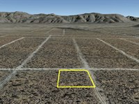
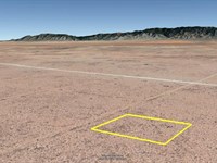
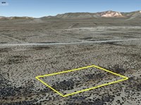
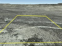
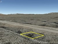
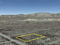
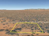
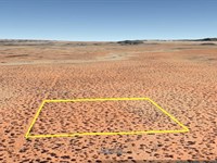
Land Description
Own your slice of Texas freedom with this 0.25-Acre parcel in El Paso County for only $110/Month. Perfect for weekend escapes, RV stays, or future investment, this flat desert lot offers wide-open views, peaceful surroundings, and easy access to nearby roads and local attractions.
Enjoy the tranquility of the Southwest while staying within reach of El Paso's conveniences-an affordable opportunity to claim your own space under the vast Texas sky.
Pricing options:
Cash Price: $1,900
Owner Finance: $2,000 - $300 doc fee/$0 down & 20 payments of $110.01
($100 Loan Payment, $10.00 Service Fee, $0.01 property tax)
• No credit check • No interest • No prepayment penalties
Note: The Doc Fee can be paid using credit or debit card. Monthly payments must be paid using ACH - checking account/routing number from a bank in the United States.
Important: While you can camp and enjoy your property while making payments, permanent residency is not permitted until the land is fully paid off. Weekend camping and recreational use are welcome.
Property details:
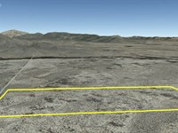
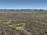
Acres: 0.25
Property ID: 155506
Legal Description: All of Lot 3 in Block 231 of Shadow Ridge Estates, Unit No. 19, according to the map and plat thereof recorded in the Office of the Clerk of El Paso County, Texas, including any gas, oil or mineral rights now owned by Grantor.
Elevation: 4,159
Topography: Flat
Roads: Dirt
HOA/POA: None
Utilities: Yes
This is off-grid land. There are no city utilities here. You can use batteries, a generator, solar panels or a windmill for electricity.
For water you can bring it with you, drill a well, have water trucked in and delivered, set up a rain catchment system
Mineral Classified Lands: according to the Texas General Land office map, this property is “mineral classified land” which means that the State of Texas owns the mineral rights and splits them 50/50 with the current surface owner.
State: Texas
County: El Paso
Property Tax: $0.07
Nearest Town: El Paso, Tx
A phone app such as Land Glide or OnX Hunt can be used to find parcel lines and corners while walking the property (if using OnX Hunt be sure to add the “TX Private Lands” map layer to see the parcel lines).
GPS Coordinates:
NorthWest Corner: 31.801228, -106.069936
Southwest Corner: 31.800986, -106.069878
Southeast Corner: 31.801089, -106.069461
Northeast Corner: 31.801278, -106.069489
Area Attractions:
Franklin Mountains State Park-El Paso
Hueco Tanks State Historic Site-El Paso
Scenic Drive Overlook-El Paso
El Paso Zoo
Ready to make this property yours? Have questions? Contact us today to start your journey to land ownership in beautiful West Texas.
Land Maps & Attachments
More Land Details
More Land from Billy Rogers
 New0.4 AC : $3.7K
- 1 AC : $1.7K
- 0.5 AC : $3.2K
- 19.8 AC : $23K
- 20.4 AC : $23K
- 0.5 AC : $3.2K
- 0.5 AC : $4K
- 0.5 AC : $7.5K
- 0.4 AC : $4K
- 11.4 AC : $11.2K
- New20 AC : $23.9K
- 0.3 AC : $3.3K