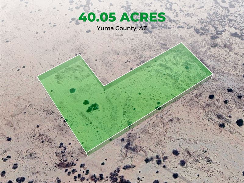
40.05 Acres of Pure RV Freedom
Ave 61 E : Dateland, AZ 85347
Yuma County, Arizona
Land Description
Calling all RVers, campers, digital nomads, and wide-open-space lovers - if you've been searching for the perfect place to park, play, and truly stretch out, this 40.05-Acre desert escape in Roll, AZ is everything your RV lifestyle demands.
This is 40 full acres of unrestricted desert terrain where you can:
Park your RV anywhere
Camp long-term with total privacy
Build your dream desert basecamp
Bring friends, toys, trailers, and gear
Explore miles of open land with complete freedom
No Hoa. No busy neighbors. No noise.
Just you, your rig, and the kind of open sky you only find in the Arizona desert.
Why RV & Camper Enthusiasts Love This Property
Boondocking Paradise
Flat, open terrain means you can pull in with any size rig - Class A, fifth wheel, travel trailer, toy hauler, or campervan - and set up camp immediately. The land is remote enough to enjoy true solitude but still close enough to supplies when needed.
Space for All Your Toys
ATVs, side-by-sides, dirt bikes, off-road vehicles - bring them all. With 40 acres, your backyard becomes your personal trail system.
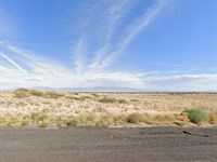
Mild Winters & Epic Skies
Enjoy Arizona's famous winter weather - ideal for snowbirds and seasonal RVers - plus jaw-dropping sunsets and crystal-clear stargazing nights right outside your camper door.
Remote, But Never Isolated
You get peaceful desert living with quick access to:
Dateland Travel Center - minutes away
Gila Bend - 54 min
Phoenix - just over 2 hours
Whether you need fuel, food, or a quick trip into town, you're never far from what you need.
Adventure Hub of the Southwest
Use this land as your launch point for exploring:
Mountain ranges
Open desert trails
Rugged off-road routes
Stargazing and photography spots
If you love the outdoors and freedom to roam, this land delivers it in every direction.
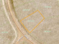
Property Details
Parcel : 17605002
Account : R0062965
Location: Off Ave 61 E, Dateland, AZ 85333
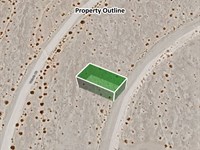
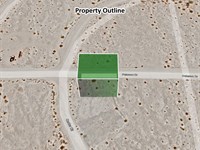
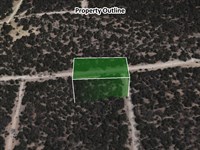
Size: 40.05 Acres
Zoning: Vacant Land (Nec)
Taxes: Only $23.84 a year
Terrain: Flat, wide-open desert
Gps: 32.85268, -113.61109
Ready to Park Your RV on Your Own Desert Playground?
This is the perfect property for anyone who wants unlimited RV freedom, long-term camping options, or a private off-grid basecamp with room to spare.
A trusted title company ensures a smooth, secure closing.
Reach out today by phone or message to claim your slice of RV paradise.
Disclaimer: Buyer is responsible for verifying all information with Grant County regarding permitted uses, access, and utilities. Buyer must obtain proper permits if needed and confirm availability of services. Seller makes no warranties or representations about the land, its condition, or what can be built on the property.
Directions to Land
From Yuma, Arizona, head east on I-8 E toward Dateland and continue for approximately 66 miles. Take Exit 55 for Spot Road. Turn left (north) onto Spot Road and drive for about 0.5 miles. Then turn right (east) onto Old US Highway 80 and continue for approximately 6.5 miles. Turn left (north) onto Avenue 71E and continue for about 1.5 miles. The destination at this coordinate 32.851720, -113.611100 will be on or near this stretch, in a rural desert area northeast of Dateland. The total driving time is around 1 hour and 10 minutes, depending on traffic and road conditions.
More Land Details
Land Price History
More Land from Lisa Foreman
 0.5 AC : $27K
- 0.2 AC : $4.2K
- 0.5 AC : $13.4K
- 2.5 AC : $31.5K
- 0.8 AC : $12.1K
- 0.1 AC : $4.4K
- 0.8 AC : $120K
- 0.4 AC : $13.4K
- 0.2 AC : $5.2K
- 0.5 AC : $8.5K
- 0.3 AC : $9.5K
- 1 AC : $5.7K