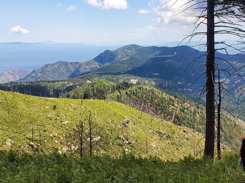
4 Acres on Top of Mt. Lemmon
12855 N Miners Ridge Rd : Mount Lemmon, AZ 85619
Pima County, Arizona
Land Description
Amazing opportunity to own 4 acres on top of Mt. Lemmon near Ski Valley and Summerhaven.
Large mountain property on highly desired Mt. Lemmon, one hour from Tucson Az.
Property Address: 12855 N Miners Ridge Rd, Mount Lemmon, AZ 85619
Latitude/Longitude: 32.442669, -110.770689
County: Pima
PRICE: Plus closing costs
This is a chance of a lifetime to own your own piece of Mount Lemmon, Az...Located on North Miners Ridge Road between Summerhaven and Mt. Lemmon Ski Valley, you are literally on top of the mountain. There are amazing views in all directions and surrounded by natural beauty and wildlife this is a dream property. Surrounded by state land you will have absolute privacy on top of Mount Lemmon. Endless outdoor recreation, whether you're hiking the many miles of trails, fishing at Rose Canyon Lake or skiing and snowboarding at Mount Lemmon Ski Valley (you can literally ski from the top of the chairlift down to your property. The access to the property is out of Summerhaven, and does require a 4x4 vehicle (road could be graded for easier access) Power to lot, needs septic and well. Don't Miss Out.
Possible uses: Single detached or one-family dwelling, accessory building, Bed and breakfast establishments, Cluster development options, Wildlife Rehabilitation Facilities, Animal Rescue and Sanctuary Facilities. Temporary mobile or manufactured home for one year while building permanent dwelling.
Property Info
Power: Available - Trico Electric
Sewer: Septic Required
Water: Drill Well
Gas: Propane Required
Telephone: Unknown
Cable: Unknown
Impact Fees Paid: No
Permits: No historical permits
Fence: No
Access: Dirt
HOA: Unknown
Violations: None
Survey: Yes
CCR's: Unknown
Property Details
Parcel Number: 222-50-0500
Property Type: Vacant Land
Lot Size: 179,932 Sq Ft
Acres: 4.13 Ac
Topography: Sloped, Rolling
Dimensions: 589' x 392' x 589' x 376'
Shape: Parallelogram
Zoned: Ml
Fema Flood Hazard Zone: D - Areas in which flood hazards are undetermined, but possible.
FEMA Floodway: Out
Yearly Tax Amount: Type: dirt (4x4 required)
Road Maintenance: None
School District: None
Legal: E590.32' N379.84' S593.42' Lucky Girl
Min Claim 4 Ac Sec 25-11-15