Off-Grid Living in Northeastern AZ
Concho, AZ 85924
Apache County, Arizona
Land Description
Owner Financing:
- down (plus the doc fee)
- down and for 72 months (plus prorated taxes and note maintenance fee)
You may have heard the old adage, give a man a fish and you feed him for a day. Teach a man to fish and you feed him for a lifetime. Or you might say, buy a piece of raw land and build a home on it and have your home for a lifetime.
You can buy your supply of goods at Walmart or Home Depot just 40 minutes away and located in Show Low, Arizona. The Bulls Market is a perfect source for your necessities at about 15 minutes to the north. Get out and have fun with your family at the nearest park located St Johns, Arizona and just 35 minutes from the area.
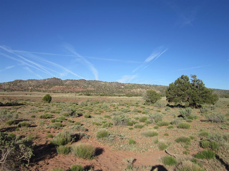
Please note: The photos represent the area around this property (they were taken of the area within a couple of miles of the property). This property is remote and the roads in the area are not good. Access can be a challenge here. When you look at google maps, it appears that there is road coming into the property from the North, however it is my understanding that one cannot access the property coming from there. There is a homeowner about a mile North that claims the road is private and doesn't want people using it. With that in mind, there are a few two-tracks coming in from the South that appear to offer access to the property, but I don't really know the exact route you would need to take to get out there. The property is best suited for investment, recreation, hunting and camping.
Subdivision: N/A
Street Address: N/A, Concho, AZ 85924
State: Arizona
COUNTY: Apache County
Zip: 85924
Size: 5 ac
Apn: 201-03-006B
Legal Description: Parcel 1 (Apn: 201-03-006B) The N 1/2 of the NE 1 /4 of the NE 1 /4 of the NW 1 /4 of Section 11, T12n, R24e, 5 Acres+/Being a portion of Apache County Assessor's Parcel Number 201-03-006 There shall be established a 20' easement along the north, south, east and west boundaries of the above said parcel - for access purpose.
Lat/Long Coordinates:
Nw Corner: 34.460792, -109.772061
Ne Corner: 34.460802, -109.769898
Sw Corner: 34.459880, -109.772061
Se Corner: 34.459890, -109.769895
Elevation: 5,916 feet
ANNUAL Taxes: Approx. per year
ZONING: General Agricultural - No time limit to build. No restrictions on dwelling size. You can build anything for residential purposes such as Single Family, Mobile or Manufactured home. Camping & RV's are okay as well (permits required for long-term stay, more than 30 days).
Hoa/Poa: N/A
Improvements: None
ACCESS: Dirt roads: In google maps, it appears that there is road coming into the property from the North, however it is my understanding that one cannot access the property coming from there. With that in mind, there are a few two-tracks coming in from the South that appear to offer access to the property, but I don't really know the exact route you would need to take to get out there.
WATER: Would be a well, water haul and holding tank or other similar option
SEWER: Would be by septic system
UTILITIES: Power by Solar or generator, Phone by cellular, Satellite Tv/Internet/Phone