Sierra Vista Retreat
10255 Boneyard Creek Road Greeley Hill Road : Coulterville, CA 95311
Mariposa County, California
Land Description
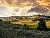
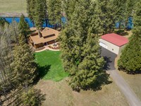
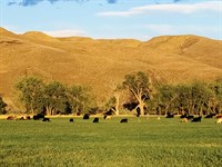
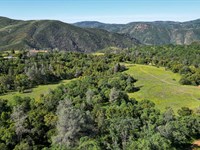
The Sierra Vista Retreat is a 21.51-Acre property in Coulterville in Historic Mariposa County. Located 1.7-Miles northeast of town, this property includes a custom designed log-style home with high quality woodworking, attached garage, and views of the foothills and Sierra. Nestled in a private area, this quiet property is centrally located along the John Muir Trail route with great access to resources and many recreational opportunities.
Land
The land ranges from 1,940' to 2,100' and has convenient, well-maintained access along Boneyard Creek Road. The property is comprised of two contiguous parcels, both accessed by the driveway. The land is gently sloped and includes oak and other native tree cover, and quality habitat for livestock and area wildlife. APNs, 6.38-Acres, 15.13-Acres Total of 21.51-Acres. Both Parcels ARE Available Individually - Contact Agent For More Information.
Improvements
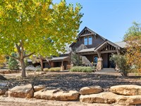
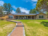
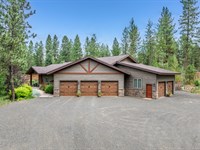
Home A nearly 2500-Sq. ft. two-story custom home with fine woodworking craftsmanship and upscale details and features. This log cabin style home has numerous upgrades including wood flooring, vaulted wood ceilings, built-in storage cabinets, high quality appliances, new mini-split Hvac units, walk-in pantry/storage, updated windows, lighting and more. The main level includes the entry area, open and spacious living room, dining area, complete kitchen, large pantry, indoor-outdoor firewood storage room, two bedrooms and full bathroom. The second floor includes the main bedroom with multiple closets including walk-in, separate adjacent full bathroom, and a large loft providing additional multipurpose space with incredible views and additional built-in storage. The finished basement includes a complete bathroom, large laundry/multipurpose room with extensive built-in cabinetry and storage. The basement has a separate exterior exit way and also connects directly to the two-car garage. The exterior of the home includes a wrap-around concrete walkway and patio with built-in cabinets, natural wood countertop with stainless steel sink and storage. A well, septic system, propane tank and newer hot water heater serves the home. A well-maintained roadway provides additional access through the adjacent parcel leading to a pad cleared for another building. This pad area has spectacular views across and through the property and to the valley, hills and mountains beyond.
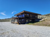
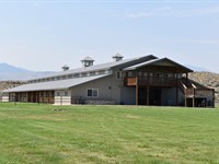
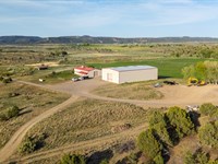
OUTBUILDINGS A wood framed metal roofed workshop/storage building is on the north side of the home and a second wood storage building is adjacent to the roadway leading to the home. There is also a well pump house building and an electrical service structure.
Buildings, structures, square-footages and other details are approximate.
Recreation
Outdoor activity opportunities in the region include hiking, hunting, fishing, off-road, biking, wildlife viewing, horseback riding and more. Other activities are available in the surrounding hills, mountains, lakes, rivers and streams of the Sierra Nevada. Horseshoe Bend Recreation Area at Lake McClure is a short 10-minute drive and Moccasin Point Marina at Don Pedro Reservoir is only 20-minutes away, both offering boating, water-sports and fishing. The nearby Tuolumne and Merced Rivers and streams flow down from Yosemite and the Sierras, providing excellent fly-fishing, as well the Stanislaus and Tuolumne Rivers. Yosemite, one of the most unique and picturesque National Parks in the US, is about a 45-minute drive, with snow skiing at Dodge Ridge east of Sonora. The West's best lakes, rivers and streams of the foothills and Sierra surround the area, with the stunning scenery of the Gold Country, Yosemite and Sonora Pass.
Agriculture
The property is well suited for horses and cattle grazing with additional ag opportunities.
Water/Mineral Rights & Natural Resources
See Title
Region & Climate
Coulterville offers year-round residents and visitors desirable climate and weather. Yosemite travelers can opt to take Highway 132, aka the Historic John Muir Trail, through Coulterville and along a scenic, laid back route to the Sierra wonderland, or travel the nearby Ca-120 entrance leading you through the charming historic town of Groveland and into a sportspersons' paradise. The region has a rich history in the gold mining era and continues to provide a Gold Country feel in the surrounding nearby communities. The Mother Lode is a narrow belt of land in east-central California ranging in elevation between 700 and 3,000 feet. Called La Veta Madre The Mother Vein by Mexican miners, it runs along the western slope of the Sierra Nevada for about 250 miles between Mariposa and Sierra City and encompasses some of the most beautiful scenery in the state. From gently rolling, chaparral-covered foothills, alive with wildflowers in the spring and lion-colored grasses in summer, to slender river gorges and wooded valleys, the scenery offers pure visual delights.
History
Coulterville is an authentic California gold rush town that was too tough to die. During its heyday, it was a major gold mining and supply center. Coulterville remains filled with historic buildings and memories of the '49ers and has been designated the California State Historical Landmark No. 332. Coulterville also serves as the base point of the John Muir Highway. George and Margaret Coulter traveled by covered wagon from Pennsylvania to California in 1849. Learning that the large number of placer miners seeking their fortunes in the three local creeks had to travel 30 miles over rough trails to get supplies, Coulter purchased a large supply of merchandise and opened business in a large blue canvas tent over which he conspicuously flew the American flag. The tent soon became a landmark to the nearly two thousand miners in the area and they called the place Banderita or Little Flag. In 1852 the discovery of gold caused the community to grow rapidly. On March 5, 1872, the name of the town was changed to Coulterville to honor its founder. The lore of gold drew miners from around the world. The Sun Sun Wo Co. Store, built of adobe in 1851, is all that remains of that area of town. Boasting to have had the crookedest railroad in the world, the original Whistling Billy locomotive now stands under the local hangman's tree next to the museum. Across the street stands the Jeffery Hotel, whose 30 thick walls, made of rock and clay binder, date back to 1851. The connecting Magnolia Room is an authentic early day saloon. In its heyday, there were twenty-five saloons and 10 hotels scattered around town. In the late 1800'S, Coulterville became a popular stopover for Yosemite bound tourists. The first paved route into Yosemite National Park ran through Coulterville, bringing the horseless carriage. This route, via Coulterville County Road 132, is still one of the shortest and most scenic ways to travel to Yosemite National Park.
Source Excerpt Nat Geo, Sierra Nevada Geotourism
Location
The property is 1.7-Miles to Coulterville, which is at the intersection of Ca-132 Greeley Hill Road and Ca-49 The Golden Chain Highway 13-miles from Groveland and a 30-min drive from Jamestown and Sonora 21-miles from La Grange to the west with Oakdale under an hour away the Sacramento International Airport is just over a 2-hr drive to the northwest. Shopping, entertainment and ranch / home resources and supplies are available in several nearby communities. The Mariposa County Coulterville fire company is located in downtown Coulterville and the nearby Cal Fire station is 2.8-Miles from the property.
Directions to Land
FROM OAKDALE: Travel east on CA-120 for approx. 36.8-miles until CA-49 splits off to the right (south) at Mocassin. Travel approx. 10.5-miles south on CA-49 until Coulterville. Turn left at the CA-49/CA-132 (Greeley Hill Road) junction and travel east for 1.4-miles to Boneyard Creek Road. Turn left at Boneyard Creek Road and travel 0.3-miles until the property.
FROM SONORA: Travel south on CA-49 for approx. 6.5-miles until the CA-108/CA-49 split. Turn left onto CA-49 and travel approximately 11.8-miles until CA-49 splits off to the right (south) at Mocassin. Travel approx. 10.5-miles south on CA-49 until Coulterville. Turn left at the CA-49/CA-132 (Greeley Hill Road) junction and travel east for 1.4-miles to Boneyard Creek Road. Turn left at Boneyard Creek Road and travel 0.3-miles until the property.
FROM MARIPOSA: Travel north on CA-49 for approx. 26-miles until Coulterville. Turn right at the CA-49/CA-132 (Greeley Hill Road) junction and travel east for 1.4-miles to Boneyard Creek Road. Turn left at Boneyard Creek Road and travel 0.3-miles until the property.
Home Details
More Land Details
More Land from Hayden Outdoors
 5,582 AC : $29.9M
- 1,222 AC : $9.4M
- 558.3 AC : $1.7M
- 114.7 AC : $2.5M
- 60 AC : $3.58M
- 263.5 AC : $1.8M
- 125.5 AC : $1.95M
- 591.3 AC : $20M
- 7,074.5 AC : $14.15M
- 11.6 AC : $1.69M
- 472.7 AC : $885K
- 28 AC : $7M