Mt. Shasta Villa
1901 Wyehka Way : Mount Shasta, CA 96067
Siskiyou County, California
Land Description
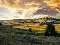
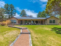
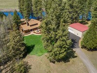
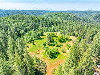
The Mt. Shasta Villa is a 6.70-Acre property in Mt. Shasta in Historic Siskiyou County. Located 3-miles west of Mt. Shasta's town center, this turnkey property includes a custom designed home, detached garage, and a second Adu, all with spectacular views. Nestled in a quiet neighborhood at the southwest flank of Mt. Shasta, this quiet retreat property is centrally located with great access to resources and endless recreational opportunities.
Land
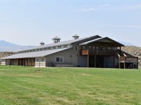
The land ranges from 3,505' to 3,640' and is adjacent to the Siskiyou Land Trust on the north and west. The property has convenient, well-maintained paved access along Wyehka Way. The property is comprised of two contiguous parcels, both of which front Wyehka Way. The land is gently sloped and includes lush conifer and other tree cover. APNs, 1.60-Acres, 5.10-Acres Total of 6.70-Acres.
Improvements
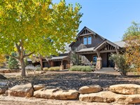
Main Home Multi-level custom designed home with many special upgrades and built-ins. New hardwood flooring, paint and other improvements/upgrades. Foyer expansive kitchen dining area great/family room multiple full bathrooms main bedroom with custom built-in bathroom with multiple sinks, shower, sunken tub, and more transition room leading to separate hot tub room, utility/laundry/bathroom and bedroom multipurpose loft room second level bedroom and bathroom numerous closets and storage areas. See floor plan images and attachments. Expansive views. Private, quiet and highly desirable area.
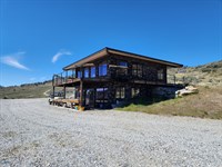
ADU Mobile home with bedroom, full bath, kitchen, dining area, living area and additional storage room annex. Includes covered wood deck entry area.
Water well, septic system and propane tank serves both the main home and Adu. Covered and exposed irrigation ditch travesrves property.
Recreation
When I first caught sight of Mount Shasta over the braided folds of the Sacramento Valley, my blood turned to wine, and I have not been weary since. -John Muir, 1874
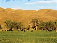
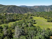
The property is located in the Historic town of Mt. Shasta at the base of the majestic Mt. Shasta mountain, one of the most iconic and beautiful peaks in the U.S. With nearly 445,000 acres of awe-inspiring wilderness, Siskiyou county is an outdoor enthusiast's dream with the ideal environment to hike, climb, fish, hunt, swim, bike, golf, explore caves and more. Castle Crags State Park is 14-miles south of town and the expansive and popular Shasta Lake is further south along Interstate-5. The area is surrounded by several national parks and refuges, including Tule Lake National Refuge to the northeast.
Agriculture
The property includes a robust variety of conifer timber and other trees.
Water/Mineral Rights & Natural Resources
Contact Listing Agent
Region & Climate
Siskiyou County is located in inland northern California, adjacent to the Oregon border. As the fifth largest county in California by area, Siskiyou County features spectacular natural beauty and scenic cities and towns including Yreka-the County Seat, Mt. Shasta, Weed, Dunsmuir, McCloud and Tulelake as well as Butte Valley, Scott Valley, Shasta Valley and the Klamath River Corridor. Next to the Appalachian region, Siskiyou County is one of the most ecologically diverse regions in the world. It sites the meeting of several western mountain ranges and the transitional mixing of various habitat types.
Mount Shasta to the east forces moisture out of the air as it rises and cools, and the dip in the Klamath Mountains allows more moisture to reach inland, so the city receives more precipitation than the semiarid region to the north. This means that in the winter, the city gets nearly 103 inches or 2.62 meters of snowfall despite its low 3,600 feet elevation. The K ppen climate classification is Csb, or warm-summer Mediterranean climate. The Usda hardiness zone is 7b.
History
For thousands of years, the Shasta, Klamath, Pit, Modoc, and Wintu tribes utilized the abundant natural resources of the Mount Shasta area. In the 1820S, Euro-American trappers and hunters followed the Siskiyou Trail-an ancient network of Native American footpaths connecting California and the Pacific Northwest-through the region. Silver and gold discoveries after 1851 attracted miners. The area was first known as Strawberry Valley, then Berryvale, with a post office opening in 1870. In 1886, the town was renamed Sisson after local businessman Justin Hinckley Sisson, who operated the Strawberry Valley Station stagecoach inn and donated land for the Central Pacific Railroad station. Completion of the railroad in 1887, along the Siskiyou Trail route, spurred tourism, logging, and population growth. Tourism and lumbering remained key industries into the 1900S, bolstered by a wave of Italian immigrants employed in timber. The city was incorporated on May 31, 1905, and officially named the City of Mount Shasta on November 10, 1925. According to the U.S. Census Bureau, Mount Shasta covers 3.8 square miles, nearly all land. A stream in the southern part of town flows into Big Springs Creek and then Cold Creek, feeding the South Fork of the Sacramento River. The town lies on the gently sloping southwest flanks of Mount Shasta, with surficial soils of Quaternary alluvium, underlain by volcanic deposits. Groundwater is shallow, with peat soil about two feet thick overlaying sand and gravel stream deposits.
Location
Mount Shasta is located at 41 18'52 North, 122 18'41 West, along Interstate-5 10-miles south of Weed and 12-miles north of Dunsmuir. McCloud is 12-miles to the east along Ca-89. Redding is about hours' drive south and the Oregon border is 70-miles north. The property main address is 1901 Wyehka Way, Mt. Shasta, CA 96067.
Directions to Land
From the City of Mt. Shasta City: Beginning at the intersection of North Mt. Shasta Blvd and West Lake Street (coordinates 41.313256, -122.312287), travel southwest on West Lake Street for 0.2-miles and turn right onto Pine Street. Travel 1.7-miles on Pine Street until North Old Stage Road. NOTE: Pine Street turns into Lassen Lane along the way. Turn right onto North Old Stage Road and travel 0.4-miles. Turn left onto Wyehka Way and travel west for 0.7-miles until the property on your right (north side of the street).
Home Details
More Land Details
More Land from Hayden Outdoors
 5,582 AC : $29.9M
- 1,222 AC : $9.4M
- 558.3 AC : $1.7M
- 114.7 AC : $2.5M
- 60 AC : $3.58M
- 591.3 AC : $20M
- 263.5 AC : $1.8M
- 125.5 AC : $1.95M
- 7,074.5 AC : $14.15M
- 251.5 AC : $950K
- 28 AC : $7M
- 472.7 AC : $885K