Kallenbach Irrigated Farm
1 24 Rd : Rolla, KS 67954
Morton County, Kansas
Land Description
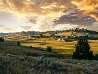
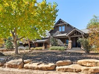
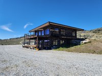
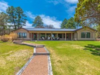
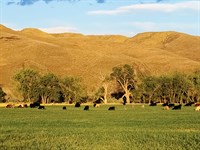
Hayden Outdoors Real Estate is pleased to offer Kallenbach Farms, an exceptional 566 acre property located in Morton County, Kansas. This productive farm features approximaitly 300 acres under center pivot irrigation, +/- 235 dry land tillable acres, two separate equipment buildings, livestock tanks, and the opportunity for big game and upland birds.
Land
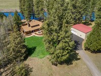
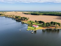
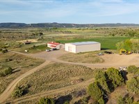
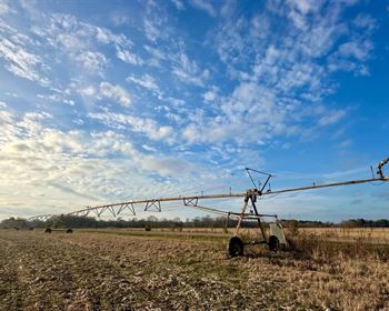
Kallenbach Irrigated Farm is a productive, contiguous property sure to catch the attention of many, from investors, hunters, and farmers alike. 566+/- contiguous farming acres with approximately 300 acres currently under center pivot irrigation, +/- 235 acres of dry land tillable, and the balance consisting of the homestead, additional equipment building, and native grasses. Offering both irrigated and dryland tillable acres of productive soils gives this property a lot of agriculture opportunities. There are currently +/- 430 acres currently planted to milo, with the open ground to be planted to either alfalfa or triticale this fall. This property features a 7 tower Zimmatic irrigation pivot as well as an additional 9 tower Zimmatic irrigation pivot that both run off of natural gas. There is electric infrastructure iser already in place should an operator wish to install an additional 5 tower pivot sprinkler. With the large quantity of water rights that come with the land, additional irrigated acres could be added. The current milo crop will pass with the land to the buyer depending on the timing of closing.
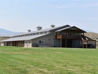
Additionally, this property features two separate shop utility buildings with concrete floors 40'x62 and 40'x50, it is well-equipped for machinery storage, maintenance, or workspace needs. The property includes blacktop access and is conveniently located near grain elevators, providing ease for hauling and logistics. The property also comes with 1,200 gallons of free natural gas annually to service the homestead, a rare and cost-saving benefit.
For livestock operations, the land includes heavy-duty catch and sorting pens, a large centrally located stock tank for grazing cattle, and several natural playas that provide additional water catch areas for wildlife. A domestic water well services the homestead, while a private pipeline delivers natural gas to the irrigation motor. The irrigation well has been recently upgraded with new bearings, a new pipe joint, and a reworked gear head. It was tested and is currently pumping a reliable 450-550 Gpm.
Recreational opportunities include antelope, mule deer, pheasant, quail, and prairie dogs. The diverse terrain and natural water features provide excellent cover and forage for wildlife, making this property a sportsman's destination and a working operation in one. Whether you're looking for a productive ag setup or a recreational investment, this property is well-positioned to meet a wide range of goals.
Yields
Crop Base Acres PLC Yield
Wheat 552.41 28
Corn 26.58 135
Average Nccpi 45.88
See attached FSA documents for more information
Well/Water Right Information Water Right File No. 10762 is permitted for irrigation of 551 acres. Authorized 317 AF at 1040 Gpm.
Water Right File No. 10675 is permitted for irrigation of 551 acres. Authorized 360 AF at 1040 Gpm.
Water rights shall pass with land to Buyer at closing.
Cropland Soils Primarily Class 3 See Map in Photos
Dalhart fine sandy loam, 0 to 1 percent slopes 175.7 Acres
Bigbow fine sandy loam, 0 to 1 percent slopes 134.16 Acres
Vorhees fine sandy loam, 1 to 3 percent slopes 94.46 Acres
Dalhart fine sandy loam, 1 to 3 percent slopes 77.17 Acres
Satanta fine sandy loam, 0 to 1 percent slopes 35.3 Acres
Lautz silty clay, 0 to 1 percent slopes, occasionally ponded 27.34 Acres
Dalhart loamy fine sand, 3 to 5 percent slopes 0.11 Acres
Property Features 2024 Taxes $4,518.30
State Hunt Unit 18
The seller does not own the mineral rights. Surface only.
Directions From Rolla, drive south on County Rd 24 for 6 miles and the property will be on the east side of the road.
13 miles east of Elkhart
20 miles southwest of Hugoton.
1 mile north of the Oklahoma border
For more detailed financial information or qualified showing, please contact J.C. Bosch or Connor Williams.
More Land Details
More Land from Hayden Outdoors
 5,582 AC : $29.9M
- 1,222 AC : $9.4M
- 558.3 AC : $1.7M
- 60 AC : $3.58M
- 114.7 AC : $2.5M
- 125.5 AC : $1.95M
- 591.3 AC : $20M
- 263.5 AC : $1.9M
- 7,074.5 AC : $14.15M
- 251.5 AC : $950K
- 11.6 AC : $1.69M
- 472.7 AC : $885K