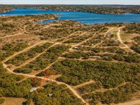
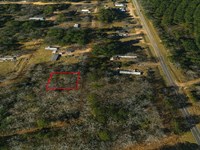
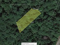
.12 Acre Near Colorado River
Tejas Trail : Burnet, TX 78611
Burnet County, Texas
Land Description
Owner Financing Available - This 0.12 acre lot is located in Burnet, Texas and the address is Tejas Trail, Burnet, TX 78611.
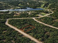
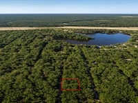
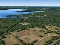
Burnet is located just northwest of Austin, Texas about 1 hour drive and next to Buchanan Lake. Buchanan Lake is the largest and the first of the Hill Country Highland Lakes, constructed in 1939. The lake covers 22,333 acres and is named for James P. Buchanan, who secured funding for the reservoir known as a real outdoorsman's paradise.
Recent job growth is Positive. Burnet jobs have increased by 2.7. Compared to the rest of the country, Burnet's cost of living is 10.5 lower than the U.S. average. The median home cost in Burnet is Real Estate $252,100. Home appreciation the last 10 years has been 12.7.
Features Close to Colorado River, paved access
Only $1900 Down and $375/Month for 57 months $23275 or Discounted Cash Price $18997
Property Details
Apn 39118
Address Tejas Trail, Burnet, TX 78611
County Burnet
State Texas
Size 0.12 Acre
Dimensions 50' x 110' x 52' x 97'
Legal S7700 Sherwood Shores III Lot 635, SEC A
Terrain Flat
Access Paved Road
Power Power in the Area Power Company Austin Energy
Water Water in the Area Burnet City Utilities Well B & B Water Well Services Inc Water Haul BH5 Trucking Services
Sewer Sewer or Septic in the Area Septic Buchanan Dam Septic Tanks Taxes per Year $121
Hoa Fees per Year $10 Annual / $0 Transfer
GPS Coordinates center at the road 30.714231, -98.388577
--- Northwest Corner 30.714248, -98.388763
--- Northeast Corner 30.714353, -98.388442
--- Southwest Corner 30.714119, -98.388707
--- Southeast Corner 30.714216, -98.388421
Elevation 860
Building Information
Zoning Tx-Burnett-Sherwood-Shores-Iii-Sec-A-Residential
Time Limit to Build No time limit to build
Site Built Homes Allowed Allowed. 500 min sqft
Modular Homes Allowed Allowed
Manufactured Homes Allowed Allowed
Mobile Homes Allowed Allowed
Tiny Homes Friendly Allowed 500 min sqft
Allowable Uses
Full-Time RV Living Allowed Not Allowed
RV on the Property While I build Not Allowed
Camping in a RV Allowed Not Allowed
Land Maps & Attachments
Directions to Land
From Burnet Consolidated Independent School District
1. Head east on TX-29 E toward Park Rd 4 W/State Park Rd 4
2. Turn right onto Park Rd 4 W/State Park Rd 4
3. Turn right onto Hoover Valley Rd
4. Turn left onto Sherwood Dr
5. Turn left at the 3rd cross street onto Apache Dr
6. Turn right onto Tejas Trail
7. Lot is on the left
More Land Details
Land Price History
More Land from Benjamin Davis
 0.1 AC : $5.5K
- 0.9 AC : $17K
- 0.6 AC : $17K
- 0.1 AC : $6K
- 0.3 AC : $5K
- 0.3 AC : $10K
- 0.3 AC : $11.5K
- 0.3 AC : $10K
- 0.3 AC : $8K
- 0.3 AC : $11K
- 0.2 AC : $7.5K
- 0.4 AC : $12K