Ohv Paradise
2 Blanco Road : El Mirage, CA 92301
San Bernardino County, California
Land Description
Only Per Month - 10.0 Acres (202) El Mirage, San Bernardino County, Seller Financing: Down Payment, Per Month, 60 Months, 10% Discount For Cash Mirage IS The OHV Capital OF Southern California. Flat 10.0 acres in El Mirage that has many possible uses including recreation (Rv/Ohv) agriculture, and investment. Or live off the grid on your own land. This 10 acres is just 10.5 miles west of Highway 395. This property has good dirt road access (see Google Earth aerials). The surrounding area has miles of roads and Jeep trails to explore. There is over 3,000 acres of BLM land 0.75 miles to the east for recreation use. You are close enough to Adelanto for easy access to food and gas, yet far enough away from civilization to enjoy the quiet solitude of the desert.
This 10.0 acre parcel is in the scenic Southern California high desert community of El Mirage. The property is an hour drive from the Riverside-San Bernardino area. You take I-15 north through the Cajon Pass then Highway 395 to Shadow Mountain Road. You then travel west on Shadow Mountain Road then south on Blanco Road for a total of 10.5 miles. You can also access this property from El Mirage Road to the south. You take Old Mirage Road (good dirt road) north to Adobe Mountain Road then north to the subject property. The total distance is about 8 miles from paved El Mirage Road. I can provide detailed directions upon request.
The parcel has RC (resource conservation) zoning that permits agricultural uses, one home or recreation use. There is no electric or developed source of water to the parcel. The parcel measures 660 feet by 660 feet containing 10.0 acres. The buyer should contact San Bernardino County to investigate all zoning and development issues for the parcel.
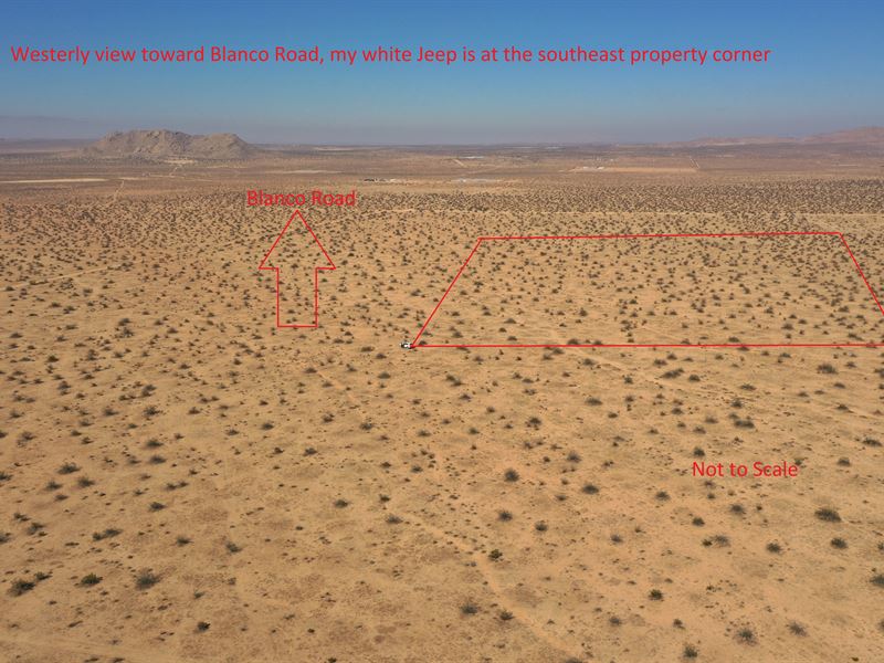
The 5 Google Earth aerial photographs show the access route from Highway 395 via Shadow Mountain Road. The GPS coordinates for the southeast property corner are 34.6914659, -117.6074972. Just copy and paste these coordinates into Google Maps using your web browser and/or put these coordinates in the Google Maps App on your smart phone and navigate to the property. You can zoom in or out using map view or satellite view to see the surrounding area.
SELLER Financing: You can purchase this parcel for with a cash down payment with the balance of financed at 7% interest for 60 months. Your monthly payment will be . The buyer and seller will each pay 50% of escrow fees and closing costs, The seller will pay title insurance. We can open escrow as soon as I accept your offer.
CASH Sale: You can purchase this parcel for cash which is a 10% discount from the seller financed price of . The buyer and seller will each pay 50% of escrow fees and closing costs, The seller will pay title insurance. We can open escrow as soon as I accept your offer.
This property is sold “as is” with no warranties given by the seller. The buyer should do their own investigation to determine if this property is suitable for their particular usage or purpose. The sale is final with no refunds for any reason.