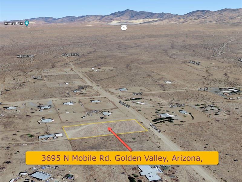
Golden Valley, AZ with Utilities
3695 N Mobile Rd : Golden Valley, AZ 86413
Mohave County, Arizona
Land Description
Great opportunity to own this 1.18 acre parcel (out of the flood zone) in Golden Valley, Arizona.
A single-Family site-built home, manufactured home, and RV's. Utilities at road, septic required.
Property Address: 3695 N Mobile Rd, Golden Valley, AZ 86413
Latitude/Longitude: 35.234431, -114.205795
County: Mohave
Subdivision: None
Directions: Head west on Az-68 W toward S Adobe Rd, Turn right onto Mobile Rd, Destination will be on the left.
PRICE: Plus closing costs
Permitted uses: Single-family dwelling, including a site-built home, a manufactured home (see Section 37.H) or a factory-built building, and RV's
Property Description
Great opportunity to own this 1.18 acre parcel in Golden Valley, Arizona. Lot is out of the flood zone, with utilities at road, septic required. A single-family dwelling, including a site-built home, a manufactured home (see Section 37.H) or a factory-built building. Located 17 min west of Kingman, AZ, 30 min east of Laughlin, NV and 1 hr 39 min from Las Vegas, NV with endless entertainment and attractions including fine dining, shopping, live shows, sporting events, and concerts. This area is seeing a lot of growth recently and is a prime location for your new home. Surrounded by endless outdoor activities whether it's hiking or biking the miles of trails throughout this area, horseback riding, Atv's, or a short distance to Lake Mead and the Colorado River for amazing water recreation.
Property Info
Power: Yes - Available
Sewer: Septic Required
Water: Available - Valley Pioneer Water Co - connection Fee
Gas: None - Propane Required
Telephone: Unknown
Cable: Unknown
Permits: No
Fence: No
Access: Public Road - Dirt
HOA: No
Violations: No
Survey: No
CCR's: No
Property Details
Parcel Number: 306-46-069D
Property Type: Residential vacant land
Lot Size: 51,559 Sq Ft
Acres: 1.18 Ac
Terrain Type: Desert
Elevation: 2883.9 feet
Topography: Flat
Dimensions: 321' x 159' x 320' x 161'
Shape: Rectangle
Zoned: AR Agriculture-Residential
Horse Property: Yes
FEMA Flood Hazard Zone: X
Fema Floodway: No
Yearly Tax Amount: Type: Dirt
Road Maintenance: County
School District: Kingman Unified School District
Legal: Roadway Easement MAP 5/20/1976 76-14578 T21n R18w SEC 4 Parcel 226-C1 (PP 17/63) Segregated As Parcel 226-C1d ON PP 19/86 5/13/2003 2003-38649 Cont 1.182 Acres 306-46-069 (306-46-069A Thru E) 2004 TAX Roll