Your Wildest Dream in Apache County
Khara, AZ 85936
Apache County, Arizona
Land Description
Owner Financing:
- down (plus the doc fee)
- down for 72 months (plus prorated taxes and note maintenance fee)
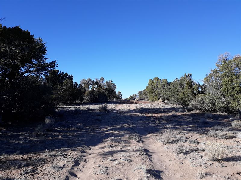
With unobstructed views to the north, this piece of scorched Arizona desert truly is picture perfect. Your 5 acres has good vegetation coverage, and although sloping, there are several flat building sites to choose from. The soil is soft sand littered with pebbles and even some Native American pottery. It's the perfect base from which to explore this stunning part of Arizona. Hunter, fisherman, snake handler? There's a little something for everyone. The weather is fine, and a rainy day will put you in a good mood. Apache County is waiting.
When it comes to lifestyle, you can carve out just about anything here. The stunning and varied natural landscape is a playground for the outdoor enthusiasts, and as they say, “any boredom you might have will evaporate in the heat”. Fortunately, sitting at an elevation of 6,050 ft, Apache County offers a higher altitude and a cooler, milder climate. If you love to fish or get out on the water, you'll be spoilt with 450 miles of river and stream, and 2,000 acres of crystal clear, cold water lakes. The wildlife is abundant, with over 400 species including antelope, elk, deer, mountain lions, black bears, and even gray wolves. Within striking distance are the majestic White Mountains, the dramatic geological formations of the Painted Desert, and the Petrified Forest National Park.
So, how will you transform your piece of Az? There is no time limit to build, and there are no restrictions on dwelling size. Tiny home, ranch, or homestead? You can build a single-family, mobile or manufactured home, and whatever you decide, just make sure it's pointed in the right direction. It would be a sin to waste views like this. In the meantime, camping and RVs are allowed, and on starry summer nights, do you need anything more than a tent?
Apache County is found in the northeastern corridor of Arizona. Witch Well Ranches is nestled between the tiny towns of St Johns and Sanders, and although secluded, you'll be within easy striking distance of civilization. St Johns, aka the ‘Town of friendly neighbors', is a 40-minute drive away, where you'll find a supermarket, a pharmacy, gas stations, and even a restaurant or two. Flagstaff is the closest major city and is 177 miles to the west. Albuquerque is 188 miles to the east. The Witch Well Tavern, which is now a drive-through liquor store, can be found just 20 minutes up the road. A godsend for a whiskey shortage.
Sitting at an elevation of 6,050 ft, the plot slopes downhill to the west with several small thin washes flowing from the southeast to the southwest, east to west and northeast to northwest. Several flat spots could serve as a building platform, and the land has low laying vegetation of cacti, juniper, and pinion. They don't call it the sandhill state for nuthin', and it's certainly got that Arizona look. From Highway 191S, access is via a dirt road, which then turns into a 2 track at the start of the property. Water for the property would be from a well, water haul and holding tank, or other similar option. There are no power posts nearby, so it might be time to go green and go solar (there's no shortage of sunshine).
There is history in the sands of Apache County, and it could be time to add a story of your own. Now is always the best time to break ground on your wildest dream. Arizona is where myth becomes reality, after all.
Subdivision: N/A
Street Address: N/A, near St Johns, AZ 85936
State: Az
COUNTY: Apache County, Az
Zip: 85936
Size: 5.00 acres
LOT Dimensions: 676 feet x 353 feet
Apn: 205-09-042N
Legal Description: SW4 SW4 SW4 NE4 of Sec 12 T17n R29e being a portion of APN 205-09-042 there is to be a 30' non-exclusive easement along the S and W boundaries of this parcel for access and utilities. SE4 SW4 SW4 NE4 of Sec 12 T17n R29e being a portion of APN 205-09-042 there is to be a 30' non-exclusive easement along the S and E boundaries of this parcel for access and utilities.
Lat/Long Coordinates:
Nw: 34.886689, -109.218347
Ne: 34.886643, -109.216116
Sw: 34.885740, -109.218340
Se: 34.885694, -109.216116
Elevation: 6,283 ft
ANNUAL Taxes: Approx. per year
ZONING: Agricultural General - No time limit to build. No restrictions on dwelling size. You can build anything for residential purposes such as Single Family, Mobile or Manufactured home. Camping & RV's are okay as well (permits required for long-term stay, more than 30 days).RV's should be at least four hundred (400) square feet, constructed to be towed on its own chassis and designed so as to be installed with or without a permanent foundation for human retail occupancy and/or dwelling residence. Camping in an RV's must be inspected by the Planning and Zoning office to ensure all plumbing and electrical is in working order prior to application approval. It could be long term as long as it was approved by the Apache Health Office.
HOA/POA: No
IMPROVEMENTS: None
ACCESS: There is a proposed road N7299 on the Western portion of the lot. Roads are mostly sand, therefore a two wheel drive vehicle is not recommended.
WATER: Would be a well, water haul and holding tank or other similar option
SEWER: Would be by Septic
UTILITIES: Power by solar, wind or generator, Phone by cellular, satellite Tv/Internet/Phone