122 Acres, Off Grid
Sawtooth Ridge Rd : Emigrant Gap, CA 95713
Placer County, California
Land Description
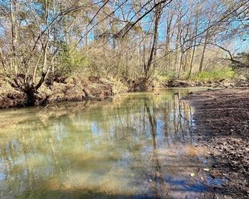
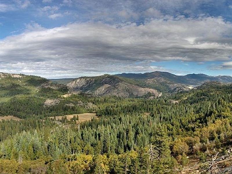
Get away from it all with this unique 122 total acres of raw land at the gateway to the Sierras. These 3 lots feature expansive mountain views from various building sites and road access to the property. This mountain retreat sits near the North Fork of the American River and spectacular vistas. Fishing holes, mountain springs, numerous species of wildflowers and trees. Note that this lot can be purchased individually or can be purchased with the two adjoining properties. Zoned Forestry and Timber Production, but flexible on building requirements. Lot 3 (17) HAS Road Access.
Uses:
Agricultural
Manufacturing and Processing
Recreation
Education and Public Assembly
Residential
Retail
Service
Transportation and Communications uses
Nearby Attractions:
AMERICAN River - 2 miles
BLACK Mountain - 13 miles
MONUMENTAL Ridge - 13.8 miles
LAKE Valley Reservoir - 20 miles
LAKE Tahoe - 55 miles
OFF-GRID Living, no neighbors for miles and miles. Guaranteed mountain views no matter where you camp or build. Septic would need to installed. No electricity now, solar system alternatives available, no gas service.
Land Data
Question/S Data
GPS Center Coordinates: Lot 1 (16) 39.221, -120.6778
Gps Corner Coordinates Lot 1 (16): 39.222022, -120.681161
39.220005, -120.681212
39.220005, -120.674322
39.222101, -120.674220
Gps Center Coordinates Lot 3 (17):
39.221, -120.6778
Gps Corner Coordinates: 39.222022, -120.681161
39.220005, -120.681212
39.220005, -120.674322
39.222101, -120.674220
Google map link:
Elevation: 5049.2 feet
If others, please specify: None
Is there a Structure (Yes or No (If Yes: Explain) No
Additional Land Info
Question/S Data
Closest major city: Colfax California 95713, USA - 1 h 25 min (40.3 miles)
Closest small town: Gold Run California 95717, Usa- 1 h 12 min (28.7 miles)
Nearby attractions: Colfax Area Heritage Museum - 1 h 25 min (40.3 miles)
Stevens Trail - 1 h 27 min (40.7 miles)
Mineral Bar Campgrounds - 1 h 32 min (43.1 miles)
Nevada County Narrow Gauge Railroad Museum - 1 h 38 min (49.1 miles)
Zoning Data
ZONING Status Overall Completion: Complete
Question/S Answers From The County
What is the zoning of the property? (Residential/Commercial/Agricultural/etc) Agricultural, Resource and Open Space Uses
Terrain type? slope
Property use code? FOR
Is the land cleared? Wooded
Access to the property? Dirt
Is the property buildable? Yes
What can be built on the property? Farmworker housing complex / dwelling unit / Caretaker and employee housing
Can we camp on the property? Yes
Notes on Camping camping is allowed
Notes on mobile homes mobile homes not allowed
Are tiny houses or small cabins allowed in the property? Yes/ No (Please ask if there is restrictions.) Yes/No No
Is there a total size restriction for any structures on the lot? Coverage: 20% maximum
Are there any building height restrictions? 36 feet maximum
What are the setbacks of the lot? f 50ft , r 30ft s 30ft
What is the minimum lot size to build on the property? The parcel size of the property will be the starting of the minimum size.
Is there any time limit to build? 6 months
Is there a County or City Impact fee required to build and if so how much does this cost? n/a
Is the property in a flood zone and if so what needs to be done to the lot in order to build? Not in the flood zone area
Any other restrictions? n/a
County Operator Details who Confirmed the Information: Zoning Information Available Online
Utilities Data
Question/S Answers From The County
Is the property in the city or MUD district?
Placer County Unincorporated Areas
Does the property have water connected? No
If No: Need to dig well
Does the property currently have Sewer or septic? No
If No: Do we need to install septic? Need to install septic
Does the property currently have electricity connected? No
What is the electric company name Solar system alternatives
What type of gas does this area service? No gas services