Double Lot at a Cul-De-Sac in MN
Tee Top Rd : Garrison, MN 55740
Mille Lacs County, Minnesota

Land Description
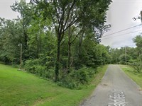
Discover the perfect blend of privacy and convenience with this double lot in Port Mille Lacs Golf Acres, tucked at the end of a peaceful cul-de-sac in beautiful Mille Lacs County, Minnesota. Just 5 minutes from HWY 169, this 0.39-Acre property offers easy access to major routes while keeping you close to the natural beauty that defines the area. Spend your weekends fishing, boating, or relaxing at Lake Mille Lacs, only 6 minutes away, or enjoy the charming lakeside community of Garrison, just 11 minutes from your doorstep. Whether you're dreaming of a vacation cabin, retirement retreat, or investment property, this prime Minnesota land offers endless possibilities in a sought-after recreational haven.
Property Information:
Apn: 09
Location: Tee Top Rd., Garrison, Mille Lacs County, Minnesota
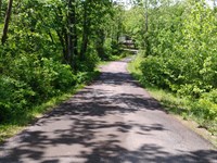
Road Surface: Paved
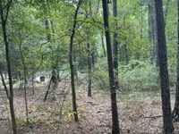
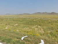
Terrain: Wooded, flat to gently rolling terrain with a gravel access path. Densely forested with mixed hardwood trees and natural
understory vegetation.
Conveyance: Warranty Deed
HOA: None
Taxes: $180 per year
Power: Contact Mille Lacs Energy Cooperative at (218)
927- 2191 for more information
Water: Would be by well
Septic: Septic but there is the possibility of connecting to
a sewer system
Camping: Allowed. Recreational Camping is allowed in the
current zoning district the property is located in. The
Mille Lacs County Development Ordinance defines
Recreational Camping as, the recreational use of
land for camping purposes whether by tent, fish
house or recreational vehicle, or a structure of less
than seven hundred fifty (750) square feet, provided
there are four (4) or fewer units on a parcel.
Recreational camping may be an accessory use or
principal use.
Types of Homes Allowed: House, modular, mobile home, or cabin are allowed - as long as they are 750 sq. ft. or larger and meet septic, well, and code requirements.
Discounted Cash Price: $19,999
Owner Financing: $22,999 - $999 Down And $394/Month For 60 Months
Land Maps & Attachments
Directions to Land
From HWY-169, Head west on Par Place toward Swing-A-Way (0.8 mi), Turn right onto Eagle Flight (0.3 mi), Turn right onto Birdie Bend (328 ft), and Turn right onto Tee Top (0.2 mi). The property is at the end of the cul-de-sac
More Land Details
More Land from Scott Bossman
 0.4 AC : $20K
- 0.3 AC : $3.1K
- 0.3 AC : $3.1K
- 0.3 AC : $3.1K
- 0.3 AC : $3.1K
- 0.2 AC : $11K
- 2.9 AC : $6.5K
- 0.4 AC : $11K
- 0.2 AC : $2.6K
- 5 AC : $7.9K
- 1 AC : $4K
- 0.3 AC : $3.5K