McCord Tract
Centre, AL 35960
Cherokee County, Alabama
Land Description
Property Overview
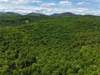
McCord Tract is a secluded 20-acre timber and recreational property in Northeast Alabama's Piedmont region featuring:
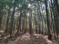
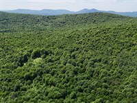
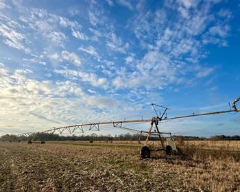
-20 acres of 23-year-old loblolly pine plantation ready for thinning or harvest
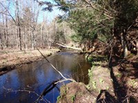
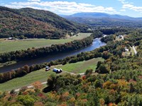
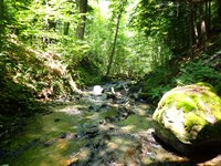
-Less than a half mile from Lake Weiss and the Coosa River
-Surrounded by productive timberland with abundant wildlife
-Accessible in 10 minutes from US Hwy 411, near Cave Springs, GA and Centre, Al
-Strong timber investment potential with recreational opportunities
Location
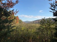
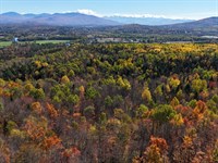
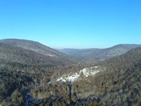
The McCord Tract lies in the upper Piedmont region of northeast Alabama, just south of the Appalachian Mountains' southernmost ridges. The surrounding valleys are in farmland and timber production, while the ridges hold natural stands of mature mountain hardwoods. The property is bordered by other timber-producing tracts, contributing to its seclusion and wildlife habitat.
Lake Weiss and the Coosa River are less than half a mile away, offering excellent recreational opportunities alongside the nearby state and national parks. The tract is about 10 minutes from US Highway 411. The town of Cave Springs, Georgia is only 8 miles to the southeast and provides grocery, fuel, and dining options. Centre, Alabama is about 25 minutes west with additional amenities including hotels, shopping, dining, and medical facilities. Several small airports serve the area, while Huntsville and Birmingham airports are each about an hour's drive. Atlanta's international airport is roughly an hour and a half away.
Access
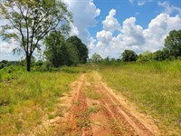
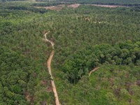
At present, McCord is accessible by permission crossing other properties. Showings must be by appointment to ensure the neighbors are alerted appropriately. Its primary access is a logging road owned by a timber company. The logging road meets public frontage on Cherokee County Road 101 in about a mile and a quarter. Power is available along CR 101. The logging road
crosses the McCord tract, giving it about 750 feet of interior road. The logging road itself is in good condition from CR 101 to the powerline right of way, but it needs maintenance from the powerline to the boundary of McCord. UTV or 4×4 with good clearance is needed to access the tract.
Property Description
This tract has been in timber production under the current ownership and is used for recreation. Access is currently by permission crossing other landowners; however, if legal access can be obtained, that will open the door to residential use. This property has relatively flat terrain with elevations ranging from 580 to 600 feet. Soils are very well drained and suitable for timber production. Since it is surrounded on all sides by other timberland, game species thrive in the area.
Timber Resource
A timber inventory was conducted in the summer of 2025. The current owner's property manager provided timber volumes. Product values were applied by F&W Forestry Services, Inc. Volumes and values are not guaranteed.
The entire tract is comprised of 23-yearold loblolly plantation that has not been thinned. This plantation is ready to thin, or can be allowed to grow until final harvest. If timber production is the primary objective, it should be allowed to grow for another 2 to 5 years.
During that time, much of the pulpwood volume should grow into higher product classes such as chip-n-saw and sawtimber. It would be expected to reach financial maturity between the ages of 25 and 28 in this market region, which should be the opportune time to harvest. After harvest, replanting with loblolly pine is recommended for ongoing production. Herbicide and fertilizer applications can further enhance growth and investment returns. If the primary objective is wildlife or aesthetics, thinning combined with prescribed burning is advised. A burn every 2 to 3 years improves wildlife habitat, reduces wildfire risk, and enhances visual appeal.
Land Maps & Attachments
Directions to Land
Please contact us to schedule a showing. Access is by permission only, so we will provide directions and visiting instructions just ahead of meeting.
More Land Details
More Land from Thom Milke
 582 AC : $1.92M
- 87.7 AC : $203K
- 54 AC : $850K
- 238.1 AC : $595K
- 515 AC : $705K
- 9.8 AC : $155K
- 91.1 AC : $462K
- 256 AC : $920K
- 88.5 AC : $359K
- 1,184 AC : $2.87M
- 241 AC : $2.9M
- 130 AC : $261K