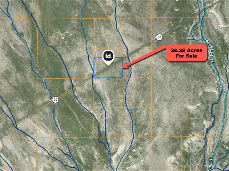
26.38 Acre Desert Parcel on Highway
Grouse Creek, UT 84083
Box Elder County, Utah
Land Description
This 26.38-Acre desert parcel offers rare paved state highway frontage in northwest Utah. The long rectangular tract sits directly on State Route 30 about 4 miles east of Grouse Creek in Box Elder County, with approximately 1,300 feet of highway frontage and 880 feet depth. With level, open terrain and unobstructed mountain views, it's an ideal site for a homestead, RV pad, small ranch or off-grid cabin. Agricultural zoning allows a wide range of uses, including farming, grazing and low-density residential. There are no subdivision covenants or HOA restrictions, and 2024 property taxes are only about $23 per year.
Utilities are not yet on site; most owners use wells, septic systems and solar or generators. GPS coordinates 41.40006 N, -113.95181 W mark the center of the property. The legal description is "S 2/3 SW 1/4 NE 1/4 Sec 19 T8 N R18 W Slm Cont 26.38 Acres." Box Elder County parcel number 02.
Cash price is $14,900 plus closing costs and tax reserve. Owner financing is available: purchase price $17,900 with 20% down (approx. $3,580) plus closing and tax reserve, 12.99% interest, and a $35 monthly servicing fee. Estimated monthly payments are around $717 for 24 months, $519 for 36 months or $421 for 48 months.
Nearby attractions include Nancy Holt's Sun Tunnels (8 mi), Devils Playground (25 mi), City of Rocks National Reserve (50 mi), Golden Spike National Historical Park (74 mi) and Bear River Migratory Bird Refuge (94 mi). For groceries and services, Tremonton is about 120 miles east; Brigham City (~130 mi) and Salt Lake City (~150 mi) offer broader amenities.
Land Maps
Directions to Land
From Grouse Creek, drive east on paved State Route 30 for approximately 4 miles. The parcel is on the north side of the highway between SR-30 and Winter Cabin Road, with roughly 1,300 feet of frontage. Approximate coordinates are 41.40006 N, -113.95181 W.