Belvidere Forest
Belvidere, VT 05442
Lamoille County, Vermont
Land Description
Property Overview
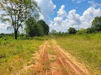
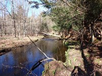
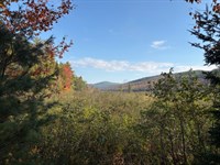
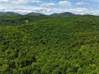
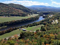
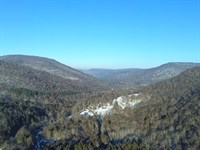
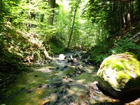
Located off Bog Road in the quiet, rural town of Belvidere, Vermont, this property boasts a well-managed and diverse timber resource valued at $336,700. The forest primarily comprises healthy maple and birch stands, with pockets of softwood that add to its ecological diversity and long-term value. Two access points serve the property, including a westerly entrance with a built gravel driveway leading to a spacious open landing ideal for a seasonal camp, recreational base, or future log landing. You'll enjoy scenic views of the Cold Hollow Mountains from select vantage points. Just minutes from the property, the North Branch of the Lamoille River meanders through town before joining the main stem in Cambridge, approximately 25 minutes away. Cambridge is home to Smugglers' Notch Resort, a premier Vermont ski destination, and the renowned Smugglers' Notch Distillery.
Location
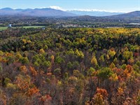
The property is situated on Bog Road in Belvidere, just north of the village center, in a landscape defined by scenic beauty and minimal development. The area features only a handful of main roads, numerous natural streams, and uninterrupted ridgelines, creating a sense of true Vermont wilderness.
Just 1.5 miles to the east, Vermont's iconic Long Trail, which runs the length of the state, crosses Vt-109. This section of the trail is surrounded by thousands of acres within Long Trail State Forest, offering ponds, hiking trails, and designated campsites.
To the north, the quaint village of Montgomery serves as a gateway to Jay Peak Resort and is located only about 6 miles away. For additional shopping, dining, and services, the towns of Johnson and Cambridge are just 25 minutes to the south and west.
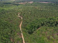
Access
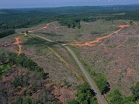
Access to the property is via Bog Road, a hybrid Class 3/4 roadway maintained during the summer months. The parcel enjoys approximately 3,200 feet of road frontage, providing multiple access possibilities. Two established log landings (one featuring a developed gravel driveway) serve as convenient entry points, with an internal network of woods trails extending from these landings into the heart of the property.
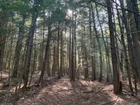
Timber Resource
Timber data in this report are based on a timber inventory conducted in the spring of 2021, which assisted in establishing Capital Timber Value (Ctv). 60 inventory points were sampled (1 plot per 4.35 acres), covering a 446' X 446' grid using a 10-factor prism. Sampling statistics are ±14.7% standard error for sawlog products and +/-12.2% for all products combined at a 95% confidence interval. Timber was grown forward 4 growing seasons using current FIA timber growth data.
The timber data reveal a total sawlog volume of 1,280 MBF International ¼” scale (4.8 Mbf/Acre), with 3,466 pulpwood cords (13.3 cords/acre). The combined total commercial per-acre volume is 22.9 cords, which is an average figure for the region. stumpage values were assigned to the volumes in 2025, producing a property-wide Capital Timber Value (Ctv) of $336,700 ($1,277/Commercial acre). See the Timber Valuation in this report for details.
Species Composition
The species composition is dominated by hardwoods (94%), with softwoods holding the balance (6%). The combined composition of all products offers a diverse mix, led by sugar maple (29%), followed by yellow birch (28%), and red maple (22%). The sawlog volume breakdown is similar, consisting of yellow birch (35%), sugar maple (33%), red maple (17%), spruce/fir (3%), and white ash (5%). The softwood species component (mostly red spruce sawlogs with larger diameter stems) occupies a small mixedwood stand at the land's northeastern end.
Stocking & Stem Quality
Forest density is generally represented by fully stocked stands covering most of the acreage. The exceptions are in the western and southwestern sections of the forest, where stocking is still below full conditions. The average Basal Area (Ba) is 78 ft2 on 140 stems/acre. Stem quality is generally quite good with Acceptable Growing Stock BA at 63ft2. The highest quality stems are in pole-sized growing stock and smaller hardwood sawlog components. The larger sawlogs fall short of veneer quality but offer straight, tall stems.
Land Maps & Attachments
Directions to Land
From the Village of Belvidere Town Hall, proceed north on VT-109 approximately 0.5 miles, then turn right on Bog Road. Proceed east on Bog Road about 2 miles before finding the property on your right.
More Land Details
More Land from Thom Milke
 582 AC : $1.92M
- 87.7 AC : $203K
- 54 AC : $850K
- 238.1 AC : $595K
- 515 AC : $705K
- 9.8 AC : $155K
- 91.1 AC : $462K
- 270 AC : $800K
- 1,184 AC : $2.87M
- 241 AC : $2.9M
- 256 AC : $920K
- 88.5 AC : $359K