Camp Hill 9
Camp Hill, AL 36850
Tallapoosa County, Alabama
Land Description
Location
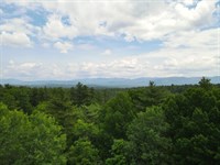
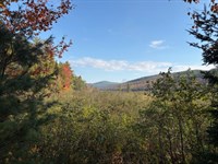
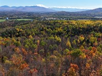
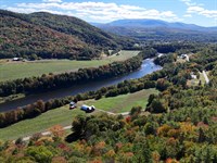
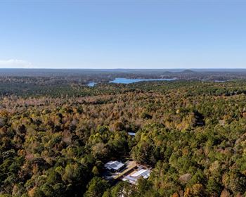
The Camp Hill Tracts are located in the Piedmont region of Alabama, known for its rolling hills and valleys. These tracts are situated within a heavily timbered area of Tallapoosa County, surrounded by additional timberland on nearly all sides. Tracts 1 and 12 have direct frontage on US Hwy 280. The city of Dadeville is just a 5-mile drive away, offering options for dining, groceries, and fuel. The cities of Auburn and Opelika, Alabama, are approximately 20 minutes to the southeast and provide more dining choices, grocery stores, hotels, shopping, hospitals, and access to Interstate 85. The Tallapoosa River and Lake Martin can be reached within 20 minutes. Also, the Atlanta Airport is less than an hour and a half drive away.
Access
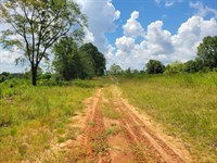
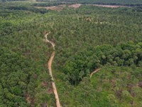
The Camp Hill tracts have entry points from various public and private roads. Lower Sandy Road and Slaughter's Crossing Road are retired, county-maintained dirt roads that are in good condition. Each tract includes internal woods roads suitable for access, although some require a 4×4 vehicle or Utv. All tracts have direct access to electricity, with the exception of Tract 11.
-Tract 1 features 1,850 feet of frontage on US Hwy 280 and 1,290 feet along Lower Sandy Road, which forms its eastern boundary.
-Tract 2 features access from Lower Sandy Road, with 3,200 feet of frontage forming its eastern boundary, plus three-quarters of a mile of interior woods roads.
-Tract 3 features 780 feet of frontage on Slaughter's Crossing Road, where power is available, and 4,650 feet along Lower Sandy Road forming its eastern boundary, plus three-quarters of a mile of interior woods roads.
-Tract 4 is accessed from Slaughter's Crossing Road, on which it has 1,100 feet of frontage. Power is available along this road. It has additional frontage along a portion of Slaughter's Crossing that is retired from county maintenance. It has a mile of interior wood roads.
-Tract 5 features 3,150 feet of frontage along Slaughter's Crossing Road and about half a mile of interior woods roads.
-Tract 6 features 1,700 feet of frontage along Railroad Avenue and Bond Spur Road and over half a mile of interior woods roads.
-Tract 7 features 3,300 feet of paved frontage on Railroad Avenue and 2,200 feet along the dirt Bond Spur Road, plus a quarter mile of interior woods roads.
-Tract 8 features 5,700 feet of paved frontage on Railroad Avenue and 1,990 feet along Bond Spur Road, plus a mile of interior woods roads.
-Tract 9 features 5,990 feet of frontage on Sandy Road and Slaughter's Crossing with 2.5 miles of interior woods roads and trails.
-Tract 10 has public access to Rogers Street and nearly a mile of interior woods roads.
-Tract 11 features 1,340 feet of frontage on Lower Sandy Road forming the western boundary, plus 1.25 miles of interior woods roads.
-Tract 12 features 730 feet of frontage on US Hwy 280 and 5,060 feet along Lower Sandy Road forming the western boundary, plus a quarter mile of interior woods roads.
Property Description
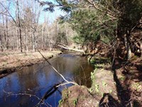
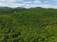
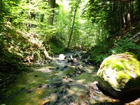
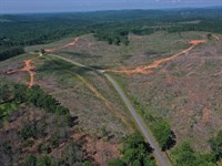
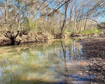
The Camp Hill Tracts provide an outstanding opportunity for timber investment, recreation, and rural living, all within close proximity to the Tallapoosa River and Lake Martin. Each property features gently rolling terrain and well-drained soil, making it ideal for timber production. The diverse range of timber types supports long-term forest management and attracts abundant wildlife. With access to creeks and natural water sources, all twelve tracts offer both aesthetic appeal and practical function, making them perfect for activities like hunting, camping, or future homestead development. Additionally, convenient access to US Hwy 280 and existing internal infrastructure paves the way for potential development, whether constructing ranchettes or creating a high-end recreational retreat.
Timber Resource
The Camp Hill Tracts have been effectively managed for both timber and wildlife. Each tract has been cultivated for timber production through the establishment of loblolly pine plantations, featuring stands of pine at various ages and stages of development. It is recommended that these tracts continue to be managed in this manner if generating timber income remains the primary objective, as loblolly pine is the preferred tree species for maximizing returns in this market region.
Typically, the management regime for loblolly plantations involves thinning at ages 15 and 21. The final harvest occurs between the ages of 28 and 32, depending on growth rates, development status, and market conditions. After harvesting, it is advisable to replant loblolly pine to maximize return potential. Fertilization and herbaceous treatments can be applied throughout the lifespan of a loblolly plantation to enhance growth.
For landowners who prioritize wildlife habitat or aesthetic values, it is recommended to thin existing loblolly stands or replace them with longleaf pine, accompanied by a prescribed burning cycle every 2 to 3 years. This approach improves habitat quality by opening the canopy, enhancing forage availability, reducing wildfire risk, and clearing residual debris.
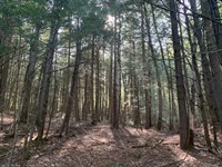
Additionally, several tracts contain hardwood bottomlands rich in mast-producing oaks located along creek corridors. These areas are ecologically valuable, serving as wildlife corridors and food sources. It is best to leave these areas intact to preserve their environmental benefits.
-Tract 1 features 50 acres of 8-year-old loblolly that should be ready to thin in 6 to 7 years, and 8 acres of hardwood bottomlands. It also has approximately 12 acres of mature timber, serving as a visual buffer to US Hwy 280.
-Tract 2 features 145 acres of young loblolly, 39 acres of hardwood bottom, and 5 acres of powerline right of way, which offers wildlife enhancement opportunity.
-Tract 3 features 85 acres of young loblolly pine of various ages. There are 26 acres of 15-year-old pine ready for thinning. This tract also has 26 acres of bottomland hardwood.
-Tract 4 features 104 acres of young loblolly and 17 acres of 15-year-old pine ready to be thinned. There are 6 acres of bottomland hardwood.
-Tract 5 features 90 acres of 11-year-old loblolly ready for thinning in about 4 years and 6 acres of bottomland hardwood.
-Tract 6 features 103 acres of plantation that will be ready to thin in about 4 years and 14 acres of hardwood bottom.
-Tract 7 features 91 acres of various ages of young loblolly pine that are approaching thin readiness. There are 13 acres of bottomland hardwood.
-Tract 8 features 197 acres of various ages of young loblolly pine approaching thin readiness. These multiple age classes increase diversity and enhance wildlife value.
-Tract 9 is the largest of the tracts offered. It has 353 acres of plantations of various ages, ranging from three-year-old saplings to 21-year-old stands ready to be second thinned or clear-cut. It boasts 76 acres of hardwood and plenty of water resources.
-Tract 10 features 39 acres of seven-year-old loblolly and boasts 76 acres of hardwood bottoms, including direct North Fork Sandy Creek access.
-Tract 11 features 176 acres of young loblolly plantations and 18 acres of 21-year-old pine ready for thinning or final harvest.
-Tract 12 features 110 acres of young loblolly at various stages approaching thinning age and 8 acres of pine that are 21 years old and ready for thinning. There are 55 acres of hardwood bottomlands. It also has approximately 4 acres of mature timber, serving as a visual buffer to US Hwy 280.
Land Maps & Attachments
Directions to Land
From Exit 58 off of I-85, follow US Hwy 280 north for 23.5 miles. The entrance will be on the right just about a mile after the junction of US 280 and AL Hwy 50. Turn right onto Lower Sandy Road. Follow for just under a mile and a half, the property will be on the right. Call for combos.
More Land Details
More Land from Thom Milke
 256.3 AC : $387K
- 582 AC : $1.92M
- 87.7 AC : $203K
- 54 AC : $850K
- 238.1 AC : $595K
- 515 AC : $705K
- 91.1 AC : $462K
- 9.8 AC : $155K
- 241 AC : $3.5M
- 88.5 AC : $359K
- 256 AC : $920K
- 270 AC : $800K