Sugar River Forest
Cash Street : Croydon, NH 03773
Sullivan County, New Hampshire
Land Description
Property Overview
The property's highest and best use is flexible, including opportunities for timber investment, home construction, and as a launching point for nearby downhill skiing and scenic lakes. This land has been family-owned and managed for 66 years, with a strong focus on sustainable forest management, resulting in an exceptional timber resource that is rarely seen on the market. Property highlights include:
-A mature, high-quality timber resource with a standing timber value of $1,391,000.
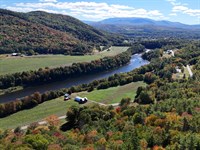
-Extensive frontage along the North Branch of the Sugar River.
-Access via a quiet town road, offering various building and subdivision opportunities.
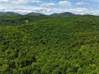
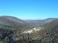
-Diverse terrain characterized by upland slopes, including the 1,670-Foot Jackman Ridge.
-A prime location near Mt. Sunapee Ski Resort, a regional hospital and airport, as well as vibrant job markets.
-Easy access from Interstate I-89 and Route 10.
Location
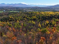
The property is situated in the west-central region of New Hampshire, which boasts a robust job market, ample undeveloped forest land, and numerous lakes and ponds. Easy access to the regional hospital, airport, employment opportunities, and recreational amenities is available via nearby NH Route 10, which connects to I-89 at Exit 13, just a 9-minute drive to the north. The surrounding landscape is predominantly forested, with businesses located along the Route 10 corridor, along with scattered homes on town roads. Locally, on Cash Street, residences are widely spaced before becoming more clustered along the shores of nearby lakes and ponds. Rockybound Pond is located 1.6 miles to the north, while The Overflow and Perkins Ponds are less than 3 miles to the south. Lake Coniston, Ledge Pond, and the expansive 4,125-Acre Lake Sunapee are within 5 miles to the west. For winter activities, downhill skiing at Mt. Sunapee is just a 20-minute drive away. The town of Newport, located a 12-minute drive away, offers a full range of retail amenities. Additionally, Lebanon, home to Dartmouth Hitchcock Medical Center and Lebanon Regional Airport, is 19 miles to the northwest, with Boston situated a 2-hour drive away.
Access
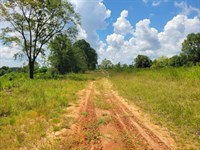
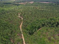
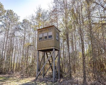
The land has +/-1,600' of frontage (covering two separate locations) along the town-maintained, gravel-surfaced Cash Street, where electric power appears to run along this road. Access to all of the land west of Cash Street is provided by a developed driveway at the sharp turn in Cash Street before the road leaves the property. From this driveway, various woods trails feed out to the west, south and north. Additional access is provided off Route 10 via Glidden Lane, where a discontinued bridge crosses Sugar River. The bridge abutments and underlying steel remain at this river crossing; however, future use of the bridge will require considerable upgrades and likely permits.
The +/-185 acres east of Cash Street is accessed from Kemp Road, where the discontinued Stagecoach Road leads south into the property. There is also +/-183' of frontage along Cash Street at the northern tip of this section of land; however, it does not seem to have been used in the past for access.
Property Description
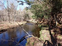
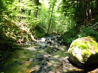
The land's diverse geographic attributes offer an ideal landscape for the outdoor enthusiast, while the less-traveled Cash Street access provides various future homesites with easy access to Route 10 and nearby towns. The North Branch of the Sugar River creates the property's western boundary for approximately 1.1 miles, running slowly along the land's northern frontage and then shifting to faster water with deep pools and large boulders as it leaves the property. The North Branch is stocked annually with brook and rainbow trout, offering excellent spring opportunities for fly-fishing anglers.
The full length of the North Branch is 10 miles, beginning to the north at the confluence of Sawyer and Stocker Brooks in Grantham. From this source, the river flows south through the town of Croydon, reaching the main branch of the Sugar River in the town of Newport. In Croydon, the river flows through the 40-acre Spectacle Pond, which is located just north of the property. Route 10 follows the North Branch for nearly its entire length.
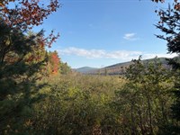
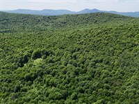
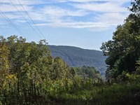
The topography is shaped by the land's southern boundary along Jackman Ridge, which includes Baltimore Hill, a prominent 1,670-Foot local peak, offering an excellent hiking destination with scenic views after tree clearing. Along the way, maturing, dense softwood stands create a scenic hike. From Jackman Ridge, most of the terrain gradually falls (with a historic homestead mid-slope along the way) to the Sugar River, whose elevation is 886feet. The majority of the terrain moderately slopes (with occasional rock outcrops), creating well-drained upland soils and good internal access conditions. The exceptions are some steep slopes south and east of Baltimore Hill, along with an 8-acre wetland at the eastern base of Baltimore Hill.
Timber Resource
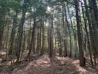
Acquired in 1959 by the ownership, the land has been professionally managed as a long-term timberland property. Sustainable silvicultural practices have guided the management, producing the high-quality, fully stocked stands that exist today.
Timber data in this report are based on a comprehensive timber inventory conducted by F&W Forestry Services in April of 2025,With the purpose of establishing Capital Timber Value (Ctv). 124 inventory points were sampled (1 plot per 6.4 commercial acres), covering a 532' X 532' grid using a 15-factor prism. Sampling statistics are ±11.4%Standard error for sawlog products and+/-8.8% for all products combined at the95% confidence interval. The timber data Sawlog Volume by Species reveals a total sawlog volume of 6,789 MBF ¼” scale (8.6 Mbf/Commercial acre), with 20,214 pulpwood cords (25.5 cords/commercial acre). Combined total commercial per acre volume is 42.6 cords, a figure well above the average for the region. Stumpage values were assigned to the volumes in April of 2025,Producing a property-wide Capital Timber Value (Ctv) of $1,391,800 ($1,754/Commercial acre). See the Timber Valuation in this report for details.
Species Composition
The species composition consists of 68% hardwoods and 32% softwoods. The leading species for all products combined are red oak and red maple, each comprising 20% of the total. This is followed by hemlock at 17%, white pine at 12%, and birches at 11%.Additionally, there are various other hardwoods, including white ash at 9% and sugar maple at 8%, along with miscellaneous softwoods, primarily red spruce, at 3%.
The sawlog volume breakdown is led by red oak and white pine (49%), followed by other common associates found within this region on well-drained soils (see Sawlog Volume by Species graphic). The primary species found on the property have all benefited from strong historical (and current) markets for their various end products, ensuring the likelihood of robust asset appreciation from future stumpage value price growth.
Stocking & Stem Quality
With the exception of areas harvested in 2022 (within the central portion of the land), forest density is represented by overstocked stands. The average Basal Area (Ba) is 133 ft on 219 stems/acre. Stem quality is well above average within all size classes.
Sawlog Value & Thinning History
Sawlog value is dominated by red oak (43%), followed by white pine (16%), and red/sugar maple (21%), with the balance held by common associates, including red spruce. A forest harvest operation was conducted in +/-2022 in the central section of the land, removing white ash trees and thinning elsewhere. The remainder of the forest was last thinned+/-35 years ago, where stocking levels are high.
Diameter Distribution
The sawlog volume breakdown is led by red oak and white pine (49%), followed by other common associates found within this region on well-drained soils (see Sawlog Volume by Species graphic). The primary species found on the property have all benefited from strong historical (and current) markets for their various end products, ensuring the likelihood of robust asset appreciation from future stumpage value price growth. Average diameter for all products combined is +/-15.5”, while the average sawlog diameter is nearly17”. Average diameter for red oak is +/-17.5” and white pine +/-21.5”,Both representing a mature age class for their respective species. The diameter distribution indicates a wide range, with strong representation from the mid to mature age classes, offering immediate income opportunity from future harvesting.
Land Maps & Attachments
Directions to Land
From Coniston General Store along Route 10 in Croydon (address 870 NH-10) head east on Pine Hill Road for +/-400' to Cash Street. Then travel south on Cash Street for +/-1.9 miles to the property driveway on the road's west side (just before the road's sharp turn).
More Land Details
More Land from Thom Milke
 582 AC : $1.92M
- 87.7 AC : $203K
- 54 AC : $850K
- 238.1 AC : $595K
- 515 AC : $705K
- 9.8 AC : $155K
- 91.1 AC : $462K
- 1,184 AC : $2.87M
- 256 AC : $920K
- 88.5 AC : $359K
- 130 AC : $261K
- 80 AC : $154K