Land in Ashe Nc, $629 Now
Grassy Creek, NC 28631
Ashe County, North Carolina
Land Description
Owner Financing:
- down (plus the doc fee)
- down for 60 months (plus prorated taxes and note maintenance fee)
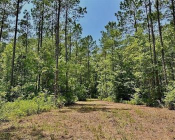
1.13 Acres - Paved Road Frontage, Power at the Road, Easy Owner Financing - Ashe County, Nc
Your foothold in the mountains starts here.
You want your own spot - not another rental, not another long weekend in someone else's space. Just a place that's yours. Simple, reachable, and solid.
This 1.13-Acre lot sits on a quiet stretch of paved road in Ashe County, near Grassy Creek and just minutes from the Virginia line. It's mostly cleared with wide-open mountain views, a soft slope, and space to use right away.
Whether you're visiting or holding for the future, this one is easy to walk and easy to picture yourself on.
What Makes This Lot a Smart Buy:
1.13 acres - mostly cleared with open views of the mountains
Direct road frontage
Power lines run along the road (buyer to confirm setup)
Gently sloped and open -
No buildings or improvements - clean and ready
Zoned as vacant land (RA - Residential Agricultural)
A Simple Way to Own It
You don't need perfect credit. You don't need a bank. You don't need to wait.
for 60 months
non-refundable doc fee
Taxes and note servicing added monthly
Early payoff is always an option
We make the process fast, honest, and personal.
Where You'll Be
4.7 miles to Grassy Creek
2.5 miles from the Virginia border
About 30 minutes to Jefferson & West Jefferson
1 hour to Boone
Near Nc-93 and Nc-88 - easy routes in and out
This is the kind of place you can get to without hassle - and one you'll want to come back to again and again.
What You'll See
Mostly cleared, open ground with soft slope and a wide view toward the hills. There's no driveway or development - just clean terrain and room to breathe. You can walk it, stand still in it, and see potential in every direction.
Come Take a Look
We'll send you the GPS coordinates and a quick map - no pressure, no appointments. Just head out when it works for you.
If This Land Feels Right, Don't Wait
The good ones - with road frontage, views, and flexible terms - don't stick around. Reach out now to get all the info, ask questions, or lock it in.
No pressure. No middlemen. Just land - your land - when you're ready.
State: Nc
County: Ashe
Zip: 28631
Size: 1.13 acres
Apn: 6
Legal Description: Being Lot 16 as shown on a Plat entitled "Chincoteague" of record in the Ashe County Public Registry in Plat Book 6 at Page 421, to which recorded plat refernce is made for a metes and bounds description of said Lot
Lat/Long Coordinates:
Nw: 36.558666, -81.386532
Ne: 36.558619, -81.386371
Sw: 36.557899, -81.387275
Se: 36.558199, -81.386122
Elevation: 2835 feet
Annual Taxes: Approx. per year
Zoning: No Zoning
Flood Zone: No
HOA/POA: No
Improvements: No improvements done.
Access: Paved Road
Water: Will need to install a Well
Sewer: Will need to install a Septic System
Utilities: Electric, Internet, Phone
Owner Financing:
- down (plus the non refundable doc fee)
- down for 60 months (plus prorated taxes and note maintenance fee)
We do not offer owner financing for residential use or full-time living on the property during the financing term.