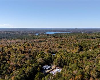
Morrison Brook Forest
Whee, VT 05851
Caledonia County, Vermont
Land Description
Morrison Brook Forest represents an exceptional commercial sugarbush opportunity where high concentrations of maturing maple occupy terrain that slopes to the paved access points. Electricity is available roadside to run a modern sugarbush operation and capture all of the property's sap production.
Investment highlights include:
- Species dominated by maple (50%);
- Total taps estimated to be 69,000, representing an average of 55 taps/acre, with many stands offering ±85 taps/acre;
- Fully-stocked overstories, with established maple regeneration;
- Electric power near the paved road frontage (at the land's lowest elevation), with developed internal roads and trails;
- Existing ±11,000 taps on 123 acres set up with tubing and collection area;
- Timber value estimate to be with a considerable mature white ash component ready for harvest (value over property is located in the north-central part of Vermont, in the rural town of Wheelock, which is mostly forested with small farms in the valleys. The town is framed by Interstate 91 and Route 122 to the east and Route 16 to the west. The property sits on the west side of town along Route 16. This local area is home to many successful, grass roots businesses including Hill Farm Brewery (one of the country's premier craft breweries), Nanah Cub Farms (craft soap and herbs), Leaning Maples Woodcraft (custom wood artist), Hillcrest Nursery, Green Mountain Monastery (meditation and eco-zoic philosophy) and the Museum of Everyday Life (an eclectic collection of art, displays and artifacts). The property sits between the towns of Hardwick (12 miles to the south) and Barton (11 miles to the north). Boston, MA is a 3-hour drive to the southeast and Montreal, Quebec is a 2.5-Hour drive to the northwest.
Access
The property offers great access, including roughly 4,700' of frontage along paved Route 16, a major north-south transportation corridor. Electric power runs along the opposite side of this road (set back from the road in the woods). This access is situated at the land's lowest elevation, creating an ideal sap collection scenario. Quarry Road, a legal town trail, originates off the Route 16 frontage and runs along the northern end of the property before exiting at the land's northern end. This road has a good gravel base for ±2,370' to the site of the existing sap collection area. The road beyond this point exists as an old town road, quite usable for the sugarbush operation. A winter road comes off the beginning of Quarry Road, running for ±3,600' and accessing the center of the property along Morrison Brook. A well-developed trail system (in the existing sugarbush) and old woods trails run throughout the rest of the property, facilitating future management activities.
Site Description
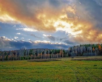
The property's lowest elevation (1,300' above sea level (Asl)) is along Route 16 where the headwaters of the Lamoille River meet Morrison and Page Brooks (all three streams flow through the land). At this intersection of streams is a wetland that is bisected by the access road leading into the land. It is this low point along the road access that truly adds to the land's sugarbush potential. From here, all terrain slopes uphill along the Page and Morrison Brook drainages to the height of land at 1,760' Asl. With the exception of a small area near the Lamoille River, all terrain is gently sloped, allowing for easy trail development and maintenance. Aspect is primarily west with some northern exposure at the land's southern end. Soil drainage is variable, with poorly-drained soils within the softwood stands where terrain is level. Soil drainage is also compromised in some hardwood areas where the terrain is nearly level. However, within the hardwood stands, soil productivity appears high, indicative of the sugar maple-dominated species composition and abundant maple and ash regeneration.
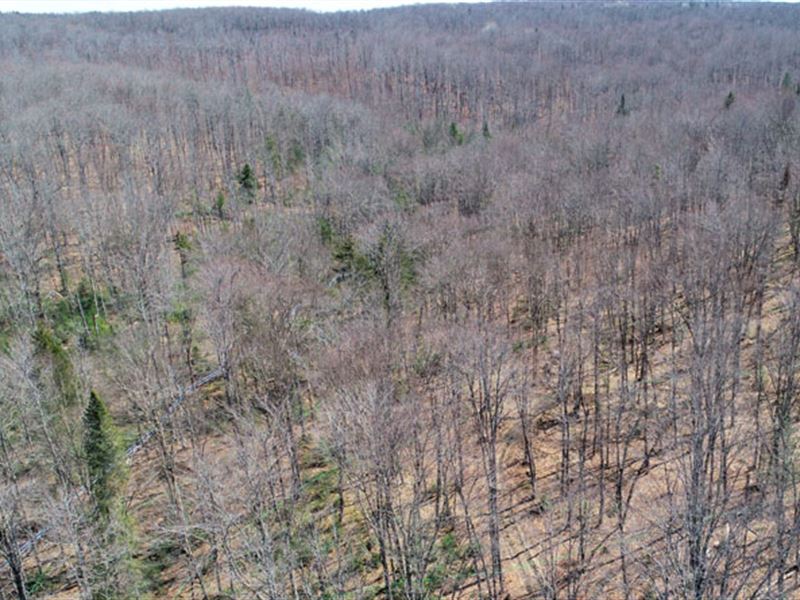
Timber
Timber data for this property are based on a monumented and comprehensive timber inventory completed in the winter of 2020 by F&W Forestry Services. 252 inventory plots were sampled (1 plot per 5 commercial acres), covering a 420' x 420' grid and using a 15-factor prism. The timber data reveal a total sawlog volume of 7,685 MBF International ¼” scale (6.1 Mbf/Commercial acre) with 22,467 pulpwood cords (17.9 cords/commercial acre). Combined total commercial per acre volume is 30.2 cords, well above the regional average. Stumpage values were assigned to the volumes in December of 2020, producing a property-wide Capital Timber Value (Ctv) of acre). A copy of the full timber inventory report is available upon request. A species composition dominated by hardwoods prevails, with hardwoods at 80% and softwoods at 20% of total volume. Species composition for all products combined offers a favorable mix and is led by sugar maple (42%), followed by yellow birch (16%), white ash (10%), cedar (11%), spruce/fir (9%) and red maple (8%), with other common hardwoods and softwoods comprising the balance. Forest density can generally be considered fully stocked, with the average Basal Area (Ba) at 101 sq ft on 163 stems/acre. Acceptable growing stock represents 67 stems/acre. Stem quality is generally average for the region, however with an unusually significant volume of high-quality, large-diameter stems. Maple and ash regeneration is abundant. About 18 years ago, conservative forest management was applied to stands 1 and 3C. Based on the UVA management plan, it appears stands 3U and 6 were treated ±32 years ago. A copy of the management plan is available on request. Average diameter for all products combined is 13.5”, while the average sawlog diameter is 14”. Average diameter for the four main species are: sugar maple 14”, yellow birch 15.0”, white ash 15.5” and spruce/fir 10.5”. Unlike many larger properties, the forest resource offers a wide range of diameters, which includes a high percentage of large-diameter, maturing stems. Of particular interest is the maturing white ash resource, which should be harvested due to the presence of Emerald Ash Borer in the state. This white ash resource alone will generate nearly in harvest income. While salvaging, other thinning is possible, providing additional, immediate income. In most areas, natural regeneration of good species is fully established, facilitating the establishment of a new crop in areas where the overstory is removed.