Riverfront/Recreational Land Water
370 Olson Ranch Rd : Smith, NV 89430
Lyon County, Nevada
Land Description
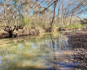
49+ Ac Recreational, Hunting, Fishing, Pasture, Hemp Land with Building site, 750+ Ft of West Walker River frontage and 101 Acre Feet of storage Water Rights from Topaz Reservoir For Sale at 370 Olson Ranch Rd. Smith, NV 89430.
Multiple species of wildlife call this property and Smith Valley home, including Mule Deer, Bear, Turkeys, Ducks, Geese, rabbits and multiple species of predators. Hunt and fish on your own land. Run some livestock on the irrigated pasture or just hold & enjoy as a 1st Class Rec property.
This property is ready for your dream home or cabin. Electricity is close and there are multiple luxury properties and ranches in the area. The parcel is also partially fenced for livestock. The Plymouth Irrigation ditch runs through the property bringing the 101 Acre Feet of invaluable water rights to this land, which are included in this sale. A concrete pad is already on the property and a Quonset style steel building is on-site and waiting to be built.
Location, Location, Location.
-3 Miles to Smith Valley Schools -
-35 Miles to Gardnerville, NV -
-83 Miles to the Reno-Tahoe International Airport -
-54 Miles to South Lake Tahoe -
-21 Miles to Topaz Lake and Lodge -
-21 Miles to Walker River State Recreation Area -
-68 Miles to Walker Lake State Recreation Area -
-105 Miles to Yosemite National Park -
Hunting This property lies within Nevada Dept. of Wildlife Hunt Unit 203.
Info below was taken from Ndow's Hunt Unit 203 Info Sheet Location This unit is located entirely within Lyon County. Elevation Elevation ranges from the valleys at 4,300' to Cleaver Peak's 7,300' summit.
TERRAIN & Vegetation Deer are found within the agricultural and riparian lands of Smith and Mason Valleys and along the Carson River. Deer feed in the croplands and retreat to the heavy brush and cottonwood forests for cover. Occasionally, deer can be taken on the adjacent mountains however, these mountains are dry and lack significant cover vegetation.
LAND Status Most of the land within Mason and Smith Valleys, where deer are present, is privately owned. The Mason Valley Wildlife Management Area Mvwma is owned and administered by Ndow. The Nevada Division of State Parks Ndsp owns and administers the Lahontan State Recreation Area Lsra involving a portion of the Carson River and Lahontan Reservoir. Hunter Access Some landowners will allow hunting on their land. Over 13,000 acres, the Mvwma is open to public hunting. Map
References The Carson City and Smith Valley 1 100,000 scale topographic maps delineate all topographic and road features within Unit 203. The Ndow has maps of the Mvwma at the manager's headquarters. The Ndsp has maps of the Lsra available as well. There are numerous 7.5-Minute scale topographic maps of the area as well. Topo maps sold at the Nevada Bureau of Mines & Geology, Mark, Fore & Strike, and U.S. Geological Services at the University of Nevada, at. The DeLorme Nevada Atlas and Gazetteer is available at most book or sporting goods stores, or by calling them direct at 1-.
Facilities And Services The cities of Yerington and Fernley are within Unit 203 and offer nearly all facilities and services. The communities of Silver Springs, Smith and Wellington also offer some services. Public campgrounds are available at Fort Churchill State Historic Park near Weeks. The Mvwma has a primitive campground.
RECOMMENDED Hunting Areas For Mule Deer Deer are distributed within the agricultural areas of Mason and Smith Valleys and along the cultivated and riparian habitat along the Carson River near Weeks. Without permission from a private landowner, the Mvwma is the first choice for a place to hunt. The Lsra also offers public land opportunity.
SPECIAL Comments Special regulations require that hunters only hunt with a shotgun or bow and arrow within the fenced and cultivated lands of Mason and Smith Valleys and on the Mvwma. This provision is in deference to human safety. Safety cannot be stressed enough however. Although not required by law, hunters in Unit 203 should consider wearing high visibility clothing to reduce the chance of accidental shootings within the dense foliage. The Mvwma also offers opportunity to hunt quail, rabbit and waterfowl.
Fishing
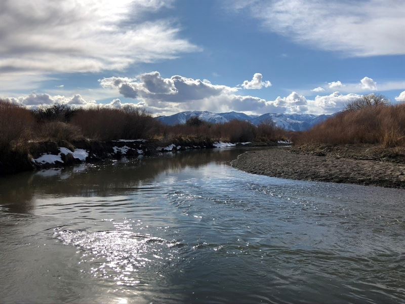
The West Walker runs for nearly 100 miles. Originating above Leavitt Meadows on the eastern edge of Yosemite National Park high in the Sierra Nevada, it follows Highway 108 and then flows along Highway 395 to Topaz Lake before eventually merging with the East Walker River in Nevada.
The freestone stream is made primarily of mountain snowmelt and because of its easy roadside access from the two highways that follow it, it's becoming a more and more popular place to fish every year.
Directions The West Walker flows along Highway 108, Sonora Pass Road, and follows Highway 395 all the way to Topaz Lake with lots of roadside access.
West Walker River Camping
There are several campgrounds and lodges along the West Walker River. The Bootleg and Chris Flat Campgrounds are both located along Highway 395 in the Walker River Canyon and are first come, first served. The smaller Leavitt Meadows and Sonora Bridge Campgrounds off Highway 108 offer a more rustic and remote experience. They are also first come, first served.
Directions The West Walker flows along Highway 108, Sonora Pass Road, and follows Highway 395 all the way to Topaz Lake with lots of roadside access.
Fishing the West Walker River
One the region's best freestone rivers, the West Walker is becoming a stronger fishery ever season. The West is heavily stocked with rainbow and brown trout and a lucky angler may even hook into a native Lahontan cutthroat or mountain whitefish.
Unlike many other fisheries in the region, flows are a very important factor to take into consideration when fishing the West Walker. The river can become un-fishable during spring run-off, so the best times to fish it are in the summer and fall. When flows are good, ideally below 200 cfs cubic feet per second, it can be a very productive fishery and one of the best wet-wading rivers in the region.
The West Walker is also home to two annual fishing derbies, the Size Doesn't Matter Derby and the How Big is Big Derby. Proceeds from both events go directly towards stocking the river. ~
Meet The Listing Realtor-Auctioneer