Eden-Craftsbury Forest
Bornemann Rd : Wolcott, VT 05652
Lamoille County, Vermont
Land Description
Introduction
Eden-Craftsbury Forest represents an exceptional timber investment opportunity with attractive species composition, mostly gentle terrain and diverse diameter distribution, including maturing stems, ensuring a regular, periodic flow of income from future forest management activity.
The ownership, Atlas Timberlands Partnership, is a collaboration between two conservation groups, The Nature Conservancy and the Vermont Land Trust. Together, they have held the property (along with other lands) as a model for managing a diverse array of stewardship goals, including the practice of sustainable silvicultural operations. Their goal in divesting is to raise funds to further their forestland conservation work on new projects.
Investment highlights include:
Pure timber investment, where existing conservation easement sets asking price at 72% of capital timber value;
Present ownership history of conducting silvicultural operations with focus on improving overall forest conditions;
Ideal species composition dominated by the maples and yellow birch;
Developed internal access;
Mostly gently sloping terrain, enhancing cost efficient forestry operations;
Recreational opportunity supported by the right to build a rustic camp.
Location
The property is located in north-central Vermont, within a rural, forested area and equi-distant from two state highways.
Craftsbury Village is 5 miles to the east, where Route 14 runs north and south to each end of the state. Eden Village is 5 miles to the west, where Route 100 runs from the Canadian border south to Massachusetts. Additionally, 20 miles to the northeast is the hamlet of Irasburg near Interstate 91. All three road corridors provide excellent access to diverse forest products manufacturing companies both regionally and into Canada.
Burlington, Vermont's largest city and home to an international airport, is a 1.25-Hour drive to the southwest. Montreal, Canada is a 2-hour drive to the northwest. Boston is roughly a 3.5 hour drive to the southeast.
Access
Most of the acres covering the 1,153-Acre Eden Unit is accessed by a right-of-way off Bornemann Road (as short spur that leads off the junction of Garfield and Craftsbury Roads). Once on the property, a ±5,700' truck road leads to nearly the center of the unit. From this point, a winter road heads ±4,500' west to the northwest section of the Eden Unit. The extreme eastern section of the Eden Unit and the southwestern section of the 948-Acre Craftsbury Unit have traditionally been accessed by a private road (by permission) extending beyond the end of Garfield Road.
The eastern end of the Craftsbury Unit is accessed by an undeveloped right-of-way from a private road off Collinsville Road that crosses the Wildbranch River and begins beyond a home. In the recent past, the north-central section of the Crafsbury Unit was accessed through an adjacent landowner's field, by permission, where a winter road has been built well into the land.
There is a 54-acre, landlocked parcel that comes with the land, located just north of the Eden Unit. No timber or contributory property value has been assigned to this parcel; however, it likely has value if sold to an adjacent landowner, something the seller has not explored.
Site Description
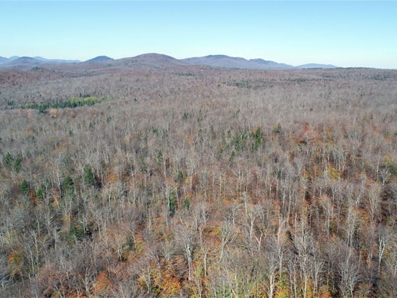
The property spans nearly 2.6 miles from north to south and, at its widest, stretches 3.4 miles across. This considerable footprint surprisingly covers mostly gently-sloping terrain with only one ridge just west of the town line. As such, there is minimal terrain relief, with the highest elevation of 1,700' ASL at two high points in the Eden Unit and the lowest elevation of 1,100' at the land's extreme eastern end, where the property nearly touches the Wild Branch River. This mostly gentle terrain allows for the easy movement of harvesting equipment and the low cost of road construction.
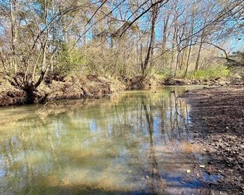
Several “top of the watershed” streams traverse the land, which create the various wetlands (covering ±176 acres) on the property. No timber data or property value is attributed to these wetland areas.
While high-density maple stands exist in many areas, the lack of consistent sloping terrain to access points limits opportunities on the property for large-scale sugarbush management; however, some areas have traits that offer potential.
Habitat for big game mammals is ideal; signs of moose, bear and white-tailed deer are common.
Timber
Timber data in this report are based on a monumented and comprehensive timber inventory, conducted in the fall of 2016. 388 points were sampled (1 plot per 5 commercial acres), covering a 460' X 460' grid and using a 15-factor prism. Sampling statistics are ±7.1% standard error for sawlog products and ±4.9% for all products combined at the 90% confidence interval, figures well within industry standards. Upon adding growth for 2017 through 2019, these data reveal a total sawlog volume of 7,578 MBF International ¼” scale (3.9 Mbf/Commercial acre) with 33,018 pulpwood cords (17.1 cords/commercial acre). Combined total commercial per acre volume is 25 cords, a figure in excess of the regional average. Stumpage values were assigned to the volumes in July of 2019, producing a property-wide Capital Timber Value (Ctv) of acre).
A species composition dominated by hardwoods prevails, with hardwoods at 88% and softwoods at 12% of total volume. Species composition for all products combined offers a favorable mix and is led by sugar maple (26% of total volume), followed by yellow birch (25%), red maple (19%), white ash (8%), beech (7%), spruce/fir (9%) and miscellaneous species making up the balance. The sawlog volume breakdown consists largely of species with historically strong demand, dominated by yellow birch, spruce/fir and the maples.
Sawlog value is largely dominated by sugar maple (31%) and yellow birch (25%), followed by white ash (16%), red maple (13%) and spruce/fir (11%).
Average diameter for all products combined by volume is 12.5”, while the average sawlog diameter is 13.5”. Average diameters for the four major species are sugar maple 14”, yellow birch 15”, red maple 15” and spruce/fir 11.5”.
Easement
The conservation easement on the property will be held by the Vermont Land Trust (Vlt), one of the most respected conservation organizations in the nation. A working forest “partnership” with VLT offers the new owner predictability and cooperation, given the long history and respected reputation this land trust has established.
A principal objective of the easement is to maintain and process healthy and abundant forest resources. The terms of the easement prevent subdivision and future development of any kind; however, forestry and sugarbush operations, and construction of associated support infrastructure, are permitted.
Easement highlights include:
Most sustainable and traditional forestry and sugarbush activities are permitted to support the long-term stewardship of the protected property;
The entire property is open to non-vehicular public recreation and hunting;
Silvicultural activities are limited to sustainable levels, with target diameters set for each species.
Surface Water Protection Zones (Swpzs), covering 230 acres, permit limited harvesting, with special consideration to maintaining water quality.
Copies of the easement and baseline documentation are available upon request.