Mountain Land Joins National Forest
County Road 651 : Rye, CO 81069
Huerfano County, Colorado
Land Description
73.43 Wooded Acres on Greenhorn Mountain with the entire Western Boundary bordering the San Isabel National Forest.
Call or Text anytime for questions or to purchase this property. Please reference the Property ID: Co_Huerfano_00056
The Western Boundary is 615 feet and borders over 1 Million acres of National Forest Land.
This National Forest land that borders the property consists of the Badito Cone, Greenhorn Mountain, and extends North to St Charles Peak, Deer Peak, Antelope Mountain, and Round Top Mountain. There are 449 known wildlife species in the combined Pike & San Isabel National Forests, including Elk, Bighorn Sheep, White-Tail and Mule Deer, Mountain Goat, Antelope, Black Bear, Wild Turkey, and many more.
The property is located in Colorado Game Management Unit 84.
The portion of San Isabel National Forest bordering the property is located in Ranger District 4/San Carlos Ranger District.
More specifically, the portion directly bordering the property is also referred to as Greenhorn Mountain Wilderness on interactive Forest Service Maps.
There are 40 foot access & utility easements already in place around the property. The property is just 0.3 miles from an established road to the North via the access easements. See photos for more details.
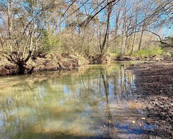
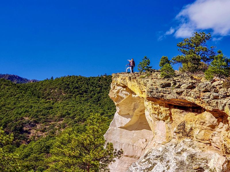
The unique topography of the property offers breathtaking views of the surrounding Forest and Mountain Peaks. There are large Rock Outcroppings on the property as well as areas featuring natural clearings, a lush ravine, and two seasonal creeks.
The peak elevation of the property is 8,080 feet with the lowest elevation being around 7,200 feet.
Electricity Lines & Poles are located 7/10th of a mile from the property to the Northeast.
Electric Company: San Isabel Electric, 122 W 6th St, Walsenburg, CO 81089
No Hoa, Covenants or Restrictions. There is no time limit to build.
There are Cabins, Site-Built Homes, Mobile Homes and Ranches on nearby parcels (see photos).
The property is just 8 miles to Interstate 25 which will take you directly to Walsenburg to the South.
The town of Walsenburg is just 23 miles away, where you will find groceries, fuel, supplies, restaurants, medical care, schools and professional services.
The Spanish Peaks Regional Health Center has a Level IV Trauma Center, specialty clinics and the 5 Star Rated Spanish Peaks Veterans Community Living Center.
Lathrop State Park is just South of the property and less than a 28 mile drive from this 73.43 Acre property. Lathrop State Park is Colorado's first State Park and consists of 1,594 Acres. Nestled in the shadow of the Spanish Peaks, Lathrop State Park has two lakes; Martin Lake and Horseshoe Lake. Activities at Lathrop State Park include Boating, Swimming, Jet Skiing, Water Skiing, Camping, Fishing, Golfing, Archery, Hunting for Waterfowl and Small Game.
Parcel Size: 73.43 Acres M/L
Property ID Number: Co_Huerfano_00056
Legal Description: CLL Ranch, Unit C, Lot 58B
Apn: 4030138
Property Taxes: / year
Title: Free & Clear
Conveyance: Warranty Deed
Approximate Distance to Nearby Cities & Points of Interest
19 minutes to Interstate 25
32 minutes to Walsenburg, CO : Population 3,200
41 minutes to the Lathrop State Park
46 minutes Pueblo, CO : Population 110,000
54 minutes to Lake Pueblo State Park
1 hour 2 minutes to Trinidad, CO : Population 10,000
1 hour 8 minutes to the Trinidad Lake State Park
1 hour 24 minutes to Colorado Springs, CO : Population 500,000
1 hour 36 minutes to Spanish Peaks State Wildlife Area
1 hour 50 minutes to Great Sand Dunes National Park & Preserve
2 hours 5 minutes Zapata Falls
2 hours 13 minutes to Blanca Peak
2 hour 32 minutes to Denver, CO : Population over 1 Million
GPS Coordinates
Northwest Corner: 37.997, -104.976542476144
Northeast Corner: 37.227, -104.958516706796
Southeast Corner: 37.508, -104.958541396044
Southwest Corner: 37.879, -104.976551037954
Center Point: 37.807056, -104.967814
Call or Text anytime for questions or to purchase this property. Please reference the Property ID: Co_Huerfano_00056