Flint River Cotton Boat Shoals
815 James Cross Ave : Albany, GA 31721
Dougherty County, Georgia
Land Description
Property Overview
+-122 Acre Cotton Boat Shoals Tract
On The Flint River
Dougherty County Ga
Property statistics following narrative. Terrastride interactive map has helpful files, pictures, and more. Visit the Matre Forestry website for more information.
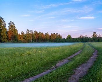
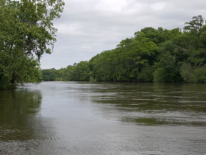
NARRATIVE: The Cotton Boat Shoals tract is +-122 acres with cabin on the beautiful Flint River in Dougherty County GA, with +-0.6 miles of river frontage on the west bank. Upriver from the property is Dougherty County and State of Georgia owned river green space, and just two parcels downriver is Ted Turners famous Nonami Plantation, then Blue Springs Plantation, and then the Melons Pineland Plantation. This very well could be your last chance to purchase coveted Flint River land, especially in Albanys quail plantation district, famous not just for fine quail hunting, but also huge bucks and gobblers. The property also offers awesome duck hunting, and hog hunting as they migrate up and down the river. Obviously, there great fishing all up and down the river, especially for the strong fighting shoal bass , huge stripers, and massive cats. Interested in arrowheads and other indian artifacts? If yes, you are interested in the Cotton Boat Shoals tract.
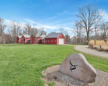
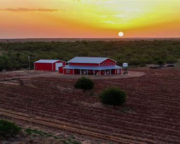
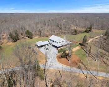
The cabin is a well cared for 875 heated/cooled square foot 1 bedroom 1 bath home with a nice kitchen and living area with fireplace, plus a 200 square foot screened porch, situated on a bluff with great views down to the river bottom. There is an extensive road network throughout the property, and deeded access to a private paved boat ramp. There is also a pole barn for boat and equipment storage. There are ideal homesites if you need more house and/or storage.
The property ranges from the gorgeous river bottom, up to the 100 year floodplain, and on up to the 500 year floodplain. There is an estimated 10 acres in the 500 year floodplain, ideal for building sites. Additionally, there is another +-12 acres in the 100 year flood plain. All throughout the property you stand a good chance of finding arrowheads and indian artifacts. Launch into the river from the paved private boat ramp and boat upriver 2.2 miles to gorgeous Radium Spring Creek, and another 1.4 miles is a public boat ramp on the east bank. 3.4 miles downriver from the property is Wilson Blue Spring, another 0.7 miles is Goat Island, and another 1.0 mile is a public boat ramp and camp grounds on the east bank. At the properties southeast corner, there is a small island.
Whats the story on the name Cotton Boat Shoals (also known as Cotton Boat Farms)? At the property there are some shoals known as Cotton Boat Shoals, where in the 1800S a cotton boat/barge shipping cotton to Apalachicola wrecked. The remains of the boat are still there.
Some divisions considered (already surveyed in multiple parcels). Note: +-33 acres suffered significant tornado timber damage in January of 2017. Most of the tornado damage occurred in the oak hammocks (higher sites in the river bottom), in several patches ranging from +-1 acre to +-17 acres in size. These areas add to wildlife habitat diversity (a good thing), and there are still scattered and patches of mature oak and other species still standing in the tornado damage area. The +-33 acres of tornado damage is ideal for natural hardwood regeneration, or could be cleaned up and planted in pines and/or left open for river bottom food plots. Even though the tornado damage is in the river bottom, most of the soils appear to be suitable for loblolly pine, which naturally grow fast big and tall in the Flint River bottoms, especially on hammocks that drain well after flooding. There is a risk that an untimely flood could hurt pine seedlings, but once established, a pine stand can handle the seasonal flooding.
DISCLAIMER All information is believed to be reliable and from reliable sources, but the information is not guaranteed.
NOTICES: Shown by appointment only. Do not enter without permission. The property is for sale, not for lease. See attached files/documents for more info.
LISTING Broker:. of Albany GA. Established in 1999, Matre Forestry assists clients with land sales, acquisitions, and management. Contact us today. Licensed in GA & Al.
Listing Agent: , Broker, Accredited Land Consultant, Association of Consulting Foresters.
COUNTRY: US State: GA County: Dougherty
Acres +-: 122
Primary Use: Hunting, Timber, River Property, Home sites, Ideal for Conservation Easement
PROPOSED/POTENTIAL Use: Hunting, Timber, River Property, Home sites, Ideal for Conservation Easement
LEGAL Description: Multiple adjoining parcels
ZONING: Ag and Residential
FLOOD Zone: +-10 acres is in the +-500 year floodplain, +-12 acres in the +-100 year floodplain, and +-100 acres is in the floodway.
TEMPORARY Conservation Use Assessment: Under the temporary (10 Year) Conservation Use Assessment (Cua), expiring 2022
Permanent Conservation Easement: No
Estimated Annual Property Tax: Annual Farm Rent: N/A
Improvements: House, pole barn, deed access to private paved boat ramp, extensive road network.
ESTIMATED Timber Value: Mature pine and hardwood, planted pines in pulpwood stage never thinned, and 2017 natural hardwood regen (tornado damage area).
HUNTING: Great Flint River hunting tract for deer, turkey, ducks, hogs
Crop Basis: N/A
Soils: Dominant river bottom soil is +-90 acres Dunbar-Izagora-Bladen complex (occasionally flooded, somewhat poorly drained); and dominant upland soil is +-10 acres Orangeburg loamy sand, 2 to 5 percent slopes (no flooding, well drained). (Source: Usda Soil Map)
WATER Resources: +-0.6 Miles Flint River frontage, oak/cypress sloughs and ancient river bed, house well water
TOPOGRAPHY: Flat to gentle roll. There is a major natural levie traversing the property, and the river bottom varies in elevation from sloughs, flat bottoms, to higher hammocks, and natural levees and drains.
LOCATION/ACCESS: Paved road frontage on James Cross Ave (+-20 at end of road) and Victory Drive (490)
Other: Indian artifacts are common. Will consider dividing. Surveyed into multiple parcels.